- Tikei
-
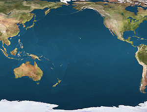
 TikeiLocation of Tikei Island in the Pacific Ocean
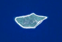 NASA picture of Tikei Island.
Tikei, also known as Manu, Tikai and Tiku is an island in the Tuamotu group in French Polynesia. Tikei is not a typical Tuamotu atoll, but a separate island. Maximum length: 2.8 Km, maximum width 1.2 Km. (Latitude: 14° 58' 0 S, Longitude: 144° 31' 60 W)
Geographically Tikei is part of the King George Islands (Iles du Roi Georges) subgroup, which includes Ahe, Manihi, Takapoto, Takaroa and Tikei
Tikei is presently uninhabited. Formerly there was human habitation and the main village was called Tereporepo. The closest land is Takapoto Atoll, located 73 Km to the Northwest. Tikei Island has been poorly researched.
Contents
History
The first recorded European to arrive to Tikei was Dutch mariner Jacob Roggeveen on May 18, 1722. He named this island "Carlshoff".
1816 Russian mariner Otto von Kotzebue came to Tikei in 1816. He named it "Romanzov", after the main sponsor of his expedition.
Administration
Tikei belongs to the commune of Takaroa, which consists of the island of Takaroa, as well as the island of Tikei and the atoll of Takapoto.
References
External links

Tuamotus

GambiersIslands/Atolls: Ahe • Ahunui • Akiaki • Amanu • Anaa* • Anuanuraro • Anuanurunga • Apataki • Aratika • Arutua* • Faaite • Fakahina • Fakarava* • Fangatau* • Fangataufa • Hao* • Haraiki • Hereheretue • Hikueru* • Hiti • Katiu • Kauehi • Kaukura • Makatea • Makemo* • Manihi* • Manuhangi • Maria Est • Marokau • Marutea (North) • Marutea (South) • Mataiva • Matureivavao • Morane • Moruroa • Motutunga • Napuka* • Nengonengo • Niau • Nihiru • Nukutavake* • Nukutepipi • Paraoa • Pinaki • Puka Puka* • Pukaruha • Rangiroa* • Raraka • Raroia • Ravahere • Reao* • Reitoru • Rekareka • Taenga • Tahanea • Taiaro • Takapoto • Takaroa* • Takume • Tatakoto* • Tauere • Tekokota • Tematangi • Temoe • Tenararo • Tenarunga • Tepoto (North) • Tepoto (South) • Tikehau • Tikei • Toau • Tuanake • Tureia* • Vahanga • Vahitahi • Vairaatea • Vanavana * commune administration centerIsland groups: Acteon • Disappointment • Duke of Gloucester • King George • Two Groups • Palliser • RaeffksyCategories:
- Islands of the Tuamotus
- Uninhabited islands of French Polynesia


Wikimedia Foundation. 2010.