- Coburn, Pennsylvania
-

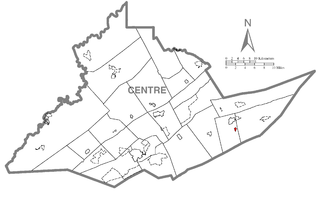
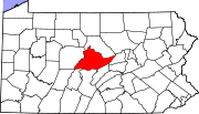
Coburn is a census-designated place (CDP) in Centre County, Pennsylvania, United States. It is part of the State College, Pennsylvania Metropolitan Statistical Area. The population was 145 at the 2000 census.
Geography
Coburn is located at 40°51′47″N 77°27′45″W / 40.862966°N 77.462379°WCoordinates: 40°51′47″N 77°27′45″W / 40.862966°N 77.462379°W (40.862966, -77.462379).[1]
According to the United States Census Bureau, the CDP has a total area of 0.2 square miles (0.52 km2), all of it land.
Demographics
As of the census[2] of 2000, there were 145 people, 57 households, and 40 families residing in the CDP. The population density was 665.8 people per square mile (254.5/km2). There were 62 housing units at an average density of 284.7/sq mi (108.8/km2). The racial makeup of the CDP was 97.93% White, 0.69% Asian, and 1.38% from two or more races. Hispanic or Latino of any race were 0.69% of the population.
There were 57 households out of which 28.1% had children under the age of 18 living with them, 57.9% were married couples living together, 8.8% had a female householder with no husband present, and 28.1% were non-families. 19.3% of all households were made up of individuals and 8.8% had someone living alone who was 65 years of age or older. The average household size was 2.54 and the average family size was 2.90.
In the CDP the population was spread out with 22.1% under the age of 18, 7.6% from 18 to 24, 24.1% from 25 to 44, 31.7% from 45 to 64, and 14.5% who were 65 years of age or older. The median age was 42 years. For every 100 females there were 110.1 males. For every 100 females age 18 and over, there were 101.8 males.
The median income for a household in the CDP was $47,083, and the median income for a family was $37,500. Males had a median income of $29,167 versus $33,125 for females. The per capita income for the CDP was $16,510. There were 7.9% of families and 13.6% of the population living below the poverty line, including 30.6% of under eighteens and none of those over 64.
References
- ^ "US Gazetteer files: 2010, 2000, and 1990". United States Census Bureau. 2011-02-12. http://www.census.gov/geo/www/gazetteer/gazette.html. Retrieved 2011-04-23.
- ^ "American FactFinder". United States Census Bureau. http://factfinder.census.gov. Retrieved 2008-01-31.
Municipalities and communities of Centre County, Pennsylvania Boroughs Bellefonte | Centre Hall | Howard | Milesburg | Millheim | Philipsburg | Port Matilda | Snow Shoe | State College | Unionville
Townships CDPs Aaronsburg | Blanchard | Boalsburg | Clarence | Coburn | Eagleville | Houserville | Julian | Lemont | Madisonburg | Monument | North Philipsburg | Park Forest Village | Pine Glen | Pine Grove Mills | Pleasant Gap | Ramblewood | Rebersburg | Sandy Ridge | Spring Mills | Stormstown | Woodward | Zion
Unincorporated
communitiesColyer | Graysdale | Gum Stump | Ingleby | Peru | South Philipsburg | Struble | Tusseyville | University Park | Waddle
Categories:- Census-designated places in Centre County, Pennsylvania


Wikimedia Foundation. 2010.