- Silva Carbonaria
-
 The Silva Carbonaria during the 5th century, in green
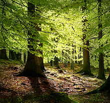 Compared to modern old-growth beech forests (shown here: Grib Skov, Nordsjælland, Denmark), Silva Carbonaria was remarkably dense
Silva Carbonaria, the "charcoal forest",[1] was the dense old-growth forest of beech and oak that formed a natural boundary during the Late Iron Age through Roman times into the Early Middle Ages across what is now Belgium. The forest naturally thinned out in the open sandy stretches to the north and formed a barrier—trackless to the outsider—on the heavier soils to the south. Yet further to the south, the higher elevation and deep river valleys were covered by the even less penetrable ancient Arduenna Silva, the deeply folded Ardennes, which are still forested to this day. The Silva Carbonaria was a vast forest that stretched from the rivers Senne and the Dijle in the north to the Sambre in the south.[2] To the east Silva Carbonaria extended to the Rhine, where near Cologne in 388 CE the magistri militum praesentalis Nannienus and Quintinus[3] counterattacked a Frankish incursion across the Rhine in the Silva Carbonaria.[4] Its northern outliers reached the then marshy site of modern Brussels.[5]
Contents
Roman road
A great Roman road forming a "strategic axis"[6] linked the Rhine crossing at Cologne with Maastricht, where it crossed the Maas at the head of navigation. Skirting the northern edges of the Silva Carbonaria, it passed through Tongeren, Kortrijk and Cambrai to reach the sea at Boulogne. The highway was the main east–west route in a landscape where the river valleys, tributaries of the Meuse and the Scheldt, tended southwest to northeast. It remained viable through the Early Middle Ages as the chaussée Brunehaut, the "Road of Brunehaut". As a public work its scale had become unimaginable in the Middle Ages: the chronicler Jean d'Outremeuse solemnly related in 1398 that Brunehaut, wife of Sigebert I, had built this wide paved road in 526, and that it was completed in a single night with the devil's aid.[7]
The Silva Carbonaria as a border
When the Franks settled on the left bank of the Rhine in the fourth century, the Salian Franks rapidly occupied the flat open country with its coastal marshes, and the mixed tribal groups that Romans called Belgae withdrew to the wooded south;[8] there the Romanized Celts—the "Wala" or "strangers" to the Germanic Franks—continued speaking a Late Latin: their label as Wala survives in Walloon. In the past the Romance-Germanic linguistic division that marks Belgium to this day has been perhaps too facilely linked[9] to these geographic parameters.[10]
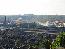 In the 19th century, the iron ore in the formerly wooded valleys fuelled the sillon industriel of Wallonia
The Silva Carbonaria is mentioned in the Salic Law of the Franks,[11] where it marked "the boundary of the territories occupied by the Frankish people".[12] For a time in the sixth century, the Silva Carbonaria formed a barrier between the West Frankish kingdom of Clovis and the East Frankish kingdom of Sigebert the Lame,[13] centred on Cologne, until he was defeated some time after 507, and Clovis joined the two kingdoms, which however retained their separate identities throughout the rule of the Merovingians.
Extensive tracts of the untamed woodlands belonged to monasteries. The Benedictine Abbey of Lobbes lay in the Silva Carbonaria and that of Saint Foillan, in the Sonian Forest (Forêt de Soignes/Zoniënwoud) not far from Nivelles.[14]
Economic importance
The charcoal—which gave the forest its name and into which the once seeming inexhaustible woods were slowly converted—was required to fuel the scattered smelting furnaces that forged the plentiful iron found in outcroppings laid bare by riverside erosion. Even before the Romans arrived, iron weapons forged in the Silva Carbonaria were traded by the Belgae to their cousins in the southeast of Britain. In the High Middle Ages further woodlands were cleared. Today the most significant remnant[15] of the Silva Carbonaria is the Sonian Forest,[16] preserved because it had been set aside as a noble hunt. At the start of the nineteenth century the area of this remnant of the primeval forest still covered about 100 square kilometres, but due to timber cutting its area has diminished to its current protected area of 44.21 km².
Notes
- ^ Or Carbonarius saltus, "the charcoal ravine or wildwood" — in the sense of "unfit for the plough" (Hoffmann 1698, s.v. "Carbonarius saltus"); the lexicographer Hoffmann found Carbonaria silva mentioned by Gregory of Tours, the twelfth-century chronicler Sigebert of Gembloux, and Johannes Trithemius.
- ^ F. L. Ganshof, "Manorial Organization in the Low Countries in the Seventh, Eighth and Ninth Centuries" Transactions of the Royal Historical Society, 4th Series 31 (1949:29-59) p. 30.
- ^ A. H. M. Jones, John Robert Martindale, J. Morris, eds. The Prosopography of the Later Roman Empire, 1971 s.v. Quintinus"
- ^ According to Sulpicius Alexander, quoted in Gregory of Tours, History of the Franks ii.9: multos Francorum, qui Rhenum transierant, a Romanis apud Carbonariam ferrô peremptos tradit, quoted by Hoffmann 1698.
- ^ André De Vries, Brussels: A Cultural and Literary History, 2003:18.
- ^ Van Durme 2002:11.
- ^ The confused legendary origins of the chausée Brunehaut were unraveled and examined by J. Lestoquoy, "L'étrange histoire de la Chaussée Brunehaut", in Arras au temps jadis1946; see "Presentation of Brunehaut and its villages".
- ^ Émile Cammaerts, A History of Belgium from the Roman Invasion to the Present Day, 1921: ch. 1 "the Coal Wood".
- ^ Cammaerts 1921:34, in general following conclusions based on toponymy by the historian Godefroid Kurth.
- ^ The historiography of this idea is traced by Luc van Durme in "Genesis and evolution of the Romance-Germanic language border in Europe", in Jeanine Treffers-Daller and Roland Willemyns, eds. Language Contact at the Romance-Germanic Language Border, 2002:39ff.
- ^ Title 47 of Lex Salica specifies that the interested parties in a contested ownership meet within forty days if they live within the bounds of the Silva Carbonaria and the Loire; otherwise eighty days must be allowed. (T.M. Charles-Edwards, in Iorwerth Eiddon and Stephen Edwards, eds. The Cambridge Ancient History, vol. XV [Cambridge University Press] 2005:273.
- ^ As Gregory of Tours noted, Rhenum transierunt, pluribus suorum in Romano relictis solo, ad repetendam depopulationem paratis, cum quibus congressua Romanis adcomodus fuit, multis Francorum apud Carbonariam ferro perimptis. (Historia Francorum ii.9.).
- ^ "At that stage, the silva Carbonaria separated Clovis's Salian kingdom from Sigebert's eastern domain." (The Cambridge Ancient History, eo.loc.); "The Silva Carbonaria formed for a time a natural barrier between Salians and Ripuarians, though it may not have proved very effective," (John Michael Wallace-Hadrill, The Barbarian West, 400-1000 1996:70); in the chronicle of the Monastery of Saint Arnulf, under the year 690: adunatô exercitu Peppinus ad Carbonariam silvam pervenit: qui terminus utraque Regna dividit.
- ^ Hoffmann 1698, Laubiense Monasterium in Silva Carbonaria esse situm, auctore Fulcuinô; esse et Coenobium S. Foillani in silva Soniaca parte Carbonariae non longe a Niviala:
- ^ There are seven other forests in Belgium that are also remains of the Silva Carbonaria
- ^ De Vries 2003:13; Hofmann, in the late seventeenth century, noted this remnant in writings of Gotefridus Wendelinus and also remarked on remnants in the Forêt de Mormaux or Mormal, the Bois de Cirau, and the woodland called Die Leu that stretched from Leuven to the gates of Diest, the forest-covered Hageland or Hagelanden.
References
- Hofmann, Johann Jacob. Lexicon Universale, Historiam Sacram Et Profanam Omnis aevi... (Leiden) 1698. on-line facsimile text on-line transcript.
- Duvivier, Charles, "La forêt charbonnière: Silva Carbonaria", in Revue d'histoire et d'archéologie 3 (1862:1-26).
Categories:- Forests of Belgium
- Geography of Belgium
- Old growth forests


Wikimedia Foundation. 2010.