- North Goa
-
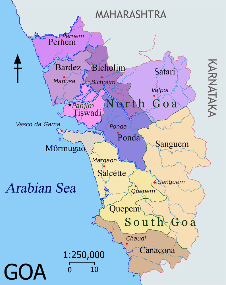
 North Goa and its talukas shown in shades of purple
North Goa is one of the two districts that make up the state of Goa, India. The district has an area of 1736 km², and is bounded by Sindhudurg and Kolhapur districts of Maharashtra state to the north and east respectively, by South Goa District to the south, and by the Arabian Sea to the west.
Contents
Historical background
Much of the today's North Goa territories (Pernem, Bicholim, and Sattari) were under the Kingdom of Sawantwadi. While Ponda was sometimes with Sunda Kingdom or Marathas or Kingdom of Sawantwadi. Hence these territories were seen as safe haven for the Hindus who were under the continuous fear Portuguese Inquisition. These territories were conquered by Portuguese as part of New Conquest in late 18th centuries. These territories then remain with Portuguese till 1961 till it was annexed by India. Goa and two other former Portuguese enclaves became the union territory of Goa, Daman and Diu, and Goa was organized into a single district in 1965. On 30 May 1987, Goa attained statehood (while Daman and Diu remained a union territory), and Goa was reorganized into two districts, North Goa and South Goa.
Geography
Its geographical position is marked by 15o 48’ 00” N to 14o 53’ 54” N latitudes and 73o E to 75o E longitudes
Climate
Climate data for Panaji Month Jan Feb Mar Apr May Jun Jul Aug Sep Oct Nov Dec Year Average high °C (°F) 31.6
(88.9)31.5
(88.7)32.0
(89.6)33.0
(91.4)33.0
(91.4)30.3
(86.5)28.9
(84.0)28.8
(83.8)29.5
(85.1)31.6
(88.9)32.8
(91.0)32.4
(90.3)31.28
(88.31)Average low °C (°F) 19.6
(67.3)20.5
(68.9)23.2
(73.8)25.6
(78.1)26.3
(79.3)24.7
(76.5)24.1
(75.4)24.0
(75.2)23.8
(74.8)23.8
(74.8)22.3
(72.1)20.6
(69.1)23.21
(73.77)Precipitation mm (inches) 0.2
(0.008)0.1
(0.004)1.2
(0.047)11.8
(0.465)112.7
(4.437)868.2
(34.181)994.8
(39.165)518.7
(20.421)251.9
(9.917)124.8
(4.913)30.9
(1.217)16.7
(0.657)2,932
(115.43)Source: wunderground.com[1] Administration
The administrative headquarters of the district is Panaji, which is also the capital of the state of Goa. The district forms a part of greater region called Konkan.
The district is divided into four subdivisions - Mapusa, Bicholim, Panaji, and Ponda; and six taluks, Pernem, Bardez (Mapusa), Bicholim, Sattari (Valpoy), Tiswadi (Panaji) and Ponda.
Demographics
According to the 2011 census North Goa has a population of 817,761 ,[2] roughly equal to the nation of Comoros[3] or the US state of South Dakota.[4] This gives it a ranking of 480th in India (out of a total of 640).[2] The district has a population density of 471 inhabitants per square kilometre (1,220 /sq mi) .[2] Its population growth rate over the decade 2001-2011 was 7.8 %.[2] North Goa has a sex ratio of 959 females for every 1000 males,[2] and a literacy rate of 88.85 %.[2]
Konkani is mother tongue of majority of people living in North Goa district. Marathi is spoken by a substantial number of people as mother tongue. English and Hindi are understood by a majority of the population. Portuguese is also spoken and understood by a small number of people.References
- ^ "Historical Weather for Panaji, India". Weather Underground. http://www.wunderground.com/NORMS/DisplayIntlNORMS.asp?CityCode=42182&Units=both. Retrieved November 27, 2008.
- ^ a b c d e f "District Census 2011". Census2011.co.in. 2011. http://www.census2011.co.in/district.php. Retrieved 2011-09-30.
- ^ US Directorate of Intelligence. "Country Comparison:Population". https://www.cia.gov/library/publications/the-world-factbook/rankorder/2119rank.html. Retrieved 2011-10-01. "Comoros 794,683 July 2011 est."
- ^ "2010 Resident Population Data". U. S. Census Bureau. http://2010.census.gov/2010census/data/apportionment-pop-text.php. Retrieved 2011-09-30. "South Dakota 814,180"
External links

Sindhudurg district, Maharashtra Arabian Sea 
Belgaum district, Karnataka  North Goa district

South Goa Uttara Kannada district, Karnataka Goa History Government Chief Ministers · Legislative Assembly · Raj Bhavan · State seal · Political parties · Goa Police · Goa civil codeGeography Districts North Goa · South GoaTalukas Cities Heritage sites Wildlife sanctuaries Education Science Goans in science · National Institute of Oceanography · National Centre for Antarctic and Ocean ResearchCulture Comunidades · Cuisine · Goans · Konkani cinema · Konkani language · Literature · Media · Music · Shigmo · Goans in sports · TiatrSports TeamsGoa football team · Goa cricket team · Churchill Brothers SC · Dempo SC · Salgaocar SC · Sesa Football Academy · Sporting Clube de Goa · Vasco SCStadiaCompetitionsGoa Professional LeagueTransport Portal • Category • Wikiproject Categories:- Districts of Goa
- Goa geography stubs
Wikimedia Foundation. 2010.