- Old Loggers Path
-
Old Loggers Path 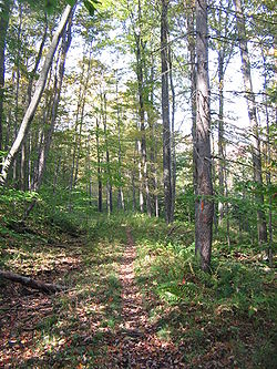
The Old Loggers Path north of Masten in McNett Township, Lycoming County Length 27.1 mi; 43.6 km Location Lycoming County, Pennsylvania, USA Trailheads 2.7 miles southwest of Ellenton, Pennsylvania on Legislative Route 41110 just past the stop sign in Masten, a ghost lumber town. Use Hiking Elevation Change 3500 feet (1070 m) Trail difficulty Easy to Moderate Season Spring to Fall Sights Vistas Hazards Severe Weather, Poison ivy, Bears The Old Loggers Path (OLP) is a 27.1 mile (43.6 km) loop hiking trail in Lycoming County in north central Pennsylvania in the United States. Marked with international orange blazes, the Old Loggers Path is located entirely within the Loyalsock State Forest. Most hikers take two and a half to three days and two nights to complete the Old Loggers Path, making it popular for weekend hikes. Highlights of the trail include waterfalls, several scenic streams and creeks (most of which do not have bridges), and panoramic vistas.
The land the Old Loggers Path is on was initially owned and clear-cut by the Union Tanning Company, followed by the Central Pennsylvania Lumber Company. The trail chiefly follows the grades of abandoned logging roads and railroads, and its trailhead is the lumber ghost town of Masten. Parts of the trail were made by the Civilian Conservation Corps, which operated a camp in the area from 1933 to 1941.[1]
Contents
History
Masten was founded as a lumber mill town in 1905 by Charles W. Sones. Sones owned the mill and town and worked under a contract with the Union Tanning Company, which needed hemlock bark for tanning leather and also sold hardwoods from the area. The village was served by two railroad lines: the Susquehanna and New York Railroad and the Susquehanna and Eagles Mere Railroad. The railroads passed through many cuts and fills, and the grades built at the height of the lumber era in Pennsylvania today carry the Old Loggers Path.[2]
In April 1917 the contract with Sones expired and the mill, town, and railroads were purchased by the Central Pennsylvania Lumber Company. The mill was in operation from 1905 to September 18, 1930, when the last log was cut. After the mill closed, many of the houses were torn down and their lumber sold and the Susquehanna and Eagles Mere Railroad was abandoned.[2] On May 6, 1933, Civilian Conservation Corps "State Forest Camp" S-80-Pa was established at the site of Masten, and some of the remaining houses were demolished to make room for the camp. The CCC built some 30 miles (48 km) of roads and 40 miles (64 km) of trails. The camp closed in 1940.[3][4] Some families had stayed after the mill closed and during the CCC era, but in 1941 the last family left Masten.[2] The Old Loggers Trail was established after the Second World War. Today, few buildings remain, which are now hunting camps, but there are many foundations throughout the area, and a smokestack.
Trail
A free map of the Old Loggers Path is available from the Loyalsock State Forest Office and online.[5] Most hikers completing the whole trail start at the trailhead in Masten and head north (as this makes some of the steeper grades descents rather than climbs). The Old Loggers Path is blazed in international orange, with double blazes and/or arrows to mark a change in direction.
Leaving Masten, the trail crosses Hoghouse Run, one of many streams along the path. It follows parts of several old roads and grades, and modern hiking and cross-country skiing trails, including the Sharp Shinned Ski Trail. At just over 6 miles (10 km) the trail reaches Rock Run, which has worn a series of pools into the rock near a camping area. Another camping area used for the first night stop is at Doe Run, 10 miles (16 km) along the trail. There are picturesque views of the McIntyre Wild Area of the Loyalsock State Forest across Rock Run. The Old Loggers Path next reaches Buck Run, then climbs Sullivan Mountain and reaches Pleasant Stream, a tributary of Lycoming Creek. The road along Pleasant Stream is the old Susquehanna and New York Railroad bed, and the trail crosses the stream at 16.6 miles (26.7 km) - there is no bridge. Tom Thwaites writes of Sharp Top Vista, at 18.9 miles (30.4 km): "I find it hard to understand why this view isn't famous. In front of you the world drops away to reveal a broad wooded valley surrounded by mountains."[6] A good camping site for the second day is at the East Branch of Wallis Run, a tributary of Loyalsock Creek, at 20 miles (32 km). The last section of the trail has Sprout Point Vista, which has a similar view. At 23.3 miles (37.5 km) the Hillsgrove Road is reached, which is the old Susquehanna and Eagles Mere Railroad bed. The trail follows Burnetts Ridge and Bear Run back to the Pleasant Stream valley, eventually returning to the trailhead at Masten.
External links
References
- ^ "Old Loggers Path". Pennsylvania Department of Conservation and Natural Resources. http://www.dcnr.state.pa.us/forestry/hiking/logger.aspx. Retrieved 2007-09-27.
- ^ a b c Taber III, Thomas T.. "Chapter 3.2: Sonesville, Masten, and C.W. Sones". Gost Lumber Towns of Central Pennsylvania. Muncy, Pennsylvania: Self-published (No ISBN).
- ^ "Pennsylvania CCC Archive: Camp Information for S-80-Pa". Pennsylvania Department of Conservation and Natural Resources. http://www.dcnr.state.pa.us/stateparks/ccc/camp.aspx?ID=106. Retrieved 2007-09-29.
- ^ "History Company 301, S-80-Pa, Masten, Pa." (PDF). Pennsylvania Department of Conservation and Natural Resources. http://www.dcnr.state.pa.us/stateparks/ccc/docs/14.pdf. Retrieved 2007-09-29.
- ^ "Old Loggers Path Map". Pennsylvania Department of Conservation and Natural Resources. http://www.dcnr.state.pa.us/forestry/hiking/loggermap.aspx. Retrieved 2007-09-28.
- ^ Thwaites, Tom (1992). Fifty Hikes in Central Pennsylvania (Fourth updated printing ed.). Woodstock, Vermont: Backcountry Publications. pp. 176–180. ISBN 0-942440-24-2.
Coordinates: 41°31′18″N 76°53′47″W / 41.52167°N 76.89639°W
Hiking Trails in Pennsylvania 202 • Appalachian • Baker • Black Forest • Brandywine • Bucktail Path • Chester Valley • Chuck Keiper • Conestoga • Cresheim • Cross County • Darlington • Donut Hole • Evansburg • Forbes Road • GAP • GET • Glacier Ridge • Golden Eagle • Horse Shoe • John P. Saylor • Laurel Highlands • Liberty Bell • Lost Turkey • Lower • Loyalsock • Mason-Dixon • Mid State • Mill Creek • Montour • North Country • Old Loggers Path • Panhandle • Pennypack • Perkiomen • Pinchot • Potomac Heritage • Power Line • Quebec Run • Quehanna • Rachel Carson • Rock Run • Schuylkill East • Schuylkill River • Standing Stone • Struble • Susquehannock • Tanbark • Terrace Mountain • Thunder Swamp • Tuscarora • Valley Forge • Warrior • West County • West Rim • Wissahickon • Youghiogheny River
 Categories:
- Hiking trails in Pennsylvania
- Civilian Conservation Corps in Pennsylvania
- Protected areas of Lycoming County, Pennsylvania


Wikimedia Foundation. 2010.