- Newingreen
-
Coordinates: 51°05′05″N 1°02′05″E / 51.0846°N 1.0346°E
Newingreen 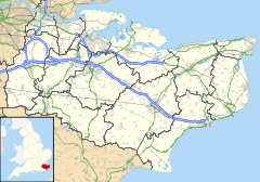
 Newingreen
Newingreen shown within KentDistrict Shepway Shire county Kent Region South East Country England Sovereign state United Kingdom Police Kent Fire Kent Ambulance South East Coast EU Parliament South East England UK Parliament Folkestone and Hythe List of places: UK • England • Kent Newingreen is a village near Folkestone in Kent, England. It is situated on the A20, near Junction 11 of the M20. Historically it was at the junction of Stone Street and the road to Folkestone.
The village contains the global headquarters of Holiday Extras.
External links
 Media related to Newingreen at Wikimedia Commons
Towns and villages in the Shepway district of Kent, England 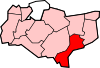 Acrise · Arpinge · Beachborough · Bladbean · Bodsham · Breach · Brenzett · Brookland · Burmarsh · Cheriton · Danton Pinch · Densole · Dymchurch · Dungeness · Elham · Elmsted · Etchinghill · Folkestone · Frogholt · Greatstone-on-Sea · Hawkinge · Hythe · Ivychurch · Lade · Littlestone-on-Sea · Lydd · Lydd-on-Sea · Lyminge · Lympne · Monks Horton · Newchurch · Newingreen · Newington · New Romney · Old Romney · Paddlesworth · Pedlinge · Peene · Postling · Rhodes Minnis · Saltwood · Sandgate · Sandling · Sellindge · Selsted · Snargate · Stanford · Stelling Minnis · St Mary in the Marsh · St Mary's Bay · Westenhanger · West Hythe · Wingmore
List of places in Kent Categories:- Villages in Kent
- Kent geography stubs


Wikimedia Foundation. 2010.