- Ou Chrov District
-
Ou Chrov
ស្រុកអូរជ្រៅ— District (srok) — The Thai Cambodian border crossing at Poipet Map showing the location of the district within Banteay Meanchey Province.
 Location in Cambodia
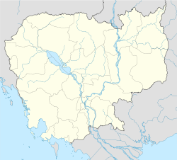
 Ou Chrov
Coordinates: 13°39′N 102°34′E / 13.65°N 102.567°ECoordinates: 13°39′N 102°34′E / 13.65°N 102.567°E Country  Cambodia
Province Banteay Meanchey Communes 8 Villages 75 Population (1998)[1] – Total 100,590 Time zone +7 Geocode 0105 Ou Chrov District (Khmer: ស្រុកអូរជ្រៅ) is a district (srok) in the west of Banteay Meanchey Province in north-western Cambodia. The border town of Poipet is located within the district. Poipet is the district capital and is located around 48.5 kilometres due west of the provincial capital of Sisophon by road. Ou Chrov District is one of the western-most districts of Banteay Meanchey. The district borders on Thailand and Poipet contains a popular international border crossing which is home to numerous casinos.[2]
The district is easily accessed by road from Sisophon (48 km) and Bangkok (230 km). Ou Chrov District is an average land size compared to other Banteay Meanchey districts however it has a large district population due to the border crossing and related industry. National Highway 5 which begins in Phnom Penh and ends at Poipet bisects the district running from east to west. The main road access to isolated Malai District begins from the national highway not far from Poipet town. although there is only one official border crossing in the district, numerous smaller roads in the district also run to various locations on the border.[3]
Contents
Administration
The Ou Chrov District governor reports to His Excellency Oung Ouen, the Governor of Banteay Meanchey. The following table shows the villages of Ou Chrov district by commune.
Khum (Communes) Phum (Villages) Changha Boeng Seila, Ta Chrueng, Ta Phaok, Paoy Voat, Chhuk, Chrey Koub Yeang thmei, Mak Heun, Veang Muong, Koub Kaeut, Khai Dan, Naka Chhay, Koub Lech, Koub Cheung, Ou Chrov, Souriya, Koun Trei Kuttasat Koub Touch, Kaoh Char, Kuttaksat, Yeay Ort Nimitt Nimit Muoy, Nimit Pir, Nimit Bei, Nimit Buon, Ou Chrov, Dong aranh, Souriya, Nimit Thmei, Thma Sen, Kun Damrei, Kob Thom, Anlong Svay, Raksmei Serey Pheap, Raksmey Samaki, Sok San Ou Bei Choan Banteay Thmei, Chouk Chey, Ou Bei Choan, Prasat, Prey Chan, Preav, Seila Khmaer, Snuol Tret, Thnal Bat, Tumnob Dach, Yeang Dangkum Paoy Paet Kbal Spean, Baliley, Kilou Lekh Buon, Tuol Pongro, Prey Kob, Andoung Thmor Meas, Stoeng Bat, Toul Prasat, Prachea Thorm, Ou Neang, Ou Roesey Samraong Banlech, Neak Ta Chhor, Samraong, Kampong Reab, Thmei, Thmenh Trei, Bat Trang, Anhchanh, Voat, Kandal Soengh Soeng Lech, Roka, Anlong Svay, Soeng Tboung, Phkoam, Pongro, Tnaot Kandal, Run Souphi Souphi Cheung, Souphi Kandal, Souphi Tboung, Kouk Chak, Kouk Prich Chak Thmey Demography
The district is subdivided into 8 communes (khum) and 75 villages (phum).[4]
References
- ^ General Population Census of Cambodia, 1998: Village Gazetteer. National Institute of Statistics. February, 2000. pp. 8–9.
- ^ Total Road Atlas of Cambodia 2006 (3rd edition ed.). Total Cambodge. 2006. pp. 32.
- ^ Cambodia Road Network (Version 03-00 ed.). Ministry of Public Works and Transport. 2001.
- ^ "Banteay Meanchey Administration". Royal Government of Cambodia. http://www.cambodia.gov.kh/unisql1/egov/english/province/banteay_meanchey.html. Retrieved 2009-01-22.
External links
- Banteay Meanchey at Royal Government of Cambodia website
- Banteay Meanchey at the Ministry of Commerce website
 Banteay Meanchey ProvinceCapital: Sisophon
Mongkol Borei District Banteay Neang · Bat Trang · Chamnaom · Kouk Ballangk · Koy Maeng · Ou Prasat · Phnum Touch · Rohat Tuek · Ruessei Kraok · Sambuor · Soea · Srah Reang · Ta Lam
Phnum Srok District Preah Netr Preah District Ou Chrov District Serei Saophoan District Svay Chek District Thma Puok District Malai District Categories:- Cambodia geography stubs
- Districts of Cambodia
- Banteay Meanchey Province
- Ou Chrov District
- Cambodia–Thailand border crossings


Wikimedia Foundation. 2010.