- County of Tanjil
-
Tanjil
Victoria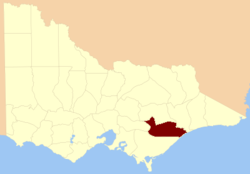
Location in VictoriaEstablished: 24 February 1871 Area: 7327 km² Lands administrative divisions around Tanjil Wonnangatta Wonnangatta Dargo Evelyn Tanjil Dargo Buln Buln Buln Buln Bass Strait The County of Tanjil (sometimes spelled Tangil) is one of the 37 counties of Victoria which are part of the cadastral divisions of Australia, used for land titles. It includes the coastal area around the Gippsland Lakes. The Mitchell River is the north-eastern boundary. Before the 1860s, the area was part of the former county of Bruce and part of Haddington.
Parishes
Parishes include:
- Bairnsdale, Victoria
- Baw Baw, Victoria
- Bengworden, Victoria
- Bengworden West, Victoria
- Binnuc, Victoria
- Boola Boola, Victoria
- Boole Poole, Victoria
- Bow-Worrung, Victoria
- Briagolong, Victoria
- Bullung, Victoria
- Bundalaguah, Victoria
- Bundowra, Victoria
- Butgalla, Victoria
- Colquhoun, Victoria
- Coongulla, Victoria
- Coongulmerang, Victoria
- Denison, Victoria
- Gillum, Victoria
- Glenaladale, Victoria
- Glenmaggie, Victoria
- Goon Nure, Victoria
- Koorool, Victoria
- Maffra, Victoria
- Marlooh, Victoria
- Meerlieu, Victoria
- Monomak, Victoria
- Moodarra, Victoria
- Moolpah, Victoria
- Moormurng, Victoria
- Moornapa, Victoria
- Nap-nap-marra, Victoria
- Narrang, Victoria
- Narrobuk, Victoria
- Narrobuk North, Victoria
- Nindoo, Victoria
- Numbruk, Victoria
- Nuntin, Victoria
- Sale, Victoria
- Sargood, Victoria
- Stratford, Victoria
- Tanjil, Victoria
- Tanjil East, Victoria
- Telbit, Victoria
- Tinamba, Victoria
- Toolome, Victoria
- Toombon, Victoria
- Toongabbie North, Victoria
- Toongabbie South, Victoria
- Wa-de-lock, Victoria
- Walhalla, Victoria
- Walhalla East, Victoria
- Winnindoo, Victoria
- Woolenook, Victoria
- Wooundellah, Victoria
- Worrowing, Victoria
- Wrathung, Victoria
- Wrixon, Victoria
- Wurruk Wurruk, Victoria
- Wurutwun, Victoria
- Yangoura, Victoria
- Yeerik, Victoria
- Yeerung, Victoria
References
- Vicnames, place name details
- Research aids, Victoria 1910
- Map of the county of Tanjil showing colony and parish boundaries, main roads, telegraph lines and railways. J. Sands, 1886, National Library of Australia
Counties of Victoria Anglesey • Benambra • Bendigo • Bogong • Borung • Bourke • Buln Buln • Croajingolong • Dalhousie • Dargo • Delatite • Dundas • Evelyn • Follett • Gladstone • Grant • Grenville • Gunbower • Hampden • Heytesbury • Kara Kara • Karkarooc • Lowan • Millewa • Moira • Mornington • Normanby • Polwarth • Ripon • Rodney • Talbot • Tambo • Tanjil • Tatchera • Villiers • Weeah • Wonnangatta
Categories:- Counties of Victoria (Australia)

Wikimedia Foundation. 2010.