- County of Rodney, Victoria
-
Rodney
Victoria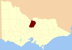
Location in VictoriaEstablished: 24 February 1871 Area: 4400 km² Lands administrative divisions around Rodney Gunbower Cadell (NSW) Moira Bendigo Rodney Moira Bendigo Dalhousie Moira The County of Rodney is one of the 37 counties of Victoria which are part of the cadastral divisions of Australia, used for land titles. It is located between the Goulburn River in the east, and the Campaspe River in the west, with a small part of the Murray River to the north. Puckapunyal is near its southern edge. There is the Electoral district of Rodney in a similar area.
Parishes
Parishes include:
- Bailieston, Victoria
- Bonn, Victoria
- Burnewang, Victoria
- Burramboot, Victoria
- Burramboot East, Victoria
- Campaspe, Victoria
- Carag Carag, Victoria
- Cherrington, Victoria
- Colbinabbin, Victoria
- Coomboona, Victoria
- Cornella, Victoria
- Corop, Victoria
- Crosbie, Victoria
- Dargile, Victoria
- Echuca North, Victoria
- Echuca South, Victoria
- Girgarre, Victoria
- Girgarre East, Victoria
- Gobarup, Victoria
- Kanyapella, Victoria
- Koyuga, Victoria
- Kyabram, Victoria
- Kyabram East, Victoria
- Moora, Victoria
- Mooroopna, Victoria
- Mooroopna West, Victoria
- Murchison, Victoria
- Murchison North, Victoria
- Muskerry, Victoria
- Nanneella, Victoria
- Noorilim, Victoria
- Redcastle, Victoria
- Rochester, Victoria
- Runnymede, Victoria
- Taripta, Victoria
- Timmering, Victoria
- Tongala, Victoria
- Toolamba, Victoria
- Toolamba West, Victoria
- Toolleen, Victoria
- Undera, Victoria
- Wanalta, Victoria
- Waranga, Victoria
- Weston, Victoria
- Whroo, Victoria
- Wirrate, Victoria
- Wyuna, Victoria
References
- Vicnames, place name details
- Research aids, Victoria 1910
- Cadastral map of the county of Rodney in Victoria showing parish and county boundaries and topographical features in explored areas. 1866, F.F. Bailliere. National Library of Australia
Counties of Victoria Anglesey • Benambra • Bendigo • Bogong • Borung • Bourke • Buln Buln • Croajingolong • Dalhousie • Dargo • Delatite • Dundas • Evelyn • Follett • Gladstone • Grant • Grenville • Gunbower • Hampden • Heytesbury • Kara Kara • Karkarooc • Lowan • Millewa • Moira • Mornington • Normanby • Polwarth • Ripon • Rodney • Talbot • Tambo • Tanjil • Tatchera • Villiers • Weeah • Wonnangatta
Categories:- Counties of Victoria (Australia)

Wikimedia Foundation. 2010.