- Tulsa Metropolitan Area
-
See also: Green Country
Tulsa Metropolitan Area
U.S. Census Bureau Areas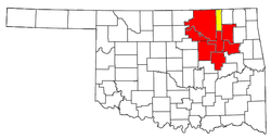
Tulsa Metropolitan Area[1] Common names Green Country, Tulsa Metro Area Population 937,478[2] Largest cities Tulsa, Broken Arrow, Owasso, Sapulpa, Bixby, Sand Springs, Claremore. Counties Tulsa, Rogers, Wagoner, Okmulgee, Creek, Pawnee, Osage. Density 151.8/sq. mi. (189.06/km²) Area 6,240 sq. mi. (16,164 km²) Tulsa-Bartlesville Combined Statistical Area[3] Population 988,454 in 2010.[4] Cities Bartlesville, and Dewey. Counties Washington. The Tulsa Metropolitan Area is a region in Northeastern Oklahoma with close economic, social, and cultural ties to the city of Tulsa and its urbanized area. The corresponding seven-county Metropolitan Statistical Area is the second-largest in Oklahoma and 53rd largest in the United States, containing 937,478 residents in 2010.[5] The Tulsa-Bartlesville Combined Statistical Area is formed with the addition of Washington County, bringing the area's population to 988,454 in 2010.[4] with projections to exceed one million sometime between 2010 and 2012.[6]
"Green Country" is a popular term used in different scenarios to describe different aspects of the Greater Tulsa Region, but may also refer specifically to the official Tulsa MSA. Each usage of the term is derived from its official meaning as the tourism designation for all of Northeastern Oklahoma. Its name was devised in the 1960s by the Oklahoma Department of Tourism and Recreation as one of six travel destination regions within the state, but is the most historically significant of all of them, as the name's usage can be traced to the early part of the 20th century. While the Tulsa MSA only officially occupies a section of Green Country as it is defined by the Oklahoma Department of Transportation, the entire region is sometimes referred to as the Greater Tulsa Area. On the same accord, the term "Green Country" often applies to the immediate Tulsa urban area or the city of Tulsa proper, but neither of these are technically the proper use for the term.
Contents
Cities
 Tulsa sits at the center of an initial ring of suburbs.
 Tulsa serves as the economic engine of the region.
 Broken Arrow is the region's second largest city.
 Bartlesville is the Tulsa-Bartlesville CSA's third largest city and the only outlining community with skyscrapers.
The Tulsa Metropolitan Area's anchor city, Tulsa, is surrounded by two primary rings of suburbs. Connected by suburban sprawl, the cityscapes of Tulsa and its initial outlying ring of suburbs form to make the immediate Tulsa Urban Area, an area that sits apart from a second ring of noncontiguous suburbs. Comprising the first ring of suburbs are: Catoosa, Bixby, Broken Arrow, Jenks, Owasso, Sand Springs, Sapulpa and Turley. Cities and towns in the second ring of suburbs include, Claremore, Okmulgee, Glenpool, Collinsville, Wagoner, Coweta, Skiatook, and Inola.
Largest Cities
Tulsa
Main article: Tulsa, OklahomaTulsa, home to 391,906 people in 2010,[7], is the principal cultural and economic hub of the Tulsa Metropolitan Area. The city, once known as the Oil Capital of the World, is still home to a large array of international oil-related industries, financial corporations, and manufacturing bases. The city contains the region's only private four-year universities, Oral Roberts University, and the University of Tulsa. The Tulsa International Airport and Tulsa Port of Catoosa serve as the region's primary international travel and shipping hubs.
Broken Arrow
Main article: Broken Arrow, OklahomaBroken Arrow is the metropolitan area's second largest city. According to the 2010 US Census, Broken Arrow has a population of 98,850 residents and is the fourth largest city in the state.[8] Though Broken Arrow contains a large base of industry and retail, it is a bedroom community of Tulsa. In 2007, the city was rated the safest city in Oklahoma and 20th safest in the nation, as well as one of the nation's 100 best places to live and one of the "Top 25 Affordable Suburbs in the South".[9]
Bartlesville
Main article: Bartlesville, OklahomaBartlesville is an Exurb of the city of Tulsa. With 38,750 people in 2010, the city is the third largest in the Tulsa-Bartlesvile Combined Statistical Area, though it is not considered part of the immediate Tulsa Statistical Area by the Census Bureau. It is the county seat of Washington County, and contains the only skyscraper built by famed architect Frank Lloyd Wright, the Price Tower. Oklahoma Wesleyan University, the only private four-year university in the outlying cities of the Tulsa regional area, is Bartlesville's primary institution of higher education.
Claremore
Main article: Claremore, OklahomaClaremore is an outer suburb of Tulsa. The population is estimated to be around 17,397. It is home to Rogers State University, a public four year university located on the city's west side. The city is home to many historical figures such as Will Rogers, a famous actor, Lynn Riggs, author of the novel that inspired the musical Oklahoma. Claremore is also the setting of the Oklahoma. Country singer Garth Brooks also lives just outside of Claremore. The Will Rogers museum is located in Claremore as well.
Owasso
Main article: Owasso, OklahomaOwasso, a bedroom community of 28,915 people in 2010, is the third largest city in the Tulsa Metropolitan Area and one of the fastest growing in the state. Situated just north of the Tulsa International Airport and the Tulsa Zoo in Tulsa and Rogers counties, the city is connected to Tulsa by Highway 169 and contains a large base of upscale retail.
Sand Springs
Main article: Sand Springs, OklahomaSand Springs, a diverse urban community is one of the oldest suburbs of Tulsa. The population was 18,906 in the 2010 U. S. Census. It is located along the Arkansas River, just five miles west of downtown Tulsa. It has a fast-growing residential population and is recognized as a hub of industrial activity. Attractions in Sand Springs include the Keystone Ancient Forest, Sand Springs Pogue Airport, the Canyons at Blackjack Ridge Golf Course and easy access to Keystone State Park. The city is connected to Tulsa by Highway 412/64, 41st Street and Avery Drive.
Sapulpa
Main article: Sapulpa, OklahomaSapulpa is home to The population was 20,544 at the 2010 United States census.[10], making it the fourth largest city in the Tulsa Metropolitan Area. The city is the county seat of Creek County.
Other Cities
North - Bartlesville, Owasso, Skiatook, Collinsville, Pawhuska, Dewey, Barnsdall
West - Sapulpa, Sand Springs, Bristow, Cleveland, Kellyville, Mannford
East - Broken Arrow, Claremore, Catoosa, Wagoner, Coweta, Inola
South - Jenks, Glenpool, Bixby, Mounds, Beggs, Okmulgee, Henryetta
Transportation
Interstate Highways and turnpikes
The Tulsa Metropolitan Area is heavily reliant on automobiles as a means of transportation. Interstate 44 (which runs northeast-southwest), U.S. Highway 75 (which runs north-south) and U.S. Highway 412 (which runs east-west) serve as the major thoroughfares of the region. Turnpikes play a vital role in the region's transportation system. The Will Rogers, Turner, Muskogee, Cimarron, and Creek turnpikes aide travel in the area.
Rail, seaport, and airport facilities
The area is home to the nation's farthest inland port, the Tulsa Port of Catoosa. This port, along with the Port of Muskogee, is situated along the McClellan-Kerr Arkansas River Navigation System, which helps in the shipment of goods to international trade routes. Several major rail lines are located throughout the region, although the Tulsa Metropolitan Area is one of the largest urban areas in the nation not served by Amtrak.[11] The region's principal airport is the Tulsa International Airport, which offers domestic passenger service. Other minor airports serving general aviation are located throughout the region.
Education
 Rogers State University in Claremore is the Tulsa Metropolitan Area's only four-year public university.
Common Education
The Tulsa Metropolitan Area, like much of the state of Oklahoma, is served by independent school districts. Each county contains several school districts and each school district is governed by a local school board. The region's largest school district is Tulsa Public Schools.[12]
Higher Education
The Tulsa metro is home to several colleges and universities. The Tulsa area's largest private schools are University of Tulsa and Oral Roberts University. Rogers State University is located in Claremore with branch campuses in Bartlesville and Pryor. Also, there are branch campuses of major state colleges, such as Oklahoma State University–Tulsa, University of Oklahoma-Tulsa and Northeastern State University in Broken Arrow. Tulsa Community College serves thousands of students as the region's primary junior college. Two medical schools are also located in the region: Oklahoma State University Center for Health Sciences and University of Oklahoma College of Medicine, where students serve out their last two years.
Economy
The Tulsa metropolitan area is the economic engine of eastern Oklahoma. The chief industries of the region are energy, aerospace, telecommunications, and manufacturing. Energy has long been a dominant player in the area's economy, as Tulsa was once dubbed the 'Oil Capital of the World'. Today, Fortune 500 energy companies still call the area home, such as ONEOK and Williams Companies. Also, a majority of American car rental companies are headquartered in the area, such as Fortune 1000 Dollar Thrifty Automotive Group.[13] There are major manufacturing and maintenance operations for the aerospace industry in Tulsa. The Tulsa region is home to the 8th best workforce in aerospace, 9th best in Energy and 18th best in telecommunications. In 2001, Tulsa metro's total gross product was in the top one-third of metropolitan areas, states, and countries globally, with more than $29 billion in total goods, expected to grow at a rate of nearly $500 Million every two years.[14]
Recreation and tourism
The area has several lakes and state parks. Major lakes include Keystone, Skiatook, Ft. Gibson, and Oologah. Popular state parks include Keystone Lake and Osage Hills.
The area contains two world renowned museums: Gilcrease and Philbrook, both in Tulsa. Museums focusing on western heritage draw visitors, such as Woolaroc and Will Rogers Memorial in Claremore.
Tallgrass Prairie Preserve is in Osage County, Oklahoma, near Foraker, Oklahoma.
References
- ^ Population Division, U.S. Census Bureau (December 2005). "Combined Statistical Areas and Component Core Based Statistical Areas, December 2005, With Codes". http://www.census.gov/population/estimates/metro_general/List6.txt.
- ^ Cite error: Invalid
<ref>tag; no text was provided for refs named2010pop; see Help:Cite errors/Cite error references no text - ^ Population Division, U.S. Census Bureau (December 2005). "Combined Statistical Areas and Component Core Based Statistical Areas, December 2005, With Codes". http://www.census.gov/population/estimates/metro_general/List6.txt.
- ^ a b "Annual Estimates of the Population of Combined Statistical Areas: April 1, 2000 to July 1, 2006" (xls). United States Census Bureau. University of Hawaii. http://www.hawaii.gov/dbedt/info/census/popestimate/2007_MSA_Hawaii/CBSA-EST2007-02.xls. Retrieved 2007-05-05.[dead link]
- ^ Morgan, Rhett (2008-03-27). "Stillwater's growth tops in Oklahoma". Tulsa World. http://www.tulsaworld.com/news/article.aspx?articleID=20080327_1_A9_hBein77115. Retrieved 2008-03-29.
- ^ Bell, Leigh (2007-04-05). "Metro Area growth nearing 7 digits". Tulsa World. http://www.tulsaworld.com/news/article.aspx?articleID=070405_1_A1_hThes35833. Retrieved 2007-04-13.
- ^ "Subcounty population estimates: Oklahoma 2000–2006" (CSV). United States Census Bureau, Population Division. 2007-06-28. http://www.census.gov/popest/cities/files/SUB-EST2006_40.csv. Retrieved 2008-05-06.
- ^ US Census Bureau. "U.S. Census Bureau Delivers Oklahoma's 2010 Census Population Totals". http://2010.census.gov/news/releases/operations/cb11-cn33.html. Retrieved 2010-04-16.
- ^ John Stancavage (6/8/2007). "Broken Arrow: Surging suburb". Tulsa World. http://tulsaworld.com/business/article.aspx?articleID=070608_238_E1_spanc37710. Retrieved 2007-06-15.
- ^ MuniNet Guide: Sapulpa, Oklahoma.[1]
- ^ How Well Does Amtrak Serve U.S. Cities?
- ^ TPS Attendance 10/06
- ^ 2007 Fortune 500-Oklahoma
- ^ "About Tulsa". Tulsa Metro Chamber. 2007. http://ww3.tulsachamber.com/general.asp?id=22. Retrieved 2007-06-08.
The City of Tulsa General Buildings · Climate · Education · Government · Famous Citizens · Geography · History · Mayors · Media · Transportation · Metropolitan AreaNeighborhoods 71st Street Corridor · Arkansas River · Brady Arts District · Blue Dome District · Brookside · Cherry Street · Downtown · East Tulsa · Greenwood · Midtown · North Tulsa · Red Fork · Southern Hills · Swan Lake · West Tulsa · Utica SquareLargest Suburbs Broken Arrow · Bartlesville · Sapulpa · Owasso · Sand Springs · Claremore · Bixby · Jenks · Glenpool · Coweta · Wagoner · Catoosa · CollinsvilleCategories:


Wikimedia Foundation. 2010.