- Dimla Upazila
-
Dimla
ডিমলা— Upazila — Location in Bangladesh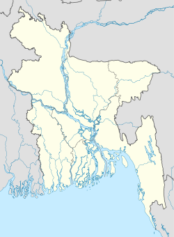
 Dimla
DimlaCoordinates: 26°7.7′N 88°55.5′E / 26.1283°N 88.925°ECoordinates: 26°7.7′N 88°55.5′E / 26.1283°N 88.925°E Country  Bangladesh
Division Rajshahi Division District Nilphamari District Area - Total 326.8 km2 (126.2 sq mi) Population (1991) - Total 187,696 - Density 574/km2 (1,486.7/sq mi) Time zone BST (UTC+6) Website Official Map of Dimla Dimla (Bengali: ডিমলা) is an Upazila of Nilphamari District in the Division of Rajshahi, Bangladesh.
Contents
Geography
Dimla is located at 26°07′40″N 88°55′30″E / 26.1278°N 88.9250°E . It has 36440 units of house hold and total area 326.8 km².
Demographics
As of the 1991 Bangladesh census, Dimla has a population of 187696. Males constitute are 51.24% of the population, and females 48.76%. This Upazila's eighteen up population is 91421. Dimla has an average literacy rate of 19.4% (7+ years), and the national average of 32.4% literate.[1]
Administrative
Dimla has 10 Unions/Wards, 53 Mauzas/Mahallas, and 53 villages.
Aministration
Chairman :
Women Vice Chairman :
Vice Chairman :
Upazila Nirbahi Officer (UNO): Mizanur Rahman
See also
References
- ^ "Population Census Wing, BBS.". Archived from the original on 2005-03-27. http://web.archive.org/web/20050327072826/http://www.bangladeshgov.org/mop/ndb/arpc91_v1/tables04.htm. Retrieved November 10, 2006.
2. http://www.thedailystar.net/newDesign/news-details.php?nid=185753
 Upazilas of the Rajshahi DivisionCapital: Rajshahi
Bogra District Adamdighi · Bogra · Dhunat · Dupchanchia · Gabtali · Kahaloo · Nandigram · Sariakandi · Sahajanpur · Sherpur · Shibganj · Sonatala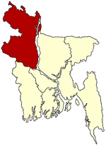
Joypurhat District Naogaon District Atrai · Badalgachhi · Dhamoirhat · Manda · Mahadevpur · Naogaon · Niamatpur · Patnitala · Porsha · Raninagar · SapapharNatore District Nawabganj District Pabna District Rajshahi District Sirajganj District Thakurgaon District Categories:- Upazilas of Nilphamari District
- Rajshahi Division geography stubs


Wikimedia Foundation. 2010.