- Carn a' Chlamain
-
Càrn a' Chlamain 
Càrn a' Chlamain seen from Glen Craoinidh to the southElevation 963 m (3,159 ft) Prominence c. 330 m Listing Munro, Marilyn Translation Hill of the kite or buzzard (Gaelic) Pronunciation Scottish Gaelic: [ˈkʰaːrˠn ə ˈxlˠ̪avɛɲ] Location Location Perth and Kinross,  Scotland
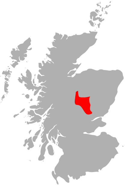
Range Grampians Topo map OS Landranger 43 OS grid NN916758 Càrn a' Chlamain (Gaelic: Càrn a' Chlamhain) is a Scottish mountain situated roughly 12 kilometres north of Blair Atholl in the Forest of Atholl. It is the highest point of an undulating plateau lying northeast of Glen Tilt. The River Tarf, a tributary of the Tilt, rises on the northwestern slopes before curving round the northern side of the plateau, whilst a further Tilt tributary marks the plateau's western boundary.
The summit of Càrn a' Chlamain is a prominent boulder covered dome rising up from the surrounding moorland.
The hill is almost invariably climbed from Glen Tilt. The most common route starts at Forest Lodge in Glen Tilt, from where a stalker's path climbs the steep side of the glen in a succession of zig-zags before crossing the plateau to the summit. As there is no public vehicular access to Forest Lodge the 10 kilometres from Old Blair must been undertaken on foot or bicycle.
One alternative route to the summit follows the southeast ridge; this may be joined about 3 km down the glen from Forest Lodge.
References
- The Munros (SMC Guide) Donald Bennett et al., ISBN 0907521312
Coordinates: 56°51′39″N 3°46′46″W / 56.86092°N 3.77948°W
 An Sgarsoch · An Socach ·
Beinn a' Ghlò - Bràigh Coire Chruinn-bhalgain, Càrn Liath and Càrn nan Gabhar
Beinn Dearg · Beinn Iutharn Mhòr · Càrn a' Chlamhain · Càrn a' Gheòidh · Càrn an Fhidhleir · Càrn an Rìgh
Càrn Aosda · Càrn Bhac · Glas Tulaichean · The Cairnwell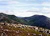 Categories:
- Munros
- Marilyns of Scotland
- Mountains and hills of the Eastern Highlands
- Mountains and hills of Perth and Kinross


Wikimedia Foundation. 2010.