- Greenwich Peninsula
-
Coordinates: 51°29′53″N 0°00′23″E / 51.498131°N 0.006317°E
Greenwich Peninsula 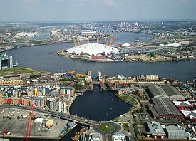
Greenwich Peninsula viewed from 1 Canada Square with the O2 entertainment complex in the centre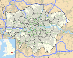
 Greenwich Peninsula
Greenwich Peninsula shown within Greater LondonOS grid reference TQ392796 London borough Greenwich Ceremonial county Greater London Region London Country England Sovereign state United Kingdom Post town LONDON Postcode district SE10 Dialling code 020 Police Metropolitan Fire London Ambulance London EU Parliament London UK Parliament Greenwich and Woolwich London Assembly Greenwich and Lewisham List of places: UK • England • London Greenwich Peninsula is an area of South London, England, located in the London Borough of Greenwich.
The peninsula is bounded on three sides by a loop of the Thames, between the Isle of Dogs and Silvertown. To the south is the rest of Greenwich, to the south-east is Charlton.
The peninsula lies within the London Borough of Greenwich. Formerly known as Greenwich Marshes[1] and as Bugsby's Marshes [2], it became known as East Greenwich as it developed in the 19th century, but has also been called North Greenwich due to the location of the North Greenwich tube station. This should not be confused with North Greenwich on the Isle of Dogs, at the north side of a former ferry from Greenwich. The peninsula's northernmost point on the riverside is known as Blackwall Point, and this may have led to the name Blackwall Peninsula sometimes being used in the late 20th century.[3]
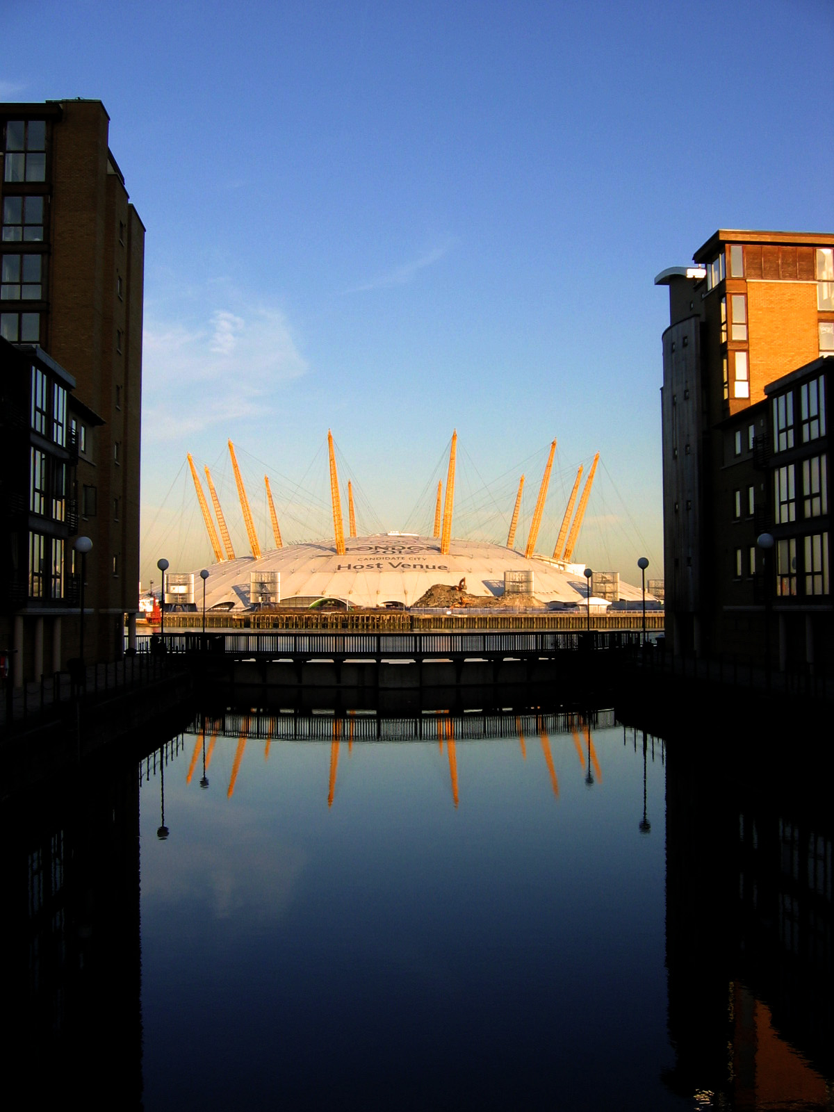
Landmarks include The Dome (also known by the current corporate logo The O2 and previously the Millennium Dome) and the southern end of the Blackwall Tunnel, but the area is now being substantially redeveloped with new homes, offices, schools, a college and parks.
Contents
History
 c1872 map of the Greenwich Peninsula and part of the Isle of Dogs
 The peninsula glimpsed from Greenwich Park in 1973. The view is framed on left and right by the chimneys of Greenwich Power Station and Blackwall Point Power Station
The peninsula was drained by Dutch engineers in the 16th century, allowing it to be used as pasture land. In the 17th century, Blackwall Point (the northern tip of the peninsula, opposite Blackwall) gained notoriety as a location where pirates' corpses were hung in cages as a deterrent to other would-be pirates.
The peninsula was steadily industrialised from the early 19th century onwards. In 1857 a plan was presented to Parliament for a huge dock occupying much of the peninsula, connected to Greenwich Reach to the west and Bugsby's Reach to the east, but this came to nothing.[4] Early industries included Henry Blakeley's Ordnance Works making heavy guns, with other sites making chemicals, submarine cables, iron boats, iron and steel.[1] Henry Bessemer built a steel works in the early 1860s to supply the London shipbuilding industry, but this closed as a result of a fall in demand due to the financial crisis of 1866.[5] Later came oil mills, shipbuilding (for example the 1870 clippers Blackadder and Hallowe'en built by Maudslay), boiler making, manufacture of Portland cement and linoleum (Bessemer's works became the Victoria linoleum works) and the South Metropolitan Gas company's huge East Greenwich Gas Works.[6] Early in the 20th century came bronze manufacturers Delta Metals and works making asbestos and 'Molassine Meal' animal feed.[7]
 The west side of the peninsula from the Thames in 2001 - part of the glucose works.
For over 100 years the peninsula was dominated by the gasworks which primarily produced town gas, also known as coal gas. The gasworks grew to 240 acres (0.97 km2), the largest in Europe, also producing coke, tar and chemicals as important secondary products. The site had its own extensive railway system connected to the main railway line near Charlton, and a large jetty used to unload coal and load coke. There were two huge gas holders, of 8.6 and 12.2 million ft3 (240,000m3 and 345,000m3). The larger holder, originally the largest in the world, was reduced to 8.9 million ft3 (250,000m3) when it was damaged in the Silvertown explosion in 1917, but was still the largest in England until it was damaged again by a Provisional Irish Republican Army bomb in 1978. Originally manufacturing gas from coal, the plant began to manufacture gas from oil in the 1960s. Its peak production of 400 million ft3 per day (11.3 million m3) in the mid 1960s is believed to have been the largest of any single site in the world.[8] The discovery of natural gas reserves in the North Sea soon rendered the complex obsolete.
On the eastern shore was Blackwall Point Power Station; the original station from the 1890s was replaced in the 1950s by a new station which ceased operation about 1981. A large area including the site of the Victoria linoleum works later became the Victoria Deep Water Terminal in 1966, handling container traffic.
At the southern end of the peninsula Enderby's Wharf was occupied by a succession of famous submarine cable companies from 1857 onwards, including Glass Elliot, W T Henley, Telcon, Submarine Cables Ltd, STC, Nortel and Alcatel.[9]
The peninsula remained relatively remote from central London until the opening of the Blackwall Tunnel in 1897, and had no passenger railway or London Underground service until the opening of North Greenwich tube station on the Jubilee Line in 1999.
Closure of the gasworks, power station and other industries in the late 20th century left much of the Greenwich Peninsula a barren wasteland, much of it heavily contaminated.
Surviving industrial uses today on the western side of the peninsula, between the river and the A102 Blackwall Tunnel southern approach road, include Alcatel, the recently closed (September 2009) Tunnel Refiners glucose plant (until about 2008 part of Tate & Lyle), and two large marine aggregate terminals on the Delta Metals and Victoria Deep Water Terminal sites. One of the two gas holders also remains.
Redevelopment since early 1990s
 The O2, the largest single-roofed structure in the world
Public and private investment since the early 1990s has brought about some dramatic changes in the Peninsula's topography. In 1997 the national regeneration agency, English partnerships, (now the Homes and Communities Agency) purchased 1.21 square kilometres (300 acres) of disused land on the Peninsula. The agency's investment of over £225m has helped to enhance the transport network and create new homes, commercial space and community facilities and to open up access to parkland along the river.
In addition to the construction of the Millennium Dome, new roads were built on the eastern side of the Peninsula in anticipation of new developments. New riverside walkways, cycle paths and public artworks were also created, including Antony Gormley's Quantum Cloud and A Slice of Reality the work by Richard Wilson.
The first two phases of Greenwich Millennium Village is an expanding residential development, with the Millennium Primary School, a medical centre, a nature reserve and associated education centre. A Holiday Inn hotel was also built nearby, and Greenwich Yacht Club was relocated to a new site east of the Dome.
North Greenwich tube station on the Jubilee Line opened in 1999. It is one of the largest London Underground stations and also has a bus station. The North Greenwich Pier offering commuter boat service to other parts of London, both east and west, is located on the Thames just to the east of the tube station.
In 2004 outline planning permission was granted for further large-scale redevelopment of the site, including over 10,000 further homes, some facing the river or overlooking the park, 3,500,000 square feet (330,000 m2) of office space and the conversion of the Millennium Dome into an indoor arena, renamed The O2. South of The O2, new public realm has been created, Peninsula Square and Green Place. To the east of Peninsula Square is Ravensbourne College, which relocated to Greenwich Peninsula in September 2010.[10] To the south east of the square, the six storey 14 Pier Walk building houses offices for Transport for London.[11] Adjacent to this is the 11 storey 6 Mitre Passage office building. New restaurants and shops have opened facing onto Peninsula Square and Green Place.
South of these developments is a large temporary building housing the London Soccer Dome,[12] formerly the David Beckham Academy. Approximately 400m further south, is the Pilot Inn public house, one of the oldest remaining buildings on the Peninsula.
Central Park runs through the central spine of the Peninsula, with the Greenwich Peninsula Ecology Park further south providing a haven for many different species of bird, plants and bugs.
Future development
The peninsula is now being developed with new homes at Peninsula Riverside, Parkside Peninsula Quays and the latest phase in construction at Greenwich Millennium Village. The former Millennium Dome, now The O2, will be a London 2012 venue. The present London Soccer Dome building will be a training facility for the 2012 games, after which the temporary building will be dismantled to make way for residential developments.
The redevelopment of Greenwich Peninsula is planned to take around 20 years. The improved access to the Peninsula from Canary Wharf, Silvertown, The City and Central London by the Jubilee Line has increased the prospects for continued residential regeneration.
This year, the Ravensbourne (college) new campus at Greenwich Peninsula won the Royal Institute of British Architects (RIBA) Awards for London 2011. From a shortlist of 55 schemes, the Ravensbourne (college) building won through in the education and community category in the ceremony hosted at the V&A.
Transport for London will be constructing a cable car over the River Thames for the 2012 Summer Olympics . This will run from a station close to the O2 at Greenwich Peninsula over the river to the Royal Victoria Dock.[13]
References
- ^ a b OS 1:2500 map of 1867, Republished as West India Docks 1867, The Godfrey Edition, Alan Godfrey Maps, 1991, Gateshead, ISBN 0-85054-466-1
- ^ http://www.theanswerbank.co.uk/History/Question687843.html
- ^ E.g. Hansard parliamentary reports: Simon Hughes in 1993 [1] and John Austin-Walker in 1994.[2]. Retrieved 24 April 2009
- ^ Mary Mills, Greenwich Marsh - The 300 years before the Dome, London: M.Wright, 1999, ISBN 0-953-54450-7
- ^ Bessemer's autobiography Chapter 21
- ^ OS 1:2500 map of 1894, Republished as West India Docks & Greenwich Marshes 1894, The Godfrey Edition, Alan Godfrey Maps, Gateshead, 2000, ISBN 9781841511948
- ^ OS 1:2500 map of 1914, Republished as West India Docks 1914, The Godfrey Edition, Alan Godfrey Maps, Gateshead, 1991, ISBN 0-85054-444-0
- ^ Carr, R.J.M. (Ed) 1983,Dockland, NELP/GLC, ISBN 0-7168-1611-3
- ^ Green A, 150 Years Of Industry & Enterprise At Enderby's Wharf
- ^ http://www.independent.co.uk/news/education/higher/the-shape-of-the-future-ravensbourne-college-764885.html
- ^ TfL begins move into new greener, cheaper Greenwich Peninsula offices, TfL press release, 13 August 2009
- ^ http://www.thelondonsoccerdome.com/
- ^ "Plans unveiled for a new Thames crossing with London's first cable car system". Transport for London. 4 July 2010. http://www.tfl.gov.uk/corporate/media/newscentre/archive/16125.aspx. Retrieved 13 June 2011.
Categories:- Geography of Greenwich
- Redevelopment projects in London
- Peninsulas of England
- Districts of London on the River Thames
- Port of London


Wikimedia Foundation. 2010.