- Craigendoran railway station
-
Craigendoran 
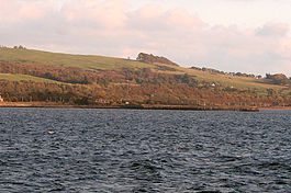
The derelict pier part of Craigendoran station, viewed from the River Clyde, with the North Clyde Line in the background on 13 October 2007 Location Place Helensburgh Local authority Argyll and Bute Coordinates 55°59′42″N 4°42′43″W / 55.995°N 4.712°WCoordinates: 55°59′42″N 4°42′43″W / 55.995°N 4.712°W Operations Station code CGD Managed by First ScotRail Number of platforms 1 Live arrivals/departures and station information
from National Rail EnquiriesAnnual rail passenger usage 2002/03 * 0.131 million 2004/05 * 0.149 million 2005/06 * 0.163 million 2006/07 * 0.159 million 2007/08 * 0.180 million 2008/09 * 0.201 million Passenger Transport Executive PTE SPT National Rail - UK railway stations A B C D E F G H I J K L M N O P Q R S T U V W X Y Z * Annual passenger usage based on sales of tickets in stated financial year(s) which end or originate at Craigendoran from Office of Rail Regulation statistics. Please note: methodology may vary year on year. Craigendoran railway station is a railway station serving Craigendoran, east of Helensburgh, Scotland.
The station is managed by First ScotRail and is served by trains on the North Clyde Line 37 km (23 mi) west of Glasgow Queen Street. West Highland Line trains no longer call at Craigendoran following the closure of the upper platforms.
Contents
History
At one time this station had five platforms: Two as an island platform on the West Highland Line - sometimes called Craigendoran Upper (now closed and singled), one on Craigendoran Pier serving Clyde Steamers (closed and lifted) and two on the line to Helensburgh (one closed when the line was singled). All bar the West Highland Line platforms are/were electrified.
The track layout at Craigendoran Junction was simplified in 1984. The present layout consists of a loop (available to West Highland Line trains only) and single lines to Helensburgh Upper and Helensburgh Central.
Signalling
Until 1937, Craigendoran had three signal boxes: Craigendoran East, Craigendoran Junction and Craigendoran West. The West box closed on 2 May 1937. On 28 March 1960, the East box closed and the remaining 'Craigendoran Junction' box was renamed 'Craigendoran'.
A replacement signal box, with an NX control panel, was opened on 4 November 1984. That signal box was itself closed in 1992, with control passing to Yoker Signalling Centre (IECC), which controls the whole North Clyde Line.
Services
There is a daily half-hourly service eastbound towards Glasgow Queen Street (and beyond) and westbound to Helensburgh Central.
Preceding station  National Rail
Following station Cardross First ScotRail
Helensburgh Central Historical railways Commencement of Line West Highland Railway Helensburgh Upper
Line and Station openCardross
Line and Station openGlasgow, Dumbarton and Helensburgh Railway Helensburgh Central
Line and Station openReferences
- Butt, R. V. J. (1995). The Directory of Railway Stations: details every public and private passenger station, halt, platform and stopping place, past and present (1st ed.). Sparkford: Patrick Stephens Ltd. ISBN 1-8526-0508-1. OCLC 60251199.
- Jowett, Alan (March 1989). Jowett's Railway Atlas of Great Britain and Ireland: From Pre-Grouping to the Present Day (1st ed.). Sparkford: Patrick Stephens Ltd. ISBN 1-8526-0086-1. OCLC 22311137.
- Yonge, John (May 1987). Gerald Jacobs. ed. British Rail Track Diagams - Book 1: ScotRail (1st edition ed.). Exeter: Quail Map Company. ISBN 0-9006-0948-6.
- Yonge, John (February 1993). Gerald Jacobs. ed. Railway Track Diagams - Book 1: Scotland and the Isle of Man (2nd edition ed.). Exeter: Quail Map Company. ISBN 0-9006-0995-8.
- Yonge, John (April 1996). Gerald Jacobs. ed. Railway Track Diagams - Book 1: Scotland and the Isle of Man (3rd edition ed.). Exeter: Quail Map Company. ISBN 1-8983-1919-7.
- Yonge, John (2007). Gerald Jacobs. ed. Railway Track Diagams - Book 1: Scotland & Isle of Man (Quail Track Plans) (fifth edition ed.). Bradford on Avon: "Trackmaps (formerly Quail Map Co)". http://www.trackmaps.co.uk.. ISBN 978-0-9549866-3-6. OCLC 79435248.
Categories:- Railway stations in Argyll and Bute
- Former North British Railway stations
- Railway stations opened in 1882
- Railway stations opened in 1894
- Railway stations closed in 1964
- SPT railway stations
- Railway stations served by First ScotRail

Wikimedia Foundation. 2010.