- Culburra Beach, New South Wales
-
Culburra Beach
New South Wales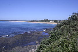
Northern end of Warrain Beach, the main surfing beach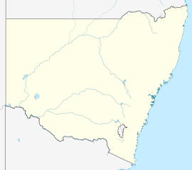
 Culburra Beach
Population: 2,910[1] Established: 1887 Postcode: 2540 Coordinates: 34°55′43″S 150°45′46″E / 34.9287°S 150.7629°ECoordinates: 34°55′43″S 150°45′46″E / 34.9287°S 150.7629°E Location: 18 km (11 mi) ESE of Nowra LGA: City of Shoalhaven State District: South Coast Federal Division: Gilmore Culburra Beach, commonly referred to as Culburra, is in the Shoalhaven region of New South Wales, Australia. It is 18 km east-southeast of Nowra on the South Coast. From the 2006 Census of Population and Housing, the town has a population of 2,910 and is the regional centre for the coastal villages of Currarong, Callala Beach, Callala Bay and Orient Point.
Description
Culburra is a small seaside town and a popular holiday, fishing and surfing location. Local industries include oysters, shrimp, and prawns. It has two surf beaches, Culburra Beach and Warrain Beach. The town is flanked by the Crookhaven River to the north and west, and Lake Wollumboola to the south. It is home to the Culburra Dolphins Rugby League team and the Culburra Cougars soccer team.
The town also boasts the two closest surf beaches to Nowra and is home to the Culburra Beach and Nowra Surf Club whose clubhouse is located at the northern end of Warrain Beach. The beaches are patrolled during the summer holiday period, and being located on either side of Penguin Head face in different directions, providing a variety of surf conditions for board riders, swimmers, body surfers and families with young children. A wide variety of fish species are caught on these beaches and from the rocky headlands adjacent to them.,[2]
History
Originally called Wheelers Point after the first landholder George Wheeler, the name was changed to Culburra in 1916 after an aboriginal word meaning "sand", and later to Culburra Beach. Postal services were first provided from Warrain Beach Post Office, which was renamed Culburra Beach in 1970.[3]
The area's first school was the Roseby Park Aboriginal School which opened in 1903. It became a public school in 1906 and remained that way until it closed in 1964. Culburra children had to attend Pyree Public School until its closure in August 1976, and the following month saw the opening of Culburra Public School.[citation needed]
The modern street plan of Culburra Beach was designed by Walter Burley Griffin, who also designed the street plan for Canberra.[citation needed]
References
- ^ Australian Bureau of Statistics (25 October 2007). "Culburra Beach (State Suburb)". 2006 Census QuickStats. http://www.censusdata.abs.gov.au/ABSNavigation/prenav/LocationSearch?collection=Census&period=2006&areacode=SSC16893&producttype=QuickStats&breadcrumb=PL&action=401. Retrieved 2008-03-29.
- ^ Culburra Beach has a place for everyone families, dogs, anglers and all budgets, writes Paul Myers. Sydney Morning Herald, May 2, 2009
- ^ "Name Search: WARRAIN BEACH". Geographical Names Board of New South Wales. http://www.gnb.nsw.gov.au/name_search/extract?id=SXIOWyrXSX.
South Coast, New South Wales Cities: Townships: Basin View · Batehaven · Batemans Bay · Bawley Point · Bega · Bemboka · Bermagui · Berry · Bodalla · Boydtown · Broulee · Callala Bay · Candelo · Cobargo · Congo · Culburra Beach · Dalmeny · Eden · Greenwell Point · Huskisson · Hyams Beach · Kianga · Kioloa · Lake Conjola · Malua Bay · Manyana · Merimbula · Milton · Mogo · Mollymook · Moruya · Mystery Bay · Narooma · Nelligen · Nerrigundah · Pambula · Pambula Beach · Potato Point · Pyree · Rosedale · Sanctuary Point · South Durras · St Georges Basin · Tathra · Tilba · Towamba · Tura Beach · Tuross Head · Ulladulla · Vincentia · Wandandian · Wolumla · WonboynLocal Government Areas: National Parks: Ben Boyd · Bournda · Biamanga · Budawang · Clyde River · Conjola · Deua · Eurobodalla · Gulaga · Jerrawangala · Kooraban · Mimosa Rocks · Monga · Morton · Mount Imlay · Murramarang · South East Forest · WadbilligaCategories:- Towns in New South Wales
- Towns in the South Coast, New South Wales
- Shoalhaven


Wikimedia Foundation. 2010.