- New Jersey Route 92
-
Route 92

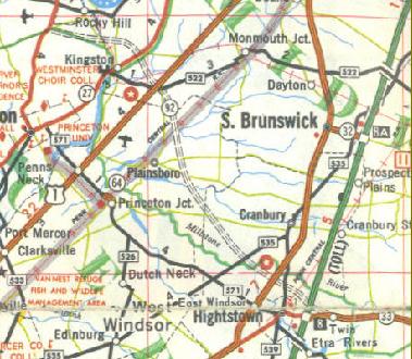
A map of Route 92 from US Army Corps of EngineersRoute information Maintained by NJDOT Length: 6.7 mi[1] (10.8 km)
Length of Route 92 post-1994 changes.Existed: 1950s – December 1, 2006 (never built) Major junctions West end:  US 1 in South Brunswick Township
 US 130 in South Brunswick Township
East end: 
 I-95 / NJ Turnpike in Monroe Township
Location Counties: Somerset, Middlesex, Mercer Highway system New Jersey State Highway Routes
Interstate and US←  Route 91
Route 93  →
→Route 92 was a 6.7-mile (10.8 km) proposed branch of the New Jersey Turnpike that would have run from west to east, beginning at U.S. Route 1 just north of Ridge Road (old CR 522) in South Brunswick Township, east along Route 32, to Exit 8A in Monroe Township. Prior to construction of Route 133, Route 92 was to follow part of its alignment around Hightstown before turning northwest and continuing beyond U.S. Route 1 to U.S. Route 206 and the never-built Somerset Freeway (Interstate 95).
Route 92 was also assigned in the 1953 renumbering and by the late 1950s it was named the Princeton–Hightstown Bypass, a freeway planned to connect the Somerset Freeway (an unbuilt section of Interstate 95) in Montgomery Township (near Skillman), with Route 33 in East Windsor Township (east of Hightstown). It was to be constructed and maintained by the NJDOT. As with the Somerset Freeway, local opposition kept the state from building the road. The Somerset Freeway was canceled in 1982, and in 1987 the planned Route 92 was truncated to only run east from U.S. Route 1 near Kingston. New plans were announced in 1994, this time running to US 1 near Princeton. After public hearings found opposition was still strong, the planned route was truncated to a much shorter bypass of Hightstown only and numbered Route 133. Construction on the road, the first project awarded under New Jersey's modified Design-build program, began on September 20, 1996. The full road was opened November 30, 1999.
The first plans for Route 92's new alignment, running from Exit 8A of the New Jersey Turnpike (rather than Exit 8) west to U.S. Route 206 near Rocky Hill, were made in 1988, using funds from the canceled Somerset Freeway. In 1992, the plans were formally transferred to the New Jersey Turnpike Authority, which announced the new plans in 1994, again dropping the segment west of US 1. All but $6.5 million of the $400 million project was reassigned in November 2005 to widen the Turnpike in southern New Jersey. On October 5, 2006, the United States Army Corps of Engineers in New York City released their "Final Environmental Impact Statement" regarding the spur. The statement did not make it clear that the Army Corps was approving the roadway; however, the report had hints of approval. Despite that, the Authority had already allocated most of the 92 funds to the widening of the turnpike between 8A and 6.
Contents
History
Princeton–Hightstown alignment
See also: New Jersey Route 133 and New Jersey Route 64 Route 64, a built portion of the original Route 31-A Freeway, which spawned Route 92
The first proposed alignments for a freeway from the borough of Princeton to the community of Hightstown originates in the designation of State Highway Route 31-A in 1938 by the New Jersey State Legislature.[2] Construction commenced on the new route, building a new bridge over the Pennsylvania Railroad a year later. This new, 104.00 feet (31.70 m) long bridge replaced the at-grade crossing on Washington Road,[3] which is now a dead-end.[4] When the state highway renumbering occurred on January 1, 1953, the new freeway proposals were designated as Route 92.[5] (Route 31-A was decommissioned at that point, and repealed from state law in 1992.[6]) The first assigned alignment of the Route 92 Freeway dates to the late 1950s, when the New Jersey State Highway Department as the Princeton-Hightstown Bypass, a new freeway to connect the Somerset Freeway (an unbuilt portion of Interstate 95 in the Montgomery Township community of Skillman) eastward to a junction with Route 33 in the community of East Windsor Township (east of Hightstown). This new freeway was to be constructed by the State Highway Department and maintained by the aforementioned corporation.[7] By 1967, the New Jersey Department of Transportation announced plans and although monetary issues stalled any forward movements, federal funding soon came in to help resume planning.[8]
 Route 133 heading westbound from the eastern terminus at Route 33. Route 133 was completed in 1999 as a project made separate from Route 92
The highway was proposed and received opposition from the communities of Princeton and Plainsboro, who cited destruction of open space and wetlands, which would reduce the quality of local life. In 1982, the Somerset Freeway was canceled as a project, and the $228 million (1982 USD) that came with it was given around by a partnership, with the New Jersey Department of Transportation suggesting the Route 92 Freeway become one of the six projects to receive funding. Final designs for the freeway were underway in 1986, amid controversy. As a result, the Department of Transportation dropped the section west of U.S. Route 1 in South Brunswick Township only a year later.[9] After plans for Route 92 were realigned northward in 1988, the Princeton-Hightstown Bypass was revived in 1994 for construction of a new bypass of Hightstown. This new, 3.8 miles (6.1 km) long freeway was designed under the Department of Transportation's first modified design-build program and construction commenced in 1996. The contractors in hire for the project were the Schaivone Construction Group, who set a bid for $57 million (1996 USD).[10] The new freeway, designated as Route 133 instead of Route 92, was opened in November 1999, ending the four-decade fight to construction freeway around Hightstown.[11] The delay occurred due to substantial erosion caused by the weakening Hurricane Floyd in 1999.[12]
Turnpike Extension alignment
See also: New Jersey Route 32 and County Route 522 (New Jersey)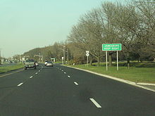 Route 130 northbound approaching the interchange with Route 32 in South Brunswick Township. Route 92's newer alignment was supposed to interchange with U.S. Route 130 here
In 1988, the New Jersey Department of Transportation realigned the proposed Route 92 Freeway off the Princeton-Hightstown Bypass to a route further north. This new alignment was to run from U.S. Route 206 near the community of Rocky Hill in Somerset County to Interchange 8A on the New Jersey Turnpike in Monroe Township in Middlesex County, using the alignment of Route 32 at its eastern terminus. The state cited that this new northerly alignment, funded by the cancellation of the Somerset Freeway, would serve better needs of the people.[13] In 1992, the proposal for Route 92 was turned over to the New Jersey Turnpike Authority from the Department of Transportation, citing the cost was too elevated. Two years later, the Turnpike Authority released new plans for the Route 92 alignment, this time creating a 6.7-mile (10.8 km) long limited-access highway from U.S. Route 1 in South Brunswick Township to Interchange 8A in Monroe Township. This new highway was to cost the Turnpike Authority $300 million (1994 USD). The opposition with the freeway shifted northward, with South Brunswick residents complaining the divide of their community. The environmentalists also cried foul on the destruction of 33 acres (130,000 m2) of wetlands and the encroachment on local open space. Giving their hands to these factors, the Environmental Protection Agency opposed this project twice during the 1990s, once in January 1997 and once in October 1998. The state did realign the proposals to reduce the loss of wetlands, and also proposed the addition of 57 new acres (230,000 m2) of wetlands. This proposal gained the support of the state's Department of Environmental Protection, but not the federal.[1]
 Promenade Boulevard, built as part of the Route 522 upgrade, a project to stop Route 92
In February 2000, the Turnpike Authority gave into the orders from the U.S. Army Corps of Engineers to have Route 92 undergo a environmental impact study, which could go up to two years to help see if they should award the contract for construction. Opponents of the Route 92 project hailed this decision for the thought that the environmental impact statement (EIS) would back up their beliefs.[14] Four months later, the Army Corps of Engineers held a meeting to decide what to take into account for the impact statement and held opinions from both the supporters and opposers of the freeway.[15] Around this time, locals sent an editorial to News 12 New Jersey to say that Middlesex County Route 522, already a four-lane freeway, should become the primary freeway across the portion of Middlesex County. However, the Turnpike Authority replied citing that Route 522 would be inadequate to handle the amount of traffic by 2015 that Route 92 was to handle.[16] In December 2003, the Army Corps of Engineers approved the statement and although, agencies still disagreed on the wetlands issues, held public hearings in 2004.[17]
To add insult to injury, in 2005, the Turnpike Authority relocated most of the Route 92 funding to the widening of the New Jersey Turnpike through the southern and central portions of New Jersey. The remaining funds, $6.5 million (2005 USD), left the project in limbo,[18] and the Army Corps of Engineers released a final statement, finding no other alternative outside of a new alignment.[19] On December 1, 2006, the New Jersey Turnpike Authority terminated its plans to build the spur from Ridge & 1 in South Brunswick to 8A in Monroe. Since most of the 92 funds had already been diverted to the Turnpike Authority's main concern, it made more sense to cancel the spur due to lack of funding. The Authority's main focus is widening the Turnpike between Exits 6 in Mansfield Township and 8A in Monroe Township in anticipation of increased traffic coming from the Pennsylvania Turnpike when modifications there are completed.[20]
Proposed alignments
 Right-of-way kept for the Route 92 Freeway at milepost 4 on Route 27 in Kingston, Somerset County
Princeton–Hightstown Bypass
The first alignment of the Route 92 Freeway, proposed in the 1950s, was to begin at an interchange with Interstate 95, known as the Somerset Freeway in the community of Skillman (in Montgomery Township). The route was supposed to head eastward, crossing an interchange with U.S. Route 206 in Montgomery Township before crossing over County Route 518 in Rocky Hill and interchanging with New Jersey Route 27 in Kingston. The route would then turn to the south and interchange with U.S. Route 1 and County Route 522 in the community of Monmouth Junction. From there, Route 92 would cross over the Pennsylvania Railroad to the north of New Jersey Route 64 in Plainsboro, turning to the southeast along the Millstone River. After crossing the Millstone, Route 92 was to interchange with County Route 535 in Cranbury before entering Hightstown, where it would interchange with U.S. Route 130. From there, the route would meet the New Jersey Turnpike at Interchange 8 before reaching its eastern terminus at an interchange with New Jersey Route 33 in Hightstown.[21]
Turnpike Extension alignment (post-1994)
On the turnpike extension alignment proposed in 1994, Route 92 was to begin at a trumpet interchange with U.S. Route 1 in South Brunswick. The interchange would have also served access to Middlesex County Route 683 (Schalks Crossing Road). The highway was to head to the southeast and cross under Perrine Road, which was proposed to have a brand new overpass and a westbound interchange. (There was also to be an eastbound entrance ramp from Perrine Road.) After curving to the east, Route 92 was to enter Plainsboro, cross the New Jersey Transit's Northeast Corridor Line and Devil's Brook, and then re-enter South Brunswick. The route was to continue eastward, passing to the north of McCormack Lake and begin following Friendship Road until the intersection with Miller Road. Route 92 was to turn to the southeast along with Friendship Road and cross through a toll station. It would have entered a large interchange with U.S. Route 130 and an access route to Friendship Road. Route 92's interchange with Route 130 was to be a cloverleaf interchange and from there, the highway was to follow current day Route 32 through Monroe Township. There, the highway was to continue southeastward, interchanging with local roads and continuing through an interchange with County Route 535 before merging into Interchange 8A with the New Jersey Turnpike, where Route 92 was to end.[22]
Proposed interchanges
Route 92 (Princeton-Hightstown)
County Location Mile Destinations Notes Somerset Skillman 0.0 I-95 (Somerset Freeway)Proposed western terminus of Route 92. Rocky Hill  US 206
Kingston  Route 27
Middlesex South Brunswick Township  US 1 / CR 522 (Ridge Road)
Cranbury  CR 535
Mercer Hightstown US 130 NJ TurnpikeInterchange 8 (NJ Turnpike)  Route 33
Proposed eastern terminus of Route 92 1.000 mi = 1.609 km; 1.000 km = 0.621 mi Route 92 (post-1994)
The entire route was in Middlesex County.
Location Mile[1] Destinations Notes South Brunswick Township 0.0 US 1Proposed western terminus of Route 92. 0.8 Perrine Road Westbound interchange only. 5.5 US 130 / Friendship RoadCloverleaf interchange. Monroe Township 6.7 I-95 / NJ TurnpikeInterchange 8A (NJTP/I-95); Proposed eastern terminus of Route 92 1.000 mi = 1.609 km; 1.000 km = 0.621 mi See also
 U.S. Roads portal
 New Jersey portal
References
- ^ a b c Epstein, Sue (March 30, 1999). "State Backs Plan for Hotly Debated Toll Road Linking Route 1 with Turnpike". The Star-Ledger.
- ^ ROUTE NO. 31A. Beginning in State highway route No. 31 in or near Princeton, and thence to a point at or near Hightstown and connecting there with State highway route No. 33 eastwardly of Hightstown., New Jersey State Assembly, 1938
- ^ United States Geological Survey (1909). Southeastern portion of the Princeton, New Jersey quadrangle (Map).
- ^ Google, Inc. Google Maps – Overview of old Route 31A (Map). Cartography by Google, Inc. http://maps.google.com/maps?f=d&source=s_d&saddr=&daddr=&hl=en&geocode=&mra=mr&ie=UTF8&ll=40.318189,-74.621437&spn=0.002646,0.006866&z=18. Retrieved August 27, 2009.
- ^ 1953 renumbering, New Jersey Department of Highways, http://en.wikisource.org/wiki/1953_New_Jersey_state_highway_renumbering, retrieved July 31, 2009
- ^ State of New Jersey, Laws of 1991, Page 1298, Section 2.
- ^ Regional Highways: Status Report. Tri-State Transportation Commission. 1962.
- ^ New Jersey Highway Facts. Ewing, New Jersey: New Jersey Department of Transportation. 1967.
- ^ Public Hearing for the Proposed Route 92 Freeway. Trenton, New Jersey: New Jersey Department of Transportation. December 17, 1991.
- ^ New Jersey's Modified Design-Build Program: Hightstown Bypass. Trenton, New Jersey, Washington D.C.: Federal Highway Administration, New Jersey Department of Transportation. June 1998.
- ^ Armone, Michael (December 1, 1999). "Long Wait is Over". Trenton, New Jersey: Trenton Times.
- ^ "Hightstown Bypass Opens to Traffic". Ewing, New Jersey: New Jersey Department of Transportation. November 29, 1999. http://www.state.nj.us/transportation/about/press/1999/112999b.shtm. Retrieved 7 January 2010.
- ^ Public Hearing for Proposed Route 92 Freeway. Trenton, New Jersey. New Jersey State Legislature.
- ^ Epstein, Sue (February 8, 2000). "Turnpike Consents to Study of Route 92". The Star-Ledger.
- ^ Raboteau, Albert (June 9, 2000). "Residents Voice Opinions on Route 92". Trenton, New Jersey: The Trenton Times.
- ^ Gross, Edward (August 11, 2000). "Highway 92: Editorial Reply". Edison, New Jersey: News 12 New Jersey.
- ^ DiMenichi, Sharlee Joy (December 31, 2003). "Army Completes Route 92 Draft". South Brunswick Township, New Jersey: The South Brunswick Post.
- ^ Tamari, Johnathan (November 30, 2005). "Route 92 Plan Loses Funding". The Asbury Park Press (Asbury Park, New Jersey: Gannett Newspapers).
- ^ Parker, Hillary (October 5, 2006). "Route 92 Report Is Puzzling to Many". South Brunswick Township, New Jersey: The South Brunswick Post.
- ^ "Route 92-turnpike connection project off the table -- for now: Official says expansion of turnpike between Exits 6 and 9 is the top priority". Morristown, New Jersey: Daily Record. December 2, 2006.
- ^ "New Jersey map with Route 92 inset". H.M. Gousha. 1976. http://www.nycroads.com/roads/NJ-92/img1.jpg. Retrieved 7 January 2010.
- ^ "Route 92 alignment map". Washington D.C.: United States Army Corps of Engineers. 2003. http://upload.wikimedia.org/wikipedia/en/c/c7/Rt_92.jpg. Retrieved 7 January 2010.
External links
Unbuilt Highways in New Jersey Interstate Highways I-695 • I-895State highways Toll roads and other highways Categories:- Transportation in Mercer County, New Jersey
- State highways in New Jersey
- Transportation in Middlesex County, New Jersey


Wikimedia Foundation. 2010.