- Chiltern, Victoria
-
Chiltern
Victoria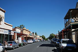
Main street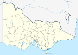
 Chiltern
Population: 1063 (2006)[1] Postcode: 3683 Location: LGA: Shire of Indigo State District: Benambra Federal Division: Indi Chiltern is a town in Victoria, Australia, located in the north east of the state between Wangaratta and Wodonga, in the Shire of Indigo. At the 2006 census, Chiltern had a population of 1063. The town is close to the Chiltern-Mount Pilot National Park. Chiltern was once on the main road between Melbourne and Sydney but is now bypassed by the Hume Freeway running one kilometre to the east.
Contents
History
The area of Chiltern was on the Wahgunyah cattle run and was known as Black Dog Creek. The township, named after the Chiltern Hills in England, was surveyed in 1853 but not established until gold discoveries in 1858-59 during the greater Victorian Gold Rush period. The Post Office opened on 1 September 1859 [2].
Many of Chiltern's buildings are classified by the National Trust. In 1859, many shop-keepers and miners from around Beechworth and the Ovens Valley districts followed the rush and re-located into Chiltern.
The Grape Vine Hotel, on the corners of Main Street and Conness Street, boasts the largest grapevine in Australia, planted in 1867.
Gold
 Lake View House at Chiltern, the home of author Henry Handel Richardson from July 1876 for 1½ years. Her early years at Chiltern featured in the novel The Fortunes of Richard Mahony.
 View of the lake from Lake View House. It was a swamp, not a lake, at the time the Richardson family lived in Chiltern. [1]
The discovery of gold in the late 1858 early 1859, brought a huge shift in population into the Chiltern - Black Dog Creek area. Gold discoveries drew many miners away from the nearby Ovens goldfields; namely Beechworth, Nine Mile Creek and Stanley during the big drought of 1859. Unlike those surfaced based sluicing mining operations around Beechworth, the gold around Chiltern was extracted by sinking deep wet leads. These operations required a diffent type of miner and working groups, capable of sinking shafts to some 400 feet in depth. Miners with these skills and experiences came into the area, from Ballarat and Bendigo and joined with the sluicers from around Beechworth and the Ovens. Miners from the Ballarat goldfields were considered 'radical', because of their connections with the Eureka Rebellion (1854). Some of these miners were colourful characters and the most notable, a colourful and radical A.A. O'Connor, stood for parliament in 1859 as the would-be member for the Ovens; his escapades and the social tensions his candidature aroused appear in O'Brien's book cited below.
While Beechworth's gold production declined during 1859, due in part to the drought and lack of water for sluicing, Chiltern's gold production increased (O'Brien), to such an extend that Chiltern looked as if it would usurp the importance of Beechworth. Beechworth was the most important regional centre in North-eastern Victoria during the gold boom 1852–1859. Chiltern did overshadow Beechworth within a few years, especially when the main Melbourne-Albury rail by-passed Beechworth. Finally, when the gold dwindled during the early 1900s, so did Chiltern.
The town today
The town hosts an antique fair in August and an art show in October. The Chiltern-Mount Pilot National Park lies close to the town.
Chiltern has an Australian Rules football team competing in the Tallangatta & District Football League.[3]
Golfers play at the Chiltern Golf Club on Howlong Road.[4]
The winning clip of the 2009 J Award for Best Music Video of the Year, Alex Roberts' video for Art vs. Science's Parlez-vous Français?, was entirely shot in this town.
Transport
The railway station is serviced by V/Line services running between Melbourne and Albury.
Notable people
- Mary Gaunt, novelist, was born here on 21 February 1861.
- John McEwen, 18th Prime Minister of Australia was born here on 29 March 1900.
- Chiltern was home for some time in her youth to Australian writer Ethel Richardson who wrote under the nom de plume Henry Handel Richardson, famous for her book The Getting of Wisdom.
- Nigel Lappin, Australian rules footballer grew up in Chiltern.
References
- ^ Australian Bureau of Statistics (25 October 2007). "Chiltern (State Suburb)". 2006 Census QuickStats. http://www.censusdata.abs.gov.au/ABSNavigation/prenav/LocationSearch?collection=Census&period=2006&areacode=SSC25341&producttype=QuickStats&breadcrumb=PL&action=401. Retrieved 1 October 2007.
- ^ Premier Postal History, Post Office List, https://www.premierpostal.com/cgi-bin/wsProd.sh/Viewpocdwrapper.p?SortBy=VIC&country=, retrieved 11 April 2008
- ^ Full Points Footy, Chiltern, http://www.fullpointsfooty.net/Chiltern.htm, retrieved 25 July 2008[dead link]
- ^ Golf Select, Chiltern, http://www.golfselect.com.au/armchair/courseView.aspx?course_id=949, retrieved 11 May 2009
- Robert W. P. Ashley, History of the Shire of Chiltern, Thompsons, Albury-Wodonga, 1974.
- Antony O'Brien, Shenanigans on the Ovens Goldfields: the 1859 Election, Artillery Publishing, Hartwell, 2005. (a mining candidate from Chiltern, A. A. O'Connor, stood for this general election during 1859)
- Jennifer Williams, Chiltern Standard Newspaper, 1859-60, M.A. Thesis, University of Melbourne, 1970. This is available in the Melbourne University Reading Room at the Baillieu Library.
- DNRE, Victorian Goldfield Project: Historical Gold Mining Sites in the North East Region of Victoria, 1999
External links
Coordinates: 36°09′00″S 146°36′25″E / 36.150°S 146.607°E
Towns in the Shire of Indigo Local Government Area Allans Flat · Baarmutha · Barnawartha · Beechworth · Chiltern · Indigo Valley · Kergunyah · Rutherglen · Stanley · Tangambalanga · Wahgunyah · Yackandandah
Categories:- Towns in Victoria (Australia)
- Mining towns in Victoria (Australia)


Wikimedia Foundation. 2010.