- Thunder Bay, Ontario
Infobox Settlement
name = City of Thunder Bay
nickname = (The) Lakehead; TBay
settlement_type =
total_type =
motto = Superior by Nature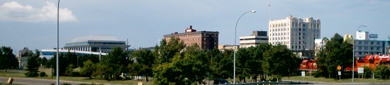
imagesize =
image_caption = Downtown Port Arthur in Thunder Bay
flag_size =
image_blank_emblem = Thunder_bay_logo.gif
blank_emblem_type = Logo
blank_emblem_size = 175px
image_dot_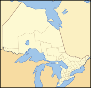
dot_mapsize = 250px
dot_map_caption = Location of Thunder Bay in Ontario
dot_x = 65 |dot_y = 138
subdivision_type = Country
subdivision_name =Canada flagicon|Canada
subdivision_type1 = Province
subdivision_name1 =Ontario flagicon|Ontario
subdivision_type2 = Region
subdivision_name2 =Northwestern Ontario
subdivision_type3 = District
subdivision_name3 = Thunder Bay District
subdivision_type4 = CMA
subdivision_name4 = Thunder Bay
government_footnotes = [http://www.thunderbay.ca/index.cfm?fuse=html&pg=29 City Hall] , Thunder Bay City Council. Retrieved on 2 June, 2007.] [http://www.thunderbay.ca/index.cfm?fuse=html&pg=768 Municipal Code] , by-law 218-2003. Retrieved on 2 June, 2007.]
government_type = Municipal Government
leader_title = Mayor
leader_name =Lynn Peterson
leader_title1 =City manager
leader_name1 =Tim Commisso Burkowski, Peter. " [http://www.chroniclejournal.com/top_story.php?id=129166 City appoints new city manager] ,"The Chronicle-Journal (19 August 2008 ). Retrieved19 August 2008 .]
leader_title2 = Governing Body
leader_name2 =Thunder Bay City Council
leader_title3 = MPs
leader_name3 =Ken Boshcoff (LPC)Joe Comuzzi (CPC)
leader_title4 = MPPs
leader_name4 =Michael Gravelle (OLP)Bill Mauro (OLP)
established_title = Settled
established_date = 1679 as Fort Caministigoyan
established_title2 = See histories of
established_date2 = Port Arthur and Fort William
established_title3 = Amalgamation
established_date3 =1 January ,1970
area_footnotes = [http://www12.statcan.ca/english/census06/data/profiles/community/Details/Page.cfm?Lang=E&Geo1=CSD&Code1=3558004&Geo2=PR&Code2=35&Data=Count&SearchText=thunder%20bay&SearchType=Begins&SearchPR=01&B1=All&Custom= City of Thunder Bay] , 2006 Community Profile. Statistics Canada. Retrieved on 2 June 2007.] [http://www12.statcan.ca/english/census06/data/profiles/community/Details/Page.cfm?Lang=E&Geo1=CMA&Code1=595__&Geo2=PR&Code2=35&Data=Count&SearchText=thunder%20bay&SearchType=Begins&SearchPR=01&B1=All&Custom= Thunder Bay CMA] , 2006 Community Profile. Statistics Canada. Retrieved on 2 June 2007.] [http://www.thunderbay.ca/docs/business/1173.pdf The Port of Thunder Bay] , The Transportation Sector. City of Thunder Bay. Retrieved on 30 November, 2007.]
area_total_km2 = 447.5
area_land_km2 = 328.5
area_water_km2 = 119.0
area_water_percent = 26.6
area_urban_km2 = 179.7
area_metro_km2 = 2550.4
area_blank1_title =
area_blank1_km2 =
elevation_footnotes =
elevation_m = 183
population_as_of = 2006
population_footnotes =City area] Metro area]
population_note =
population_total = 109140 (Ranked 43rd)
population_density_km2 = 332.3
population_metro = 122907 (Ranked 31st)
population_density_metro_km2 = 48.2
population_urban = 103247 (Ranked 29th)
population_density_urban_km2 = 574.5
population_blank1_title =Demonym
population_blank1 = Thunder Bayer
timezone = EST
utc_offset = −5
timezone_DST = EDT
utc_offset_DST = −4
latd=48 |latm=22 |lats=56 |latNS=N
longd=89 |longm=14 |longs=46 |longEW=W
postal_code_type = Postal code span
postal_code = P7A to P7G, P7J, P7K
area_code = 807
blank_name = NTS Map
blank_info = 052A06
blank1_name = GNBC Code
blank1_info = FCWFX
blank2_name =
blank2_info =
blank3_name =
blank3_info =
blank4_name =
blank4_info =
blank5_name =
blank5_info =
blank6_name =
blank6_info =
website = [http://www.thunderbay.ca City of Thunder Bay]Thunder Bay (2006 census population 109,140), formerly the twin cities of Fort William and Port Arthur, is a
city in and the seat of Thunder Bay District,Ontario ,Canada . It is the most populous municipality inNorthwestern Ontario , and the second most populous inNorthern Ontario afterGreater Sudbury . Thecensus metropolitan area of Thunder Bay has a population of 122,907, and consists of the city of Thunder Bay, the municipalities of Oliver Paipoonge and Neebing, the townships of Shuniah, Conmee, O'Connor and Gillies and theFort William First Nation .European settlement in the region began in the late 1600s with a French
fur trading outpost on the banks of theKaministiquia River . [http://www.thunderbay.ca/index.cfm?fuse=html&pg=313 Brief History of Thunder Bay] – Fort William and the Fur Trade – The North West Company. Retrieved on 5 June 2007.] The city was formed in 1970 by the merger of the cities of Fort William, Port Arthur and the geographic townships of Neebing and McIntyre. [ [http://www.thunderbay.ca/index.cfm?fuse=html&pg=313 Brief History of Thunder Bay] – Amalgamation. Retrieved on 5 June 2007.] Its port forms an important link in the shipping ofgrain and other products fromwestern Canada through the Great Lakes and theSaint Lawrence Seaway to the east coast.Forestry andmanufacturing play important roles in the city's economy, but with their decline in recent years they are being replaced by a "knowledge economy " based on medical research and education.The city takes its name from the immense bay at the head of
Lake Superior , known on 18th century French maps as "Baie du Tonnerre".See 3rd paragraph.] The city is often referred to as the "Lakehead" or "Canadian Lakehead" because of its location at the end of Great Lakes navigation.Tronrud, Thorold J; Epp, Ernest A.; and others. (1995). " [http://www.thunderbaymuseum.com/publications.htm Thunder Bay: From Rivalry to Unity] - Introduction and Acknowledgements", pp. vii.Thunder Bay Historical Museum Society ISBN 0-920119-22-0.]History
Before 1900
European settlement on Thunder Bay began with two French fur trading posts (1679, 1717) which were subsequently abandoned (see
Fort William, Ontario ). Permanent settlement began in 1803 with the establishment of Fort William by the Montreal-basedNorth West Company as its mid-continent entrepôt. The fort thrived until 1821 when the North West Company merged with theHudson's Bay Company and Fort William lost its raison d'être. By the 1850s theProvince of Canada began to take an interest in its western extremity, largely because of a demand for mining locations on the Canadian shores of Lake Superior following the discovery of copper in theKeweenaw Peninsula of Michigan. In 1849 French-speakingJesuits established the Mission de l'Immaculée-Conception (Mission of the Immaculate Conception) on the Kaministiquia to evangelize theOjibwe . The Province of Canada negotiated a treaty with theOjibwe of Lake Superior known as theRobinson Treaty in 1850. As a result, an Indian reservation was set aside south of the Kaministiquia River. In 1859–60 the Department of Crown Lands surveyed two townships (Neebing and Paipoonge) and the Town Plot of Fort William.Another settlement developed a few miles to the north of Fort William with the construction by the federal Department of Public Works of a road connecting Lake Superior with the
Red River Colony under the direction ofSimon James Dawson . (seePort Arthur, Ontario ) This public works depot or construction headquarters acquired its first name in May 1870 when ColonelGarnet Wolsley named it Prince Arthur's Landing. It was renamed Port Arthur by the CPR in May 1883. [F.B. Scollie, "Falling into Line : How Prince Arthur's Landing Became Port Arthur," Thunder Bay Historical Museum Society "Papers and Records", XIII (1985) 8-19.]The arrival of the
Canadian Pacific Railway in 1875 sparked a long battle for supremacy which did not end until the amalgamation of 1970. Until the 1880s, Port Arthur was a much larger and dynamic community, but the CPR in collaboration with the Hudson's Bay Company preferred east Fort William, located on the lower Kaministiquia river where the fur trade posts were. Further provoked by a prolonged tax dispute with Port Arthur and the seizure of alocomotive in 1889, the CPR relocated all its employees and facilities to Fort William. The collapse ofsilver mining after 1890 further undermined the economy of Port Arthur which entered a period of deep depression while Fort William thrived.The 20th century
Thunder Bay began a period of extraordinary growth in the era of Sir
Wilfrid Laurier as a result of transcontinental railway building and the western wheat boom. The CPR double-tracked its Winnipeg–Thunder Bay line. TheCanadian Northern Railway established facilities at Port Arthur. TheGrand Trunk Pacific Railway began construction of its facilities at the Fort William Mission in 1905, and the federal government began construction of theNational Transcontinental Railway .Grain elevator construction boomed as the volume of grain shipped to Europe increased. Both cities indebted themselves by granting bonuses to manufacturing industries. By 1914 the twin cities had modern infrastructures (sewers, safe water supply, street lighting, electric light, etc.) Both Fort William and Port Arthur were proponents of municipal ownership. As early as 1892 Port Arthur built Canada's first municipally-owned electric street railway, and both cities spurnedBell Telephone Company of Canada to establish their own municipally-owned telephone systems in 1902.The boom came to an end in 1913–14 aggravated by the First World War, but a war time economy emerged with the making of munitions and shipbuilding. The cities raised men for the 52nd, 94th and 141st Battalions of the
Canadian Expeditionary Force . Railway employment was hurt when the federal government took over theNational Transcontinental Railway and Lake Superior Division from the Grand Trunk in 1915, and the Canadian Northern Railway in 1918 which were amalgamated with other government-owned railways in 1923 to form theCanadian National Railways . The CNR closed many of the Canadian Northern Railway facilities in Port Arthur and opened the Neebing yards in Neebing Township in 1922. By 1929 the population of the two cities had recovered to pre-war levels.The forest products industry has always played an important role in the Thunder Bay economy from the 1870s. Logs and lumber were shipped primarily to the United States. In 1917 the first pulp and paper mill was established in Port Arthur. It was followed by a mill at Fort William in 1920. Eventually there were four mills operating.
Manufacturing resumed in 1937 when the Canada Car and Foundry Company plant re-opened to build aircraft for the British. Now run by
Bombardier Transportation , the plant has remained a mainstay of the post-war economy producing forestry equipment, then transportation equipment for urban transit systems such as theToronto Transit Commission andGO Transit .The expansion of highways beginning with the
Trans-Canada Highway culminating with the opening of a highway linking Sault Ste Marie to Thunder Bay has significantly diminished railway and shipping activity. TheSt Lawrence Seaway has not therefore lived up to expectations. Grain shipping has declined substantially in favor of Pacific Coast ports. As a result many grain elevators have been closed and demolished, and the Kaministiquia River has been abandoned by industry and shipping.Today
Thunder Bay has become the regional services centre for
Northwestern Ontario with most provincial departments represented.Lakehead University , established through the lobbying of local businessmen and professionals, has proved to be a major asset, reinforced byConfederation College . The same businessmen and professionals were the driving force behind the amalgamation of Fort William and Port Arthur in 1970.Government and politics
The city is governed by a mayor and twelve councillors. The mayor and five of the councillors are elected at large by the whole city. Seven councillors are elected for the seven wards: Current River Ward, McIntyre Ward, McKeller Ward, Neebing Ward, Northwood Ward, Red River Ward, and Westfort Ward. [ [http://www.thunderbay.ca/cityservices/index.cfm?fuse=ServiceDetails&thisservice=48 Guide to City Services] , Municipal Government, Wards. Retrieved on 4 June 2007]
Thunder Bay is represented in the Canadian Parliament by
Joe Comuzzi (Conservative) andKen Boshcoff (Liberal), and in theOntario Legislature byMichael Gravelle (Liberal) andBill Mauro (Liberal).Thunder Bay's name
Thunder Bay's name is the result of a
referendum held onJune 23 ,1969 to determine the new name of the amalgamated Fort William and Port Arthur. Officials debated over the names to be put on the ballot, taking suggestions from residents including "Lakehead" and "The Lakehead". Predictably, the vote split between the two, and "Thunder Bay" was the victor. The final tally was "Thunder Bay" with 15,870, "Lakehead" with 15,302, and "The Lakehead" with 8,377. [ [http://www.thunderbay.ca/docs/business/1012.pdf About Thunder Bay] , pp. 2. Retrieved on 2 September 2007.]City symbols
;Sleeping GiantA large formation of
mesa s on theSibley Peninsula inLake Superior which resembles a reclining giant has become a symbol of the city. Sibley peninsula partially encloses the waters of Thunder Bay, and dominates the view of the lake from the northern section of the city (formerly Port Arthur). The Sleeping Giant also figures on the city's coat of arms and the city flag.;Coat of armsThe
Coat of arms of Thunder Bay, Ontario is a combination of the coats of arms of both Port Arthur and Fort William, with a unifying symbol—the Sleeping Giant—at the base of the arms. [http://www.thunderbay.ca/index.cfm?fuse=html&pg=49 Thunder Bay City Symbols] . Retrieved on 4 June 2007.];Corporate logoThe city logo depicts a stylized thunderbird, called Animikii, a statue of which is located on the city's Kaministiquia River Waterfront Park. The slogan, "Superior by Nature", is a double play on words reflecting the city's natural setting on Lake Superior...]
;City flagThunder Bay's
flag was created in 1972, when mayorSaul Laskin wanted to promote the city by having a distinctive flag. The city held a contest, which was won by Cliff Redden. The flag has a 1:2 ratio, and depicts a golden sky from the rising sun behind the Sleeping Giant, which sits in the blue waters of Lake Superior. The sun is represented by a redmaple leaf , a symbol of Canada. Green and gold are Thunder Bay's city colours...]Sister cities
Thunder Bay has five sister cities on three continents, [ [http://www.thunderbay.ca/index.cfm?fuse=html&pg=301 Thunder Bay Sister Cities] . Retrieved on 11 August 2007] which are selected based on economic, cultural and political criteria.
*
Seinäjoki ,Finland since 1974
* Little Canada,Minnesota since 1977
* Duluth,Minnesota since 1980
*Keelung , Taiwan since 1988
* Gifu,Japan since 2007Geography
The city has an area of 328.48 square kilometres which includes the former cities of Fort William and Port Arthur as well as the townships of
Neebing, Ontario and McIntyre.The former Fort William section occupies flat
alluvial land along theKaministiquia River which has ariver delta at its mouth of two large islands known as Mission Island and McKellar Island. The former Port Arthur section is more typical of theCanadian Shield , with gently sloping hills and very thin soil lying on top of bedrock with many bare outcrops. Thunder Bay, which gives the city its name, is immense—about 22.5 kilometres (14 miles) from the Port Arthur downtown to Thunder Cape at the tip of the Sleeping Giant.The city reflects the settlement patterns of the 19th century. It is therefore highly spread out for historical reasons. Anchoring the west end of the city, the Fort William Town Plot surveyed in 1859–60 was named West Fort William (Westfort) in 1888 by the CPR. The land adjoining the lower Kaministiquia River became the residential and central business district of the town and city of Fort William. A large uninhabited area adjoining the Neebing and McIntyre rivers which became known as Intercity separated Fort William from the residential and central business district of Port Arthur. At the extreme east of the city, a part of McIntyre Township was annexed to the town of Port Arthur in 1892, forming what later became known as the Current River area.
Since 1970, the central business districts of Fort William and Port Arthur have suffered a serious decline as business and government have relocated to the Intercity area. There has also been substantial residential growth in adjacent areas of the former Neebing and McIntyre townships.
Climate
The climate of Thunder Bay and area is influenced by Lake Superior, which is especially noticeable in the city's north end, resulting in cooler summer temperatures and warmer winter temperatures for an area extending inland as far as 16 km. The average daily temperatures range from a high of 17.6 °C in July and a low of -14.8 °C in January. The average daily high in July is 24.2 °C and the average daily high in January is -8.6 °C. On January 10, 1982, the local temperature in Thunder Bay dropped to -36 °C, with a wind speed of 54 km/h for a wind chill temperature that dipped to -58 °C. As a result, it holds Ontario's record for coldest day with wind chill. [ [http://www.on.ec.gc.ca/severe-weather/winterwx_factsheet_e.html Ontario Region Winter Weather Factsheet] , Environment Canada. Retrieved on 11 April 2008] The city is quite sunny with an average of 2167.7 hours of bright sunshine each year, ranging from 283.4 hours in July to 88.8 hours in November, sunnier than any city in Canada located to the east of it. [ [http://www.climate.weatheroffice.ec.gc.ca/climate_normals/results_e.html?Province=ALL&StationName=thunder%20bay&SearchType=BeginsWith&LocateBy=Province&Proximity=25&ProximityFrom=City&StationNumber=&IDType=MSC&CityName=&ParkName=&LatitudeDegrees=&LatitudeMinutes=&LongitudeDegrees=&LongitudeMinutes=&NormalsClass=A&SelNormals=&StnId=4055& Canadian Climate Normals] , Thunder Bay A, Ontario. Environment Canada. Retrieved on 4 June 2007]
The rising cost of electricity in Ontario has threatened the viability of
primary industries in the region, resulting in the laying off of workers at pulp and saw mills. The grain trade has declined because of the loss of grain transportation subsidies and the loss of European markets. The gradual transition from shipping by train and boat to shipping by truck, and theCanada-United States Free Trade Agreement have ended Thunder Bay's privileged position as alinchpin in Canadian east-west freight-handling trade. As a result the city has lost its traditionalraison d'être as a break-bulk point, and the city is in economic decline.In an effort to rejuvenate its economy, the city has been actively working to attract quaternary or "knowledge-based" industries, primarily in the fields of
molecular medicine andgenomics . [" [http://www.tbrhsc.com/patient_information/media_releases/molecular_medicine_research_centre_celebrated.asp New Molecular Medicine Research Centre to be Headquartered in Thunder Bay] , TBRHSC.com" (6 September 2006 ). Retrieved on4 September 2007 ] [ [http://www.genesisgenomics.com/ Genesis Genomics] . Retrieved on2 September 2007 .] The city is home to the western campus of theNorthern Ontario School of Medicine , the first medical school to open in Canada in a generation." [http://www.siteselection.com/features/2005/nov/ont/pg02.htm Thunder Bay Blends Old, New Industries] , Site Selection" (November 2005). Retrieved on4 September ,2007 ]Infrastructure
Transportation
Thunder Bay receives air, rail and shipping traffic due to its prime location along major continental transportation routes. Greyhound Canada provides coach service to both regional and national destinations, with the municipally owned
Thunder Bay Transit providing 17 routes across the city's urban area. The city is served by theThunder Bay International Airport , the fourth busiest airport in Ontario by aircraft movements. [ [http://www.tc.gc.ca/pol/en/report/TP1496/pdf/2006/51F0010PIE2006000.pdf TP 1496 Preliminary aircraft statistics 2006] . Transport Canada. Retrieved on 2 September 2007.] The main highway through the city is Highway 11/17, a four lane highway designated as theThunder Bay Expressway .The city is an important railway hub, served by both the Canadian National and
Canadian Pacific Railway. Passenger rail service to Thunder Bay ended on15 January ,1990 , with the cancellation ofVIA Rail 's southern transcontinental service. [Canada Transportation Act, 1990. [http://www.tc.gc.ca/acts-regulations/GENERAL/c/ct/regulations/020/ct024/ct24.html#SCHEDULE%20III Order Varying Certain National Transportation Agency Orders Respecting Railway Companies] , SOR/89-488 S III 1. (2) (c). Retrieved on 5 June 2007];Harbour
Thunder Bay has been a port since the days of the
North West Company which maintained a schooner on Lake Superior. The Port of Thunder Bay is the largest outbound port on the St. Lawrence Seaway System, [ [http://www.portofthunderbay.ca/ Port of Thunder Bay] , official website. Retrieved on 2 September 2007.] and the sixth largest port in Canada." [http://www.siteselection.com/features/2005/nov/ont/pg02.htm Thunder Bay Blends Old, New Industries] , Site Selection" (November 2005). Retrieved on4 September ,2007 ] The Thunder Bay Port Authority manages Keefer Terminal, built on a 320,000 square metre site on Lake Superior.Medical centres and hospitals
Thunder Bay has one major hospital, the
Thunder Bay Regional Health Sciences Centre . Other health care services include the St. Joseph's Care Group, which operates long term care centres such as the Lakehead Psychiatric Hospital, St. Joseph's Hospital, and Hogarth Riverview Manor. TheNorthern Ontario School of Medicine has a campus at Lakehead University. The city is also home to a variety of smaller medical and dental clinics.Population and demographics
Media
Print
Thunder Bay has one daily newspaper, "
The Chronicle-Journal ", which has a circulation of approximately 28,000 and has coverage of all of Northwestern Ontario. [ [http://www.netnewsledger.com/index.php?option=com_content&task=view&id=1358&Itemid=2 Sudbury Star and Sault Star Part of Media Buyout] . Netnewsledger, 1 June 2007. Retrieved on 8 June 2007.] There are two weekly news papers—"Thunder Bay's Source ", a weekly newspaper operated by Dougall Media, and "Canadan Sanomat ", aFinnish language weekly newspaper.Lakehead University has a student newspaper called "The Argus", which is published weekly during the school year. [ [http://argus.theorem.ca/index.php?view=section&iid=9457&sid=1 The Argus] . Retrieved on 8 June 2007] The Chronicle Journal publishes a free weekly called "Spot" every Thursday, focusing on entertainment. The city produces a bi-monthly publication to citizens titled "yourCity", which is also available online in a PDF format. [ [http://www.thunderbay.ca/index.cfm?fuse=html&pg=1128 Your City] , Thunder Bay. Retrieved on 2 September 2007.] "Netnewsledger" is a daily updated website covering news and current events in Thunder Bay, which places emphasis on connecting politicians to their constituents. [http://www.netnewsledger.com Netnewsledger home page] . Retrieved20 January 2008 .]Television
Three English language stations and one French language station supply Thunder Bay with free
over-the-air television. CTV and CBC service is provided by a locally-ownedtwinstick operation branded asThunder Bay Television , and the city receivesTVOntario on channel 9 and the FrenchCBLFT-TV on channel 12.The cable provider in Thunder Bay is Shaw. The community channel on Shaw Cable is branded as
Shaw TV , and airs on cable channel 10.Radio
Thunder Bay is home to 11 radio stations, all of which broadcast on the FM band.
There are four commercial radio stations based in the city — Rock 94.3 and CKPR 91.5, owned by
Dougall Media , the parent company of Thunder Bay Television and "Thunder Bay's Source", and Magic 99.9 and 105.3 The Giant, owned byNewcap Broadcasting . One additional station, Thunder 103.5, targets the Thunder Bay market from transmitters in Kaministiquia and Shuniah. The city receivesCBC Radio One asCBQT-FM andCBC Radio 2 asCBQ-FM , at 88.3 FM and 101.7 FM respectively. The FrenchPremière Chaîne is available as a repeater of Sudbury-basedCBON-FM on 89.3 FM. Lakehead University operates a campus radio station,CILU-FM , at 102.7 FM, and CJOA-FM 95.1 broadcasts Christian-oriented programming and is run by a local non-profit group.Notable natives
Thunder Bay is home to a wide variety of notable people. Some of the best known living persons are
Paul Shaffer ,bandleader on the American "Late Show with David Letterman ", [ [http://www.cbs.com/latenight/lateshow/show_info/bios/cast06.php Paul Shaffer Bio at CBS - Late Show] . Retrieved on 20 April 2007.] andBobby Curtola , an earlyrock and roll singer and one-timeteen idol , [ [http://www.curtola.com/ Curtola's Official Website] . Retrieved on 20 April 2007.] both of whom have streets named after them. Notable athletes include NHL players (and brothers)Eric Staal ,Marc Staal ,Jordan Staal , [ [http://www.hockeydb.com/ihdb/stats/pdisplay.php3?pid=55283 Eric Staal] at [http://www.hockeydb.com/ The Internet Hockey Database] . Accessed on20 April 2007 .] Olympic gold medalistKatie Weatherston , professionalBMX rider and 9-timeX-Games medalistJay Miron , [ [http://www.allamericanspeakers.com/celebritytalentbios/Jay-Miron Printable Biography of Jay Miron] , "All-American Talent and Celebrity Network". Retrieved on2 October 2007 .] andVampiro , the top Canadian wrestler on Mexico'slucha libre circuit. [ [http://www.onlineworldofwrestling.com/profiles/v/vampiro.html Profile] at "Online World of Wrestling". Retrieved 20 April 2007.]Clarence Decatur Howe , originally from Massachusetts, moved to Canada in his early adult years and, as "Minister of Everything" played a major role in the economic development of Canada. [ [http://www.parl.gc.ca/information/about/people/key/bio.asp?lang=E&query=2936&s=M Federal Experience] . "Parlinfo" Parliamentarian file. Retrieved 20 April 2007.]Bora Laskin , brother of the city's first mayorSaul Laskin , was the Chief Justice of theSupreme Court of Canada from 1973 to 1984. [ [http://www.scc-csc.gc.ca/AboutCourt/judges/laskin/index_e.asp Official Biography] , Supreme Court of Canada website. Retrieved on 20 April 2007.]Elizabeth Lawrie Smellie was anurse , and the first woman to be promoted to the rank ofcolonel in the Canadian army. [MacLean, Mary R. Colonel Elizabeth Smellie CBE,Thunder Bay Historical Museum Society, Papers and Records, III (1975), 16–18 with reproduction of portrait by Kenneth Forbes on page 16.]Surrounding municipalities
Canadian City Geographic Location (8-way)
Northwest = Kaministiquia
North = Thunder Bay, Unorganized
Northeast = Dorion, Nipigon, Red Rock, Shuniah
West = Conmee, O'Connor, Oliver Paipoonge
Centre = Thunder Bay
East = "Thunder Bay,Sibley Peninsula "
Southwest = Gillies, Nolalu
South =Fort William First Nation , Neebing
Southeast = "Isle Royale "Notes and references
*Thorold J. Tronrud and A. Ernest Epp (1995) "Thunder Bay: From Rivalry to Unity", [http://www.thunderbaymuseum.com/publications.htm#tbrival Thunder Bay Historical Museum Society] , ISBN 0-920119-20-4
External links
* [http://www.thunderbay.ca City of Thunder Bay Official Website]
* [http://www.visitthunderbay.com City of Thunder Bay Official Tourism Website]
* [http://www.tb-chamber.on.ca/ Thunder Bay Chamber of Commerce]
* [http://www.tbairport.on.ca Thunder Bay International Airports Authority]


Wikimedia Foundation. 2010.