- Lede, Belgium
-
Lede 

Flag
Coat of armsLocation in Belgium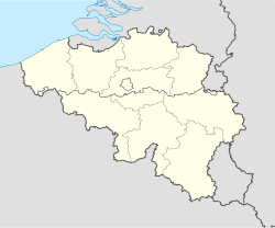
 Lede, Belgium
Coordinates: 50°58′N 03°59′E / 50.967°N 3.983°E Country Belgium Region Flemish Region Community Flemish Community Province East Flanders Arrondissement Aalst Government – Mayor Geert Grepdon (VLD) – Governing party/ies VLD, CD&V Area – Total 29.69 km2 (11.5 sq mi) Population (1 January 2010)[1] – Total 17,629 – Density 593.8/km2 (1,537.9/sq mi) Postal codes 9340 Area codes 053, 09 Website www.lede.be Map of Lede, Belgium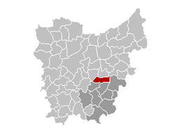
- This article is about the Belgian municipality. For other uses see Lede (disambiguation)
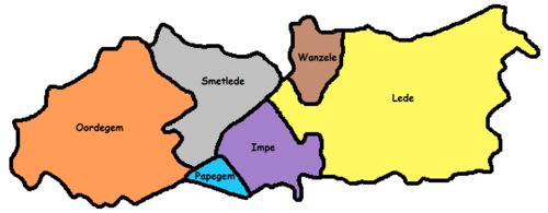
Lede is a municipality located in the Belgian province of East Flanders in the Denderstreek, nearby cities are Gent, Aalst and Dendermonde. The municipality comprises the towns of Impe, Lede proper, Oordegem, Smetlede, Wanzele and Papegem. In 2011, Lede has a total population of 17,882 [2]. The total area is 29.69 km² which gives a population density of 575 inhabitants per km². The current mayor of Lede is Geert Grepdon, from the VLD (Liberal) party.
Lede is known for a specific statue of St-Mary, "Onze-Lieve-Vrouw-van-Zeven-Smarten" (Our Lady of the Seven Sorrows), to which a local myth attributes magical powers, making Lede into a local pilgrimage destination. The statue is taken around in a procession during a Sunday in June, after the biannual nine-day festival. The local church, built in 1496, houses the statue. The abandoned Castle of Mesen is situated in central Lede. Its destruction has been started in April of 2010.
References
External links
Municipalities in the Province of East Flanders, Flanders, Belgium Aalst Aalst · Denderleeuw · Erpe-Mere · Geraardsbergen · Haaltert · Herzele · Lede · Ninove · Sint-Lievens-Houtem · Zottegem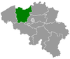
Dendermonde Berlare · Buggenhout · Dendermonde · Hamme · Laarne · Lebbeke · Waasmunster · Wetteren · Wichelen · ZeleEeklo Ghent Aalter · Deinze · De Pinte · Destelbergen · Evergem · Gavere · Ghent · Knesselare · Lochristi · Lovendegem · Melle · Merelbeke · Moerbeke · Nazareth · Nevele · Oosterzele · Sint-Martens-Latem · Waarschoot · Wachtebeke · Zomergem · ZulteOudenaarde Brakel · Horebeke · Kluisbergen · Kruishoutem · Lierde · Maarkedal · Oudenaarde · Ronse · Wortegem-Petegem · Zingem · ZwalmSint-Niklaas Categories:- Lede, Belgium
- Municipalities of East Flanders
- East Flanders geography stubs


Wikimedia Foundation. 2010.