- U.S. Route 19W
-
This article is about the section of U.S. Route 19W. For the entire length of the highway, see U.S. Route 19.
U.S. Route 19W
Route information Length: 63 mi[1] (101 km) Existed: 1930 – present Major junctions South end: 
 US 19 / US 19E in Cane River, NC
 I-26 / US-23 near Erwin, TN
North end:  US-11E / US-19 / US-19E near Bluff City, TN
Location Counties: Yancey, NC, Unicoi, TN, Washington, TN, Sullivan, TN Highway system United States Numbered Highways
List • Bannered • Divided • ReplacedU.S. Route 19W (aka US 19 West) traverses approximately 63 miles (101 km) from Cane River, North Carolina to Bluff City, Tennessee.
Contents
Route description
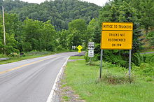 Start of US 19W North (2011-07-16).
US 19W begins in western Yancey county at the community of Cane River, at the intersection of US 19/US 19E. Several signs at the beginning of the route strongly recommend truckers against using this route. The road then proceeds north through the Pisgah National Forest, connecting the communities of Elk Shoal, Ramseytown and Sioux, to the Tennessee state line (near Spivey Gap); a 22 miles (35 km) drive of endless curves and elevation changes.
Once past the state line, the road enters the Cherokee National Forest, however the road is still much the same for another 6.3 miles (10.1 km) to SR-352/Flag Pond Road. From Flag Pond Road, it is just 1 mile (1.6 km) to Interstate 26, where US 19W merges with to Johnson City. US 19W overlaps with I-26/US 23 from exit 43 (Hill Road) to exit 20 (Roan Street). It leaves I-26, overlapped with US 11E continues north on the Bristol Highway for 9.4 miles (15.1 km), where reconnects with US 19E to reform US 19 near Bluff City.
History
Established in 1930, US 19 was split, at Cane River, into US 19E and US 19W. US 19E follows the original US routing via Spruce Pine and Elizabethton to Bluff City. US 19W was routed an alternate route with US 23 and NC 692 into Tennessee, then through the cities Erwin and Johnson City, before rejoining US 19E in Bluff City. In late 1934, NC 692 was dropped along route; then in 1952, US 23 abandoned US 19W in North Carolina by rerouting west through Faust and Wolf Laurel, meeting back at Ernestville. In 1984, US 19 was realigned on a more straight path in Yancey County, US 19W was thus extended .4 miles (0.64 km).[2][3]
North Carolina Highway 692
Established in 1923 as new primary routing to Tennessee, NC 692 was the original highway number from Cane River to Spivey Gap. In 1929, NC 692 was truncated at Sioux, replaced by an extension of NC 19 from Bakersville. In 1930, US 19W and US 23 were overlapped on the remaining section of NC 692. In late 1934, NC 692 was decommissioned.[4]
Junction list
- Mileposts reset at state line crossings.
North Carolina
County Location Mile [1] Destinations Notes Yancey Cane River 0 US 19 south / US 19E north – Asheville, BurnsvilleUS 19W begins, 22 miles (35 km) to state line Tennessee
County Location Mile [1] Destinations Notes Unicoi Ernestville 6.3  SR-352 (Flag Pond Road)
7.5 I-26 / US-23 – Erwin, Johnson City, AshevilleEast end of I-26 overlap, south end of US-23 overlap US 19 overlaps with Interstate 26 (exits 43 to 20) Washington Johnson City 31 I-26 / US-23 / US-11E south – Kingsport, Erwin, AshevilleEast end of I-26 overlap, south end of US-11E/23 overlap 31.5  SR-36 north (Roan Street)
32  SR-381 south (State of Franklin Road)
Sullivan Bluff City 41 US-11E north / US-19 north / US-19E south – Bristol, ElizabethtonUS 19W ends See Also
References
- ^ a b c Google, Inc. Google Maps – US 19W (Map). Cartography by Google, Inc. http://maps.google.com/maps?f=d&source=s_d&saddr=US-19+S&daddr=35.949,-82.38278+to:TN-34+N%2FUS-11E+N&geocode=FXz-IwIdjLcW-w%3BFciJJAIdRPAW-yktfH3V9Q1aiDESsGhvFVzJfQ%3BFQhHLAIdDmsY-w&hl=en&mra=dpe&mrcr=0&mrsp=1&sz=13&via=1&sll=35.916721,-82.384243&sspn=0.102321,0.122223&ie=UTF8&ll=36.174465,-82.361755&spn=0.815892,0.977783&z=10. Retrieved 2010-10-31.
- ^ "NCRoads.com: US 19". http://www.members.cox.net/ncroads/us019.html. Retrieved 2010-10-31.
- ^ "NCRoads.com: US 19-W". http://www.members.cox.net/ncroads/us19w.html. Retrieved 2010-10-31.
- ^ "NCRoads.com: N.C. 692". http://members.cox.net/ncroads/nc692.html. Retrieved 2011-06-28.
Categories:- U.S. Highways in North Carolina
- U.S. Highways in Tennessee
- Bannered and suffixed U.S. Highways
- Transportation in Yancey County, North Carolina
- Unicoi County, Tennessee
- Transportation in Washington County, Tennessee
- Transportation in Sullivan County, Tennessee


Wikimedia Foundation. 2010.