- Nam Trung Bộ
-
Coordinates: 15°41′49.51″N 108°25′26.66″E / 15.6970861°N 108.4240722°E

Nam Trung Bộ (in English "South Central Coast") is one of the regions of Vietnam. It consists of the independent municipality of Đà Nẵng and seven other provinces. The two southern provinces Ninh Thuận and Bình Thuận are sometimes seen as part of the Southeast region.
The region has traditionally been one of the main gateways to neighbouring Central Highlands. It has a complex geography with mountain ranges extending up to the coast, making transport and infrastructure development challenging but favouring tourism in some places, most notable around Phan Thiet, Nha Trang, and Da Nang. Tourism also benefits from Cham cultural heritage, including architecture, performances, and museums. It is generally much less industrialized and developed than the region around Ho Chi Minh City or the Red River Delta, but it has some regional industrial centers in Da Nang, around Nha Trang and Quy Nhon.
No. Province/Municipality Area (km²) Population (2007)[1] Pop. density (persons/km²) GDP per capita (million VND, 2007)[2] 1 Đà Nẵng 1,256 805,400 641 18.98 2 Quảng Nam 10,438 1,484,300 142 8.76 3 Quảng Ngãi 5,153 1,288,900 250 7.82 4 Bình Định 6,040 1,578,900 261 9.57 5 Phú Yên 5,061 880,700 174 8.43 6 Khánh Hòa 5,218 1,147,000 220 16.1 7 Ninh Thuận 3,363 574,800 171 6.66 8 Bình Thuận 7,837 1,170,700 149 11 9 total 44,367 8,930,700 201 10.76 Contents
History
The region was inhabited by people of the Sa Huỳnh culture between around 1000 BC and 200 AD. Remains of this ancient civilization were found in Sa Huỳnh, Quảng Ngãi Province. It was succeeded by a kingdom called Lin-yi (林邑) by the Chinese or Lâm Ấp in Vietnamese that was in existence from 192 AD. Its political center was just north of the South Central Coast near Huế. Lin-yi was culturally influenced by India. According to Chinese sources, it repeatedly raided Jiaozhi, which was one factor that contributed to several wars between Jiaozhi and their Chinese colonizers against Lin-yi in the 3rd, 4th, and 5th century.[3]
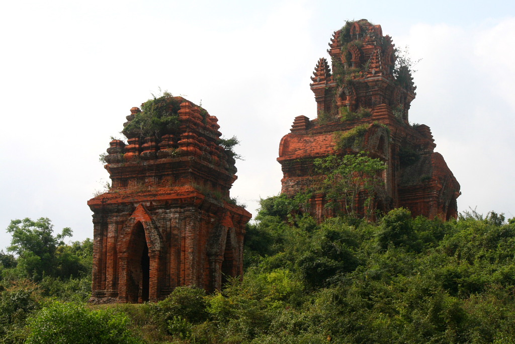
Main article: Champa Banh It Towers, Binh Dinh Province
The historic territory of Champa roughly equals the South Central Coast region, although it has at times extended well into the North Central Coast and its influence also extended into the Central Highlands. Except for its first capital, all of Champa's political centers were located in the South Central Coast. Some of the earlier capitals, as well as the religious center of Mỹ Sơn and the port city of Hội An were located in the territory of present-day Quảng Nam Province. Probably due to defeats in wars against Đại Việt the political center shifted further south to Vijaya in what is now Binh Dinh Province. After the fall of Vijaya to Vietnam in 1471, Champa had to retreat to the southern principality of Panduranga (now at Phan Rang in Ninh Thuận Province), while much of occupied Champa continued to exist as a sort of protectorate within Vietnam for some time.[4]:119 Relations with the mountainous hinterland and traders from overseas were crucial. Champa's trade specialized on procuring luxury goods such as eaglewood from the Central Highlands and even as far as Attapeu in southern Laos and selling them to foreign merchants through their ports at Hoi An and Thi Nai.[4]:110-111, 114
Geography
Topography
In contrast to most other coastal regions in Vietnam, the South Central Coast's terrain is not mainly flat. It have a diverse topography with mountain ranges and hills extending not only along the entire border with the Central Highlands but also to the coast,[5] forming several passes, bays, peninsulas, and beautiful sceneries with beaches and mountain backdrops. Many of the highest mountains are at or near the border with the Central Highlands, the highest of which is Ngoc Linh mountain at 2598 meters.[6] There are several high peaks near the coast of Da Nang (696m on Son Tra Peninsula), Binh Dinh Province (up to 874m), Phu Yen Province (up to 814m), Khanh Hoa Province (up to 978m), and Ninh Thuan Province (up to 1040m).[6] Several mountain passes function as geographic borders between the provinces of the region, with one or two provinces between two major passes. Major passes include the Hai Van Pass on the northern border of the region (Da Nang), Binh De pass (đèo Bình Đê) between Quang Ngai Province and Binh Dinh Province, Cu Mong pass (đèo Cù Mông) between Binh Dinh Province and Phu Yen Province and Ca pass (đèo Cả) between Phu Yen Province and Khanh Hoa Province.[6]
The region includes several islands. Some of the larger ones are the Ly Son Islands, the Cham Islands, and Phu Quy island. The Paracel Islands and the Spratly Islands are officially administered by Da Nang and Khanh Hoa Province. However, sovereignty over them is disputed and Vietnam actually controls only some of the Spratly Islands.
Hydrography
There are several rivers along the South Central Coast, the most significant being Thu Bon River in Quang Nam Province and Da Rang River in Phu Yen Province (most of the latter's river system is in the Central Highlands.[5] Other major rivers include Tra Khuc River in Quang Ngai Province, Côn River in Binh Dinh Province, Ki Lo River in Phu Yen Province, Cái River in Khanh Hoa Province, and Dinh River in Ninh Thuan Province.[6]
Climate
Summer temperatures average above 28°C along most of the coast with slightly lower temperatures further inland. Winters are significantly cooler with average temperatures ranging from around 20 to 25°C.[5] Interestingly, the region includes some of the most arid (Ninh Thuan Province and Binh Thuan Province) as well as some of wettest climates in Vietnam (Da Nang, parts of Quang Nam Province, Quang Ngai Province), with the rest being somewhere in between. While average precipitation per year exceeds 2800mm in many parts of the three provinces in the north of the region, it is less than 800mm in much of Ninh Thuan Province.[5]
Economy
Agriculture, Forestry, Fishing
 Farmer in Binh Dinh Province
 Farmers in Quang Ngai Province
in bn VND (2007)[1] % of national Sector 1 GDP 22,557 9.7 Agriculture gross output 23,949.1 10.1 Forestry gross output 1325.1 12.35 Fishery gross output 12,410.8 14.21 The South Central Coast's sector 1 (agriculture, forestry, fishing) performance can be seen as average in the national context, with its GDP contribution similar to its population share (9.7% and 9.5%). Rice output is below average, but output of some other crops (see table below) as well as forestry and fishing are above average.
The province with the largest sector 1 economy is Binh Dinh (contributing 22.9% to the regions sector 1 GDP), due to its relatively large output in agriculture, forestry, and fishing. It is followed by Quang Nam Province with 15%, Binh Thuan Province with 14.6%, Quang Ngai Province and Khanh Hoa Province with around 13% each.[2] Forestry output is concentrated in Quang Nam Province and Binh Dinh Province with around 25% each, with Quang Ngai Province and Binh Thuan Province contribute another 15% each, while Da Nang and especially Ninh Thuan Province have very small forestry sectors.[2] Fishing output is highest in Khanh Hoa Province (22.3%) and Binh Dinh Province (19.6%), followed by Phu Yen Province and Quang Ngai Province with around 12% each and Quang Nam Province, Binh Thuan Province and Ninh Thuan Province with 9 to 10% each.[2]
2.52 million tons of rice were harvested in the South Central Coast in 2007, 7% of Vietnam's total rice harvest.[2] The main producers are Binh Dinh (580kt in 2007), Binh Thuan (434kt), Quang Nam (395kt), Quang Ngai (381kt), and Phu Yen (321kt).[1] The region's maize harvest made up 7.5% of the nation's total.[2]
Output (2007)[1] % of national Major producers Cotton 3000 tons 18.63 Binh Thuan (2kt, 12.4%), Phu Yen (800t, 5%), Ninh Thuan (200t, 1.2%) Tobacco 5000 tons 15.67 Ninh Thuan (3.3kt, 10.3%), Quang Nam (900t, 2.8%), Phu Yen (700t, 2.2%) Sugar-cane 2,643,600 tons 15.21 Phu Yen (1mt, 6%), Khanh Hoa (738kt, 4.25%), Quang Ngai (390kt, 2.25) Coconuts 126,696 tons 12.1 Binh Dinh (95kt, 9%), Quang Ngai (13.7kt, 1.3%) Cashew nuts 33,391 tons 11.06 Binh Thuan (17.5kt, 5,8%), Khanh Hoa (5.2kt, 1.74%), Binh Dinh (4.2kt, 1.4%) Peanuts 51,900 tons 10.28 Quang Nam (16.9kt, 3.35%), Binh Dinh (13.7kt, 2,71%), Quang Ngai (11.1kt, 2.2%), Binh Thuan (6.8kt, 1.35%) Pepper 3445 tons 3.82 Binh Thuan (2.3kt, 2.6%) Rubber 12,996 tons 2.16 Binh Thuan (12.3kt, 2%) Some tea and coffee are also planted in the region, but their output is not significant in the national context.
Industry
The South Central Coast is central Vietnam's most industrialized region, mostly due to major industrial centers such as Da Nang and Khanh Hoa Province. However, industrialization in the region is still lagging behind the national average and is far behind Vietnam's two major industrial hubs around Ho Chi Minh City and Hanoi. The region's industrial GDP was 35,885.4 billion VND in 2007, accounting for 37.35% of the region's total GDP and 7.54% of Vietnam's industrial GDP.[2] More than 40% of that is produced in Khanh Hoa Province and Da Nang (21.8% and 20%) and another 13 to 14% each by Quang Nam Province and Binh Dinh Province. Binh Thuan Province has been able to increase its share to 12% with growth rates in industry averaging 21.6% from 2000 to 2007. Most other provinces have achieved growth between 15 and 20%, with slower growth only in the established industrial centers of Da Nang (14.8%) and Khanh Hoa Province (13%).[2] The regions average industrial growth rate was 16.3% per year from 2000 to 2007, making the main driving force of the economy.[2]
 Rural brick factory in Quang Ngai Province
Da Nang has a relatively diversified industrial sector including textiles, fabric, fertilizer, cement, soap, paper, pharmaceuticals etc.[1] Khanh Hoa's industrial sector is still more reliant on basic industries such as food and seafood processing and beverages. The province also benefited significantly from investment related to the former Russian naval base at Cam Ranh, to which around 30 factories were attached.[7] Quy Nhon is the region's third largest industrial center.[5] It has been able to capitalize on its advantage as a gateway to the Central Highlands to develop resource-based industries (wood processing and stone processing) and a major furniture manufacturing cluster. Other industries are more dispersed, such as construction materials and basic food processing.
New industrial centers are currently being developed in the economic zones: Chu Lai Economic Zone in southern Quang Nam Province, nearby Dung Quat Economic Zone (with Dung Quat refinery) in northern Quang Ngai Province, Nhon Hoi Economic Zone in Quy Nhon, and Van Phong Economic Zone in northern Khanh Hoa Province. All four zones have large areas of land, major infrastructure and industrial projects. However, in contrast to the smaller industrial parks, they are not limited to industrial sectors.
Infrastructure
Transport
 1A in Binh Dinh
Vietnam's main north-south transport corridors run through the whole South Central Coast region. The North-South Railway runs along the region, with Reunification Express stops at Da Nang Railway Station, Dieu Tri Railway Station, and Nha Trang Railway Station. Stations with less frequent stops are Tam Ky Railway Station, Quang Ngai Railway Station, Quy Nhon Railway Station, Tuy Hoa Railway Station, Thap Cham Railway Station, Muong Man Railway Station, as well as several local railway stations. The two-lane National Road 1 connects all major cities of the region to the rest of the country (Quy Nhon and Nha Trang by extension 1D and 1C). The Ministry of Transport is planning the construction of a 139.5km four-lane highway from Da Nang to Quang Ngai Province in cooperation with foreign donors.[8]
The region is connected to the Central Highlands by several national roads at Phan Rang (National Road 27 to Da Lat), Ninh Hoa, Khanh Hoa Province (26 to Buon Ma Thuot), Tuy Hoa (25 to Pleiku via Ayun Pa) Quy Nhon (19 to Pleiku), and western Quang Nam Province (14/ Ho Chi Minh Road to Kon Tum).[9]
The largest airport in the region is Da Nang International Airport with flights to various cities in Vietnam, Singapore, Siem Reap, Guangzhou, Shanghai and seasonal flights to other cities in mainland China and Taiwan. The region's second international airport at Cam Ranh (serving Nha Trang has only seasonal international flights. Phu Cat Airport (serving Quy Nhon) and Dong Tac Airport (serving Tuy Hoa) have only domestic flights. Chu Lai in southern Quang Nam Province has an international airport, but only domestic flights.
Da Nang Port and Quy Nhon Port are the region's major ports. Another major port is under construction at Van Phong in Khanh Hoa Province.
Energy
The South Central Coast has limited potential for hydro-power plants and has therefore not been a major part of EVN's mosty hydro-focused strategy. However, it is at the forefront of many of Vietnam's efforts to diversify electricity sources away from hydro-power. The country's first nuclear power plant is under construction in Ninh Thuan Province.[10] A second nuclear power project is being prepared with Japanese partners and will also be in Ninh Thuan.[11] A 200 MW wind power wind power plant is under construction in Ninh Thuan Province and is planned to be completed in 2012.[12] Other wind power plants are being constructed in Binh Thuan Province. Binh Thuan is also the location of a 1200 MW electro-thermal plant currently under construction.[13]
Demography
The South Central Coast region had a population of 8.93 million. The three northern provinces of Quang Nam, Quang Ngai and Binh Dinh have the largest populations and together make up almost half of the region's population (47.7%).[2]
2.82 million or 31.6% of them live in cities and towns. More than half of the region's urban population is in Da Nang, Khanh Hoa Province and Binh Thuan Province, while more than half of the rural population is in the provinces Quang Nam, Binh Dinh and Quang Ngai.[2]
Annual population growth has averaged 1.22% from 2000 to 2007, with Da Nang recording the fastest population growth at 1.95%. Growth in the three northern provinces of Quang Nam, Quang Ngai and Binh Dinh has been slowest at around 1%. The four other provinces had average growth rates between 1.26% (Khanh Hoa Province) and 1.59% (Ninh Thuan Province).[2]
The region's population is ethnically clearly dominated by the Vietnamese people (Kinh). There are some minorities, the most significant of which are the Cham, the descendants of Champa. They live mostly in the lowlands around Phan Rang and northern Binh Thuan Province, with smaller communities in other provinces such as southern Binh Dinh. Other minorities live mostly in the mountainous western parts of the region. Areas inhabited by minority people make up more than half of Quang Nam Province and Quang Ngai Province.[5]
References
- ^ a b c d e General Statistics Office (2009): Socio-economical Statistical Data of 63 Provinces and Cities. Statistical Publishing House, Hanoi
- ^ a b c d e f g h i j k l calculations based on General Statistics Office (2009): Socio-economical Statistical Data of 63 Provinces and Cities. Statistical Publishing House, Hanoi
- ^ Taylor, Keith Weller (1983): The Birth of Vietnam. University of California Press. pp. 89, 107, 111, 117
- ^ a b Hardy, Andrew (2009): Eaglewood and the Economic History of Champa and Central Vietnam. in Hardy, Andrew et al. (ed): Champa and the Archaeology of Mỹ Sơn (Vietnam). NUS Press, Singapore.
- ^ a b c d e f Atlat Dia li Viet Nam (Geographical Atlas of Vietnam). NXB Giao Duc, Hanoi: 2010
- ^ a b c d Viet Nam Administrative Atlas. Cartographic Publishing House, Hanoi 2010
- ^ "Nga xây lại quân cảng Cam Ranh?". BBC Vietnamese. 2010-10-07. http://www.bbc.co.uk/vietnamese/vietnam/2010/10/101007_russia_camranh.shtml. Retrieved 2011-07-08.
- ^ "Contstruction of Da Nang-Dung Quat high-speed road". Thoi Bao Kinh Te Viet Nam. 2010-10-12. http://www.intellasia.net/news/articles/infra_resources/111305985.shtml. Retrieved 2011-07-08.
- ^ Vietnam Road Atlas (Tập Bản đồ Giao thông Đường bộ Việt Nam). Cartographic Publishing House (Vietnam), 2004
- ^ "Vietnam stays the nuclear course". Asia Times. 2011-05-14. http://www.intellasia.net/news/articles/business/111324463.shtml. Retrieved 2011-07-08.
- ^ "Gov’t: Nuclear power project to move ahead". The Saigon Times. 2011-03-30. http://english.thesaigontimes.vn/Home/society/nation/16018/. Retrieved 2011-07-08.
- ^ "Construction on wind power plant begins". Thoi Bao Kinh Te. 2010-12-23. http://www.intellasia.net/news/articles/infra_resources/111312042.shtml. Retrieved 2011-07-08.
- ^ "TQ cho VN vay 300 triệu USD xây nhiệt điện". BBC Vietnamese. 2010-12-18. http://www.bbc.co.uk/vietnamese/vietnam/2010/12/101218_china_vn_loan.shtml. Retrieved 2011-07-08.
Subdivisions of Vietnam Regions Municipalities Can Tho · Da Nang · Hai Phong · Hanoi · Ho Chi Minh City
Provinces An Giang · Bac Giang · Bac Kan · Bac Lieu · Bac Ninh · Ba Ria-Vung Tau · Ben Tre · Binh Dinh · Binh Duong · Binh Phuoc · Binh Thuan · Ca Mau · Cao Bang · Dak Lak · Dak Nong · Dien Bien · Dong Nai · Dong Thap · Gia Lai · Ha Giang · Ha Nam · Ha Tinh · Hai Duong · Hoa Binh · Hau Giang · Hung Yen · Khanh Hoa · Kien Giang · Kon Tum · Lai Chau · Lam Dong · Lang Son · Lao Cai · Long An · Nam Dinh · Nghe An · Ninh Binh · Ninh Thuan · Phu Tho · Phu Yen · Quang Binh · Quang Nam · Quang Ngai · Quang Ninh · Quang Tri · Soc Trang · Son La · Tay Ninh · Thai Binh · Thai Nguyen · Thanh Hoa · Thua Thien-Huế · Tien Giang · Tra Vinh · Tuyen Quang · Vinh Long · Vinh Phuc · Yen Bai
List of Districts · List of district-level subdivisions in Vietnam
Categories:- Nam Trung Bộ Region
- Regions of Vietnam
- Geography of Vietnam


Wikimedia Foundation. 2010.