- Mwdwl-eithin
-
Mwdl-eithin 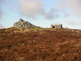
Mwdwl-eithin peak with cairn on left and trig point obscured by ruined buildingElevation 532 m (1,745 ft) Prominence 265 m (869 ft) Parent peak Carnedd y Filiast Listing Marilyn Location Location Conwy,  Wales
WalesRange Snowdonia Coordinates 53°04′22″N 3°37′04″W / 53.0727°N 3.6178°WCoordinates: 53°04′22″N 3°37′04″W / 53.0727°N 3.6178°W Topo map OS Landranger 115 OS grid SH917540 Mwdwl-eithin is a gently rising mountain about 10 miles (16 km) east of Betws-y-Coed lying on the Denbigh Moors (Mynydd Hiraethog in Welsh) of North Wales (the highest point) reaching a height of 532 metres (1,745 ft). On its summit is a trig point and a ruined building which still provides shelter against a storm. A few metres away is a large raised stone cairn.
The whole area is underlain by Silurian mudstone which was extensively glaciated during the last British glaciation. The whole area is now very wet moorland dominated by heather (Calluna and Erica spp.) and rushes. Three of the surrounding valleys and depressions have been used for drinking water storage reservoirs, Llyn Alwen, Llyn Aled and Alwen Reservoir.
Categories:- Marilyns of Wales
- Mountains and hills of north Wales
- Clwyd geography stubs

Wikimedia Foundation. 2010.