- De Kooy Airfield
-
De Kooy Airfield
Vliegveld De Kooy
Den Helder Airport
Maritiem Vliegkamp De Kooy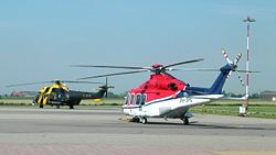
IATA: DHR – ICAO: EHKD Summary Airport type Military/Public Operator Royal Netherlands Navy / Den Helder Airport CV Location Den Helder, Netherlands Elevation AMSL 4 ft / 1 m Coordinates 52°55′25″N 004°46′50″E / 52.92361°N 4.78056°E Website Runways Direction Length Surface m ft 04/22 1,275 4,183 Concrete Sources: Airport website[1], AIP[2] De Kooy Airfield (Dutch: Vliegveld De Kooy) (IATA: DHR, ICAO: EHKD) is an airfield 2.9 NM (5.4 km; 3.3 mi) south[2] of Den Helder, the Netherlands, named after the nearby hamlet De Kooy. It serves as both a civilian airport under the name Den Helder Airport and a naval airport under the name Maritiem Vliegkamp De Kooy (Dutch for Maritime Aviation Site De Kooy).
Most movements on the De Kooy are made by helicopters, bringing workers to and from offshore oilrigs and naval helicopters such as the Westland Lynx of the Royal Netherlands Navy. But fixed-wing aircraft visit and operate from the airport as well. Skyline Aviation operates from De Kooy, who mainly operate business aircraft but also do airwork such as aerial photography for both civilian and military contractors. Amongst their fleet of aircraft most noticeable are several Aero L-39 Albatros jets.
Contents
Future
The oil fields in the North Sea will eventually be depleted and when that happens the airport would lose most of its helicopter movements and thus alternative markets are being looked at, such as business and holiday flights. At the moment there are no scheduled flights from De Kooy. The navy may move its helicopter operations from De Kooy to Gilze-Rijen Air Base.
See also
References
- ^ Den Helder Airport, official site
- ^ a b EHKD – DEN HELDER/De Kooy. AIP from AIS the Netherlands, effective 20 October 2011
External links
- Skyline Aviation
- Photos taken at Den Helder - De Kooy (DHR / EHKD) from Airliners.net
- Current weather for EHKD at NOAA/NWS
- Accident history for DHR at Aviation Safety Network
 Netherlands airports
Civilian, controlled Amsterdam Airport Schiphol · Enschede Airport Twente · Groningen Airport Eelde · Maastricht Aachen Airport · Rotterdam The Hague AirportMilitary airports Deelen Air Base · De Kooy Airfield · De Peel Air Base · Eindhoven Airport · Gilze-Rijen Air Base · Leeuwarden Air Base · Volkel Air Base · Woensdrecht Air BaseUncontrolled airports Heliports Glider and ultra-light Middenmeer Aerodrome · Oostwold Airport · Stadskanaal Airfield · Terlet Airfield · TrafficPort VenloFormer Categories:- Airports in the Netherlands
- Buildings and structures in North Holland
- Den Helder
- Royal Netherlands Air Force bases

Wikimedia Foundation. 2010.