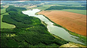
- Nőtincs
-
Nőtincs Country  Hungary
County Nógrád Area – Total 20.47 km2 (7.9 sq mi) Population (2001) – Total 1,213 – Density 59/km2 (152.8/sq mi) Time zone CET (UTC+1) – Summer (DST) CEST (UTC+2) Postal code 2610 Area code(s) 35 Nőtincs (Slovak: Netejč, German: Nititsch), a pictorial locality looking back on a thousand-year old history is in Nógrád county, Hungary.The village is located 51 km (32 mi) north of Budapest near the European route E77, halfway between Vác and Balassagyarmat. Nőtincs is seated at the border of Cserhát and Börzsöny hills. Its location determines the function of the village.
Contents
Demographic data
1213 inhabitants. Of it is 96.3% Hungary; 0.6% gypsy (and/or Sinti and Roma); 0.4% Germans; 0.4% Slovaks as well as 3.6% without closer data. In the village are 466 housing units.
Religion
Roman-catholic: 83.1% Greek-catholic: 0.5% Reformed: 2.8% Lutheraner: 3.6% Other faith associatednesses: 0.4% Denomination lot: 3.1% No indication: 6.4%.
The village was first mentioned in 1317. Its name comes from Nő(Woman)+tincs(tuft). The village of 1,213 (2001) inhabitants is situated 52 km (32 mi) from Budapest (the capital of Hungary), in the south-west of county Nógrád, at the foot of Naszály-hill and near Börzsöny-mountains, in the valley of Brooks Lókos and Hangya in a territory of 2,048 ha.
It was first mentioned in records in 1317. Its Roman Catholic Church was built in 1415. The Gyurcsányi-Scitovszky mansion was built in 1809 in a 4 ha primeval park in the middle of the village. The statue of St. Florian on the facade of the old Catholic school was made around 1780.
Sights in neighbourhood
- Bánk: Lake (beach, fishing place, water-stage), every summer nationality festival
- Rétság: St. Andrew Roman Catholic church, Kovács mansion
- Diósjenő: Lake (fishing place), open-air bath
- Felsőpetény: Church, Almássy-manson
- Nógrád: Spectacular ruins of castle Nógrád, which was the centre of Nógrád county between 11th and 13th centuries and gave the name to the county
External links
- Official website in Hungarian
Categories:- Populated places in Nógrád county
- Slovak communities in Hungary
- Hungarian German communities
Wikimedia Foundation. 2010.


