- Clairemont, San Diego
-
Not to be confused with Claremont, California, the incorporated city in eastern Los Angeles County.
Clairemont — Community of San Diego — Location within Northwestern San Diego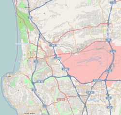
 Clairemont
Coordinates: 32°49′14″N 117°11′24″W / 32.820461°N 117.190133°W Country United States State California County County of San Diego City City of San Diego Clairemont is a suburban neighborhood in northern San Diego.
It includes the separate neighborhoods of North Clairemont, South Clairemont, Clairemont Mesa East and Clairemont Mesa West. It is bordered by State Route 52 in the north, Interstate 805 in the east, Interstate 5 in the west, and the neighborhood of Linda Vista on the south.
The neighborhood was first developed in the post-war building boom of the 1950s.[1]
Contents
Etymology
Developers Lou Burgener and Carlos Tavares called their community Clairemont after Tavares' wife, Marjorie Claire.[2]
History
 Clairemont Development in the 1950s (Courtesy of San Diego Historical Society)
In 1950, Carlos Tavares and Lou Burgener developed what became San Diego's largest post-war subdivision. Originally dubbed, "The Village Within a City",[3] people started living in Clairemont in May, 1951.[4]
Clairemont's design represented a new concept in community living because it did not incorporate the traditional grid system of uniform blocks and streets. Instead, winding streets and scenic view lots took advantage of the canyons and bluffs overlooking Mission Bay. The first homes, built by Burgener and Tavares Construction Company, had highly customized floor plans.
The developers assembled the necessary acreage to develop Clairemont from three primary land holdings: the Peavey Cattle Ranch, Mission Bay Heights (owned by the Hazard Family), & Tecolote Heights (owned by Jack & Dan Danciger).[3]
Before any homes were built in the new development, Tavares & Burgener invested $125,000 in off-street improvements including sewers, water, and access roads; this was necessary because the proposed development was not adjacent to any developed areas.[3] The original Subdivision map that used the name “Clairemont” for the first time was approved and recorded by the County of San Diego on October 16, 1950. The map was named “Clairemont Unit #1, Map #2725”. This is the area in Clairemont that includes Deerpark Dr., Burgener Blvd., and Grandview St. from Field St. to Jellett St. According to Burgener, "Between 1952 & 1954, seven homes were constructed a day".[3] It is also noted that Clairemont was the largest development of its kind in the country.[3]
Due to the road structure, Clairemont was laid out in a Northern direction from which "North Clairemont" evolved. However, Clairemont began to grow in an eastern direction which is now the political distinction of the area. Clairemont's western side has a majority of family homes created by Pardee homes. There are several apartments in this area but not nearly as many in the eastern side. The eastern side has rows of apartments and duplexes scattered around the area east of Genesee Avenue.[citation needed]
Local architects, Harold Abrams, Benson Eschenbach and Richard George Wheeler, designed 20 floor plans for the first development of 500 homes. Built in South Clairemont, these deluxe houses ranged in price from $13,000 to $20,000, featured spacious floorplans, large view windows, fireplaces, tiled bathrooms, paneling and the then latest kitchen built-ins. After the WWII years of housing shortages, these homes sold quickly. Many of these homes now have updated more open floor plans and 2nd story additions as owners have remodeled the older designs. Many homes have upgraded backyards and patios which take advantage of the ocean breezes which come from nearby Mission Bay. Since much of Clairemont has no Homeowners Associations to enforce code in residential areas, residents often park RV's or boats on the side of the property.[citation needed]
Within a few years, several thousand houses had been constructed, including single family homes, duplexes and apartments. Since Clairemont was somewhat removed from the city proper, commercial business and retail shopping, schools, libraries and other city amenities were designed into the overall plan. Although the concept of suburban living is commonplace today, this approach was considered novel and Tavares' vision for Clairemont had far-reaching implications for San Diego as it stretched the city limits outward and began the now familiar pattern of migration from city to suburb.[5]
Today, the only land that remains vacant in Clairemont (once a vacant prairie) is San Clemente Canyon & Tecolote Canyon.[3] Local residents rallied to save both canyons from development and were designated parks in the 1970s.
A small airport runway (Clairemont Drive) existed from Iroquois Street to just past Dakota Drive in the early aerial photos seen of the area.[citation needed] Aeronautical charts of 1948 and 1951 show it was named San Diego Airpark with an unpaved runway length of 2,900 feet (880 m). Baker Street was the only access from Old Highway 101 (Morena Boulevard) up to the new subdivisions. The 1950s and early 1960s added many new shopping centers and access roads to crisscross the area. Many of the original shopping centers have been redeveloped.
Geography
Tecolote Canyon Golf Course is in the bottom of the southern canyon area. There are streams and trails that extend into finger canyons in the area.
Notable residents
- Kendra Wilkinson, model and television personality
- Adam Gnade, novelist
- Phil Konstantin, television personality, author[citation needed]
Education
- Marston Jr. High[citation needed]
- James Madison High School
- Clairemont High School
- Islamic School of San Diego[6]
- Health Sciences High and Middle College School[7]
- Lindbergh/Schweitzer Elementary School[8]
- The Child's Primary School[9]
- Maria Montessori Schools[10]
- CPMA Middle School[citation needed]
- Innovation Middle School[11]
- San Diego Mesa College
References
- ^ San Diego Source > Locales
- ^ Clairemont Community News, August 2008
- ^ a b c d e f Brown, Christine (November 2, 1977). "Lou Burgener's Story: Clairemont's future hung on a coin flip". The Sentinel. Third article in a series.
- ^ Stone, Joe (December 8, 1969, morning ed). "Climate, View Bless Clairemont". San Diego Union-Tribune.
- ^ Journal of San Diego History
- ^ Islamic School of San Diego
- ^ Health Sciences High and Middle College School
- ^ Lindbergh/Schweitzer Elementary School
- ^ The Child's Primary School K-8
- ^ Maria Montessori School K-8
- ^ Innovation Middle School
External links
Neighborhoods of San Diego Northern Bay Ho · Bay Park · Carmel Valley · Clairemont · Del Mar Heights · Del Mar Mesa · La Jolla · La Jolla Village · Mission Beach · North City · Pacific Beach · Pacific Highlands Ranch · Torrey Hills · Torrey Pines · University City · Village of La JollaNortheastern Black Mountain Ranch · Carmel Mountain Ranch · Mira Mesa · Miramar · Rancho Bernardo · Rancho Encantada · Rancho Peñasquitos · Sabre Springs · San Pasqual Valley · Scripps Ranch · Sorrento Valley · Sorrento Mesa · Torrey HighlandsEastern Birdland · Kearny Mesa · Mission Valley East · Navajo (Allied Gardens · Del Cerro · Grantville · San Carlos) · Serra Mesa · TierrasantaWestern Burlingame · Hillcrest · Linda Vista · Midtown · Mission Hills · Mission Valley West · Morena · North Park · Ocean Beach · Old Town · Point Loma (La Playa · Liberty Station · Loma Portal · Midway · Point Loma Heights · Roseville-Fleetridge · Sunset Cliffs · Wooded Area) · University HeightsCentral Downtown (Columbia · Core · Cortez Hill · East Village · Gaslamp Quarter · Harborview · Little Italy · Marina) · Balboa Park · Bankers Hill · Barrio Logan · Golden Hill · Grant Hill · Logan Heights · Middletown · Sherman Heights · South Park · StocktonMid-City Adams North · Azalea/Hollywood Park · Castle · Cherokee Point · Chollas Creek · City Heights · Colina del Sol · College Area · Corridor · Darnall · El Cerrito · Fairmont Park · Fox Canyon · Gateway · Islenair · Kensington · Normal Heights · Oak Park · Ridgeview · Redwood Village · Rolando · Swan Canyon · Talmadge · Teralta · WebsterSoutheastern Alta Vista · Bay Terraces · Broadway Heights · Chollas View · Emerald Hills · Encanto · Jamacha-Lomita · Lincoln Park · Mountain View · Mount Hope · Paradise Hills · Shelltown · Skyline · Southcrest · Valencia ParkSouthern Border · Egger Highlands · Nestor · Ocean View Hills · Otay Mesa · Otay Mesa West · Palm City · San Ysidro · Tijuana River ValleyCoordinates: 32°49′13.66″N 117°11′24.48″W / 32.8204611°N 117.1901333°W
Categories:- Neighborhoods in San Diego, California


Wikimedia Foundation. 2010.