- St Mary's Church, Lambourn Woodlands
-
St Mary's Church, Lambourn Woodlands 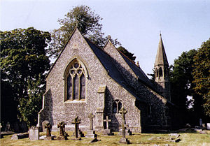
St Mary's Church, Lambourn Woodlands, from the northeatLocation in Berkshire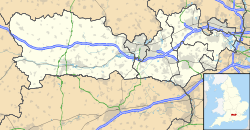
 St Mary's Church, Lambourn Woodlands
Coordinates: 51°28′23″N 1°31′15″W / 51.4731°N 1.5207°W OS grid reference SU 334 749 Location Lambourn Woodlands, Berkshire Country England Denomination Anglican Website Churches Conservation Trust Architecture Functional status Redundant Heritage designation Grade II Designated 11 June 1983 Architect(s) Thomas Talbot Bury Architectural type Church Style Gothic Revival Completed 1852 Specifications Materials Flint with stone dressings
Slate roofsSt Mary's Church, Lambourn Woodlands, is a redundant Anglican church in the village of Lambourn Woodlands, Berkshire, England. It has been designated by English Heritage as a Grade II listed building,[1] and is under the care of the Churches Conservation Trust.[2] The church stands on the south side of the B4000 road, some 2 miles (3 km) south of Lambourn.[2][3]
Contents
History
The church was built in 1852 and designed by the architect Thomas Talbot Bury, a pupil of Augustus Charles Pugin, in Gothic Revival style.[2] It was declared redundant on 1 June 1990, and was vested in the Churches Conservation Trust on 24 July 1991.[4]
Architecture
St Mary's is constructed in flint with stone dressings, and has slate roofs. Its plan is simple, consisting of a three-bay nave, a north aisle and a chancel. To the north of the west end is an octagonal spire. There are three two-light windows in Decorated style, and a three-light east window.[1]
Inside the church is a three-bay arcade carried on octagonal piers. The chancel contains a sedilia and a piscina.[1] The reredos was carved by John Bacon, whose son was the first parish priest.[2]
See also
- List of churches preserved by the Churches Conservation Trust in South East England
References
- ^ a b c "Church of St Mary, Lambourne", The National Heritage List for England (English Heritage), 2011, http://list.english-heritage.org.uk/resultsingle.aspx?uid=1136089, retrieved 12 May 2011
- ^ a b c d St Mary's Church, Lambourn Woodlands, Berkshire, Churches Conservation Trust, http://www.visitchurches.org.uk/Ourchurches/Completelistofchurches/St-Marys-Church-Lambourn-Woodlands-Berkshire/, retrieved 12 May 2011
- ^ Lambourn Woodlands, Streetmap, http://streetmap.co.uk/grid/433286_175067_120, retrieved 12 May 2011
- ^ (PDF) Diocese of Oxford: All Schemes, Church Commissioners/Statistics, Church of England, 2011, p. 9, http://www.churchofengland.org/media/810796/oxford%20-%20all%20schemes.pdf, retrieved 12 May 2011
External links
Categories:- Grade II listed buildings in Berkshire
- Grade II listed churches
- Church of England churches in Berkshire
- Religious buildings completed in 1852
- Gothic Revival architecture in Berkshire
- Churches preserved by the Churches Conservation Trust
- West Berkshire


Wikimedia Foundation. 2010.