- Mountainair, New Mexico
-
Mountainair, New Mexico — Town — Mural in downtown Mountainair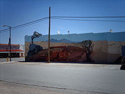 Location of Mountainair, New Mexico
Coordinates: 34°31′11″N 106°14′36″W / 34.51972°N 106.24333°WCoordinates: 34°31′11″N 106°14′36″W / 34.51972°N 106.24333°W Country United States State New Mexico County Torrance Area – Total 1.0 sq mi (2.7 km2) – Land 1.0 sq mi (2.7 km2) – Water 0.0 sq mi (0.0 km2) Elevation 6,519 ft (1,987 m) Population (2000) – Total 1,116 – Density 1,064.2/sq mi (410.9/km2) Time zone Mountain (MST) (UTC-7) – Summer (DST) MDT (UTC-6) ZIP code 87036 Area code(s) 505 FIPS code 35-50370 GNIS feature ID 0892293 Website mountainairnm.gov Mountainair is a town in Torrance County, New Mexico, United States. The population was 1,116 at the 2000 census. It is part of the Albuquerque Metropolitan Statistical Area. The main visitor center for Salinas Pueblo Missions National Monument is in town.
Contents
Geography
Mountainair is located at 34°31′11″N 106°14′36″W / 34.51972°N 106.24333°W (34.519726, -106.243218)[1].
According to the United States Census Bureau, the town has a total area of 1.0 square miles (2.7 km²), all of it land.
Demographics
As of the census[2] of 2000, there were 1,116 people, 452 households, and 281 families residing in the town. The population density was 1,064.2 people per square mile (410.4/km²). There were 545 housing units at an average density of 519.7 per square mile (200.4/km²). The racial makeup of the town was 61.20% White, 1.79% African American, 1.61% Native American, 0.27% Asian, 0.09% Pacific Islander, 29.48% from other races, and 5.56% from two or more races. Hispanic or Latino of any race were 53.14% of the population.
There were 452 households out of which 31.6% had children under the age of 18 living with them, 42.3% were married couples living together, 16.2% had a female householder with no husband present, and 37.8% were non-families. 35.2% of all households were made up of individuals and 20.8% had someone living alone who was 65 years of age or older. The average household size was 2.47 and the average family size was 3.22.
In the town the population was spread out with 29.9% under the age of 18, 8.7% from 18 to 24, 20.4% from 25 to 44, 23.4% from 45 to 64, and 17.6% who were 65 years of age or older. The median age was 38 years. For every 100 females there were 87.6 males. For every 100 females age 18 and over, there were 79.8 males.
The median income for a household in the town was $21,146, and the median income for a family was $25,125. Males had a median income of $25,625 versus $21,094 for females. The per capita income for the town was $12,566. About 19.3% of families and 24.7% of the population were below the poverty line, including 40.5% of those under age 18 and 15.7% of those age 65 or over.
Government
The Mayor of Mountainair is currently Chester Riley. Suzan Brazil serves as Mountainair Town Clerk. It is represented by the Mountainair Town Council which includes Mayor Pro-Tem Larry Zamora, Jeremy Lajuenesse, Frank Anaya and Steve Sanchez.
References
- ^ "US Gazetteer files: 2010, 2000, and 1990". United States Census Bureau. 2011-02-12. http://www.census.gov/geo/www/gazetteer/gazette.html. Retrieved 2011-04-23.
- ^ "American FactFinder". United States Census Bureau. http://factfinder.census.gov. Retrieved 2008-01-31.
External links
Municipalities and communities of Torrance County, New Mexico City 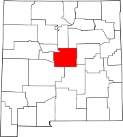
Towns Village CDPs Unincorporated
communitiesCategories:- Populated places in Torrance County, New Mexico
- Towns in New Mexico
- Albuquerque metropolitan area
- Populated places in New Mexico with Hispanic majority populations


Wikimedia Foundation. 2010.