- Dyer, Indiana
-
Town of Dyer, Indiana — Town — 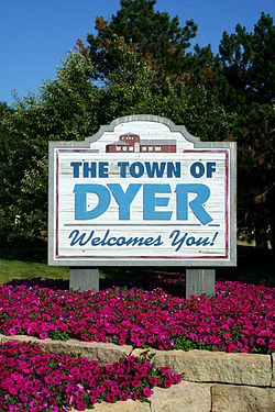
Motto: Striving Higher in Dyer Location in the state of Indiana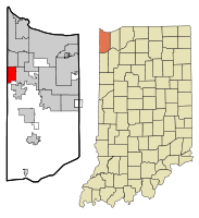
Coordinates: 41°30′1″N 87°30′44″W / 41.50028°N 87.51222°WCoordinates: 41°30′1″N 87°30′44″W / 41.50028°N 87.51222°W Country United States State Indiana County Lake Township St. John Settled[1] 1838 Incorporated 1910 Government - Type Five Member Town Council - Town Council President Debbie Astor (R) - Town Council Vice-President Joe Cinko (D) - Town Council Member Jeff Dekker (R) - Town Council Member Mary Tanis (R) - Town Council Member Connee Trepton (D) Area - Total 6.0 sq mi (15.4 km2) - Land 6.0 sq mi (15.4 km2) - Water 0.0 sq mi (0 km2) Elevation 640 ft (195 m) Population (2010) - Total 16,390 - Density 2,331.2/sq mi (900.1/km2) Time zone CST (UTC-6) - Summer (DST) CDT (UTC-5) ZIP code 46311 Area code(s) 219 FIPS code 18-19270[2] GNIS feature ID 0433824[3] Website http://www.townofdyer.com/ Dyer is a town in St. John Township, Lake County, Indiana, United States. The population was 16,390 at the 2010 census.
This bedroom community lies in the Chicago Metropolitan Area.
Dyer placed 97th on the "100 Best Places to Live in the US" by CNN and Money Magazine in 2005. It was one of two Indiana municipalities to earn this distinction (the other being Fishers outside Indianapolis).[4]
Contents
Geography
Dyer is located at 41°30′01″N 87°30′44″W / 41.500218°N 87.512161°W (41.500218, -87.512161).[5]
Dyer borders Munster to the north, unincorporated St. John Township to the south, Schererville to the east, and Lynwood and Sauk Village in Illinois to the west. The Illinois state line comprises Dyer's entire western border. One of Dyer's neighborhoods, Briar Ridge, spans both Dyer and adjacent Schererville.
According to the United States Census Bureau, the town has a total area of 6.0 square miles (16 km2), all of it land. Dyer is built on mostly flat land with an exception being the steep sand ridge south of US Highway 30. This is the Glenwood Shoreline.
Demographics
Historical populations Census Pop. %± 1930 672 — 1940 976 45.2% 1950 1,556 59.4% 1960 3,993 156.6% 1970 4,906 22.9% 1980 9,555 94.8% 1990 10,923 14.3% 2000 13,895 27.2% 2010 16,390 18.0% Source: [2] As of the census[2] of 2010, there were 16,390 people residing in the town. The population density was 2,731.67 people per square mile (1,064.29.1/km2). There were 6,125 housing units at an average density of 1,020.83 per square mile (397.72/km2). The racial makeup of the town was 90.10% White, 2.50% African American, 0.20% Native American, 2.90% Asian, 0.00% Pacific Islander, 2.40% from other races, and 1.80% from two or more races. Hispanic or Latino of any race were 9.30% of the population.
As of 2009, the median income for a household in the town was $76,599 while the mean income for a household in the town was $93,308. The median income for a family was $87,127 and the mean income for a family was $103,563. The estimated per capita income for the town was $34,275. About 0.7% of families and 1.2% of the population were estimated to be below the poverty line.[6]
History
In 1830, the first permanent settlers came to Northwest Indiana[7]. The earliest records of the documentation of the Dyer, Indiana are dated to 1838. On June 1, 1855 was the original plat for the town[8]. The Town of Dyer was formally incorporated on February 8, 1910[9]. It was divided into three wards in the beginning. The first ward was from all land within the Town of Dyer lying west of Hart Street; the second ward was from all land within the Town of Dyer lying east of Hart Street and south of the Lincoln Highway; and the third ward was from all land within the Town of Dyer north of the Lincoln Highway and east of Hart Street [10]. The founder of Dyer died while digging a trench in the rain, and it collapsed. Hart Street is named for this individual.
Transportation
Roads
Dyer's primary arterial road is U.S. Route 30/Lincoln Highway, which runs east-west through the town. A 1.3-mile (2.1 km) stretch of this route traversing Dyer and Schererville was considered one of the most prominent Seedling Mile projects on the Lincoln Highway when it was constructed in the early 1920s, and came to be known as the highway's "Ideal Section." It remains in use to this day.
Amtrak
Amtrak, the national passenger rail system, provides service to Dyer at the Dyer Amtrak Station. The station is served by the Cardinal with service to Chicago Union Station and New York Penn Station via Washington D.C.'s Union Station. On the days that the Cardinal does not run, the Hoosier State connects Indianapolis to Chicago, where connecting trains take passengers to other destinations in the Amtrak system.[11]
Bus
When Northwest Indiana Regional Bus Authority (RBA) expanded the Hammond Transit System into EasyGo Lake Transit service, one of its new routes included Calumet Avenue in northern Dyer, within walking distance of the Amtrak station. Riders can use this bus route to travel to Munster, Hammond and Chicago's East Side neighborhood, where transfers to other routes provide connections to other Northwest Indiana and Chicago Southland municipalities.
The RBA also operates EasyGo Chicago express bus, which provides rush-hour express service between Dyer and downtown Chicago. The buses travel from Dyer to Chicago in the morning and from Chicago to Dyer in the afternoon. RBA is currently considering adding an additional stop in Merrillville; details pertaining to this extension have not been finalized as of March 2011.
Education
Lake County Public Library operates the Dyer-Schererville Branch at 1001 West Lincoln Highway in adjacent Schererville.[12]
Dyer is served by the Lake Central School Corporation. Three of the system's schools are located within Dyer town limits: Kahler Middle School, on Route 30 west of Hart Street, Protsman Elementary, located north of 213th Street, and Bibich elementary, located just off of 81st street.
Sports
Dyer is home to the Chi-Town Shooters, a minor league professional ice hockey team that is a member of the All American Hockey League. The team's home arena is Midwest Training & Ice Center.
Club Sport League Venue Championships Chi-Town Shooters Ice hockey All American Hockey League Midwest Training & Ice Center Arena 1 (2009) Notable places
Meyer's Castle, built for herbologist Joseph E. Meyer in 1927-1931, is located in the town.
References
- ^ Town of Dyer history page
- ^ a b c "American FactFinder". United States Census Bureau. http://factfinder.census.gov. Retrieved 2008-01-31.
- ^ "US Board on Geographic Names". United States Geological Survey. 2007-10-25. http://geonames.usgs.gov. Retrieved 2008-01-31.
- ^ "Best Places to Live 2005: Dyer, IN snapshot". Money Magazine. 2005. http://money.cnn.com/magazines/moneymag/bplive/2005/snapshots/26407.html. Retrieved May 1, 2010.
- ^ "US Gazetteer files: 2010, 2000, and 1990". United States Census Bureau. 2011-02-12. http://www.census.gov/geo/www/gazetteer/gazette.html. Retrieved 2011-04-23.
- ^ http://www.factfinder.census.gov/servlet/ADPTable?_bm=y&-geo_id=16000US1819270&-qr_name=ACS_2009_5YR_G00_DP5YR3&-ds_name=ACS_2009_5YR_G00_&-_lang=en&-_sse=on
- ^ Town of Dyer history page
- ^ Town of Dyer history page
- ^ Town of Dyer history page
- ^ Town of Dyer history page
- ^ "Amtrak - Stations - Dyer, IN (DYE)". Amtrak. http://www.amtrak.com/servlet/ContentServer?pagename=am/am2Station/Station_Page&code=DYE. Retrieved August 5, 2010.
- ^ "Locations and Hours." Lake County Public Library. Retrieved on January 21, 2009.
External links
Municipalities and communities of Lake County, Indiana County seat: Crown Point Cities Crown Point | East Chicago | Gary | Hammond | Hobart | Lake Station | Whiting

Towns Cedar Lake | Dyer | Griffith | Highland | Lowell | Merrillville | Munster | New Chicago | St. John | Schererville | Schneider | Winfield
Townships Calumet | Cedar Creek | Center | Eagle Creek | Hanover | Hobart | North | Ross | St. John | West Creek | Winfield
Unincorporated
communitiesAinsworth | Belshaw | Brunswick | Creston | Deep River | Deer Creek | Dinwiddie | Green Acres | Hawthorne Hills | Klaasville | Kreitzburg | Lake Dalecarlia | Lake Hills | Lakes of the Four Seasons‡ | Leroy | Liberty Park | Liverpool | New Elliott | North Hayden | Orchard Grove | Palmer | Range Line | Rolling Hill Estates | Ross | Shady Lawn | Shelby | Southeast Grove | Southmoor Park | Van Loon | Wald View | Woodmar
Footnotes ‡This populated place also has portions in an adjacent county or counties
Categories:- Populated places in Lake County, Indiana
- Towns in Indiana
- Populated places established in 1838


Wikimedia Foundation. 2010.