- Ernei
-
Ernei
Nagyernye— Commune — 
 Ernei
Ernei
NagyernyeCoordinates: 46°36′0″N 24°39′0″E / 46.6°N 24.65°ECoordinates: 46°36′0″N 24°39′0″E / 46.6°N 24.65°E Country  Romania
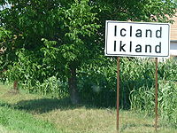
County Mureş County Status Commune Government – Mayor Ferenc Jánosi (Democratic Union of Hungarians in Romania) Population (2002) – Total 5,219 Time zone EET (UTC+2) – Summer (DST) EEST (UTC+3) Ernei (Hungarian: Nagyernye; Hungarian pronunciation: [nɒɟɛrɲɛ]) is a commune in Mureş County, Transylvania, Romania, composed of six villages:
- Căluşeri / Székelykál
- Dumbrăvioara / Sáromberke
- Ernei
- Icland / Ikland
- Săcăreni / Székes
- Sângeru de Pădure / Erdőszengyel
Contents
History

It formed part of the Székely Land region of the historical Transylvania province. Until 1876, it fall within Marosszék, thereafter until 1918, the village belonged to the Maros-Torda County of the Kingdom of Hungary. After the Treaty of Trianon of 1920, it became part of Romania. As a result of the Second Vienna Award, it belonged to Hungary again between 1940 and 1944. After WWII, it came under Romanian administration and became part of Romania in 1947. Between 1952 and 1960, it formed part of the Hungarian Autonomous Province, then, of the Mureş-Hungarian Autonomous Province until it was abolished in 1968. Since then, the commune is part of Mures County.Demographics
The commune has an absolute Székely Hungarian majority. According to the 2002 Census it has a population of 5,219 of which 82.93% or 4,328 are Hungarian. It reached its maximum population in 1966 with 6014 people.
See also
- List of Hungarian exonyms (Mureş County)
External links
- Nagyernye Reformed Church Congregation (Hungarian)
References
Categories:- Communes in Mureș County


Wikimedia Foundation. 2010.