- Euboea
-
For the mythological figure, see Euboea (mythology). For the administrative unit, see Euboea (regional unit).
Euboea
Εύβοια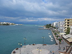
ChalkisGeography 
Coordinates: 38°30′N 24°00′E / 38.5°N 24°E Island chain: Aegean Islands Area: 3,684.848 km² (1,423 sq.mi.) Highest mountain: Mt. Dirphys (1,745 m (5,725 ft)) Government  Greece
Periphery: Central Greece Prefecture: Euboea Capital: Chalcis Statistics Population: 198,130 (as of 2001) Density: 54 /km² (139 /sq.mi.) Postal code: 34x xx Area code: 22x0 License code: XA Website www.naevias.gr Euboea[1] (Greek: Εύβοια, Évia; Ancient Greek: Εὔβοια, Eúboia) is the second largest Greek island in area and population, after Crete. The narrow Euripus Strait separates it from Boeotia in mainland Greece. In general outline it is a long and narrow, seahorse-shaped island; it is about 150 kilometres (93 mi) long, and varies in breadth from 50 kilometres (31 mi) to 6 kilometres (3.7 mi). Its general direction is from northwest to southeast, and it is traversed throughout its length by a mountain range, which forms part of the chain that bounds Thessaly on the east, and is continued south of Euboea in the lofty islands of Andros, Tinos and Mykonos.
Contents
Geography
 Beach at Chiliadou in Euboea.
Like most of the Greek islands, Euboea was originally known under other names in ancient times, such as Macris and Doliche from its shape, Ellopia and Abantis from the tribes inhabiting it.
Euboea was believed to have originally formed part of the mainland, and to have been separated from it by an earthquake. This is fairly probable, because it lies in the neighbourhood of a fault line, and both Thucydides and Strabo write that the northern part of the island had been shaken at different periods. In the neighbourhood of Chalcis, both to the north and the south, the bays are so confined as to make plausible the story of Agamemnon's fleet having been detained there by contrary winds. At Chalcis itself, where the strait is narrowest at only 40 m, it is called the Euripus Strait. The extraordinary changes of tide which take place in this passage have been a subject of note since classical times. At one moment the current runs like a river in one direction, and shortly afterwards with equal velocity in the other. A bridge was first constructed here in the twenty-first year of the Peloponnesian War (410 BC). The name Euripus developed during the Middle Ages into Evripo and Egripo, and in this latter form transferred to the whole island. Later the Venetians, when they occupied the district, altered it to Negroponte, referring to the bridge which connected it with the mainland.
The main mountains include Dirphys (1,745 m), Pyxaria (1,341 m) in the northeast and Ochi (1,394). The neighboring gulfs are the Pagasetic Gulf in the north, Malian Gulf, North Euboean Gulf in the west, the Euboic Sea and the Petalion Gulf. At the 2001 census the island had a population of 198,130, and a total land area of 3,684.848 km².
History
Ancient
The history of the island is for the most part that of its two principal cities, Chalcis and Eretria. Both cities were Ionian settlements from Attica, and their importance in early times is shown by their numerous colonies in Magna Graecia and Sicily, such as Cumae and Rhegium, and on the coast of Macedonia. In this way, they opened new trade routes to the Greeks, and extended the field of western civilization.[2]
The strength of their commerce is shown by the fact that the Euboic scale of weights and measures was used in Athens until Solon, and among the Ionic cities generally. They were rival cities, and appear to have been equally powerful at first; one of the earliest of the sea battles mentioned in Greek history took place between them, and it is also said[who?] that many of the other Greek states took part.[citation needed]
In 490 BC, Eretria was utterly ruined and its inhabitants were transported to Persia. Though it was restored after the Battle of Marathon, on a site at a little distance from its original position, it never regained its former eminence, but it was still the second city on the island. From this time, its neighbour, Chalcis, held an undisputed supremacy. Already, however, this city had suffered from the growing power of Athens. In 506 BC, the Chalcidians were totally defeated by the Athenians, who established 4,000 Attic settlers on their lands, and seem to have reduced the whole island to a condition of dependence.[citation needed]
Again, in 446 BC, when Euboea endeavoured to throw off the yoke, it was once more reduced by Pericles, and a new body of settlers was planted at Histiaea in the north of the island, after the inhabitants of that town had been expelled. The Athenians fully recognized its importance to them, for supplying them with grain (i.e., wheat) and cattle, securing their commerce, and guaranteeing them against piracy, because its proximity to the coast of Attica rendered it extremely dangerous to them when in other hands. However, in 410 BC, the island succeeded in regaining its independence. After this, it took sides with one or other of the leading states, until, after the Battle of Chaeronea, it passed into the hands of Philip II of Macedon, and finally into those of the Romans.
Medieval
See also: Lordship of NegroponteIn 1157 all the coastal towns of Euboea were destroyed by a Sicilian force.[3]
In the Middle Ages, Euboea came into prominence following the Fourth Crusade. In the partition of the Byzantine Empire by the crusaders, the island was occupied by a number of Lombard families, who divided it into three (later six) baronies. The island's rulers came early on under the influence of the Venetian Republic, which secured control of the island's commerce in the War of the Euboeote Succession and gradually expanded its control, until they acquired full sovereignty by 1390.
On 12 July 1470, during the Ottoman–Venetian War of 1463–1479 and after a protracted and bloody siege, the well-fortified city of Negropont (Chalkis) was wrested from Venice by Mehmed II and the whole island fell into the hands of the Ottoman Empire. Although the name Negropont remained current in European languages until the 19th century, the Turks themselves renamed the city and the island Eğriboz or Ağriboz from their word for the Euripus Strait. Under Ottoman rule, Ağriboz was the seat of a sanjak.
At the conclusion of the Greek War of Independence in 1830, the island constituted a part of the newly-established independent Greek kingdom.
Modern
 View from Kandili mountain
Euboea is linked to the mainland by two bridges, one that runs through Chalkis and is also accessible from Thebes, and another which bypasses Chalcis and is accessed from Athens. All of Euboea's modern bridges are suspended.
In the 1980s, the Dystos lake was filled with grass which was set on fire by farmers to make more farmland. This act caused devastation of much of the plants and the environment in that area.[citation needed] A part of the lake later regenerated. Also the municipalities of Anthidona and Avlida in the mid to late 20th century, which once were part of the eastern part of the Boeotia Prefecture, reverted to Chalkis.[citation needed] Since then, the postal codes corresponded with the rest of Euboea, including Skyros.
Recent
On January 24 through January 28, 2006, a snowstorm which also affected Eastern Europe brought heavy snowfalls with snow accumulating to heights ranging from 1 to 4 metres (3.3 to 13 ft), cutting off roads from the rest of Greece in the northern, eastern and southern parts of the island. Electricity was cut off to parts of the island for several days. Two days later when the snowstorm tapered off, villages in the south and north remained cut off from roads and water supply. Communications were later restored as bulldozers cleared away the snow as far as Aliveri a day later. The snowstorm became one of the worst in the island's history.[citation needed] Another system arrived on February 7, 2005 and brought heavy snows that isolated several residents in their homes with 3 to 5 metres (9.8 to 16 ft) of snow, enough to reach upper balconies and almost cover homes in snow over their roofs in several villages.[citation needed] In Kampia, snowfall of up to 2 metres (6.6 ft) covered people's cars, and some people had to dig away the snow to get into their vehicles. Roads were also blocked and some locations were cut off from the rest of the island. The storm did not cause blackouts. A day later, temperatures began to rise and roads were re-opened and communications restored.
Another natural disaster was the forest fire that occurred in the Aliveri part of the island, fires lasted in July 2007 and devastated much of the forests including the vicinity of the hotel and devastated the tourist industry of the island[citation needed]. Fires battled for a few days until the situation ended completely. Hundreds of buildings were damaged.[citation needed].
On October 14, 2008, a tremendous earthquake rumbled the island, measuring 6.6 on the Richter scale. Four months after, the Achaia-Ilia earthquake measured at the same range, mostly the same measurement. The earthquake was even felt in Athens and parts of the mainland[citation needed].
Demographics
The population of the island according to the census of 2001 was 198,130, making it the second most populous island of Greece. As a whole the Euboeans share a cultural identity similar to that of the people in the rest of Central Greece and they speak a southern variety of Greek. In the southern part of the island there are Arvanite communities, with the area south of Aliveri being the northernmost limit of their presence in Euboea. Sarakatsani and Vlachs could be found mainly in the mountainous areas in central and northern Euboea respectively, but nowadays they have abandoned the nomadic way of life and live permanently in the towns and villages across the island.
Economics
The mining areas include magnesite in Mantoudi and Limni, lignite in Aliveri and iron and nickel from Dirfys. Marble is mined 3 km north of Eretria which include Marmor Chalcidicum and asbestos in the northeastern part of Carystus in the Okhi mountain.
The trees include chestnuts.
Transport
- Greek National Road 44, Cen., S, SE
- Greek National Road 77 NW, N, W, Cen.
Local administration
The island belongs to Euboea Prefecture which also includes two municipalities on the mainland, Anthidona and Avlida, as well as the island municipality of Skyros. At the 2001 census the prefecture had a population of 215,136 inhabitants, whereas the island itself had a population of 198,130. The prefecture's land area is 4,167.449 km², whereas the total land area of the municipalities actually on the island is 3,684.848 km², which includes that of numerous small offshore islets (Petalion Islands) near Euboea's southeastern tip.
Wildfires
The 2007 Greek fires were some of the deadliest in world history, killing at least 64 people in the Peloponnese and Evia.
Notable people
- Konstantinos Kallias (9 July 1901- 7 April 2004), politician
- Georgios Papanikolaou (1883–1962) physician, a pioneer in cytology and early cancer detection
- Giannis Skarimpas, writer
- Nikolaos Kriezotis, leader of the Greek Revolution in Euboea
- St. David of Euboea, 16th Century Saint (from the village of Gardinitsa) who built a church dedicated to the Transfiguration
- Elder Porphyrios, Holy Father of the Orthodox Church
- Elder Iakovos, Spiritual Father of St. David's Monastery in Euboea
Sporting teams
- Khalkis-Lilas - Chalkida, third division
- Chalkida BC - Chalkida, Greek A2 League
See also
- List of settlements in the Euboea prefecture
- List of traditional Greek place names
References
- ^ Euboea, Euboia, and Euboaea
 /juːˈbiːə/ are transliterations from the Ancient Greek Εύβοια [éu̯boja], while Evvoia, Evvia, and Eviareflect the Modern Greek pronunciation [ˈevja].
 - ^ Lane Fox, Robin. Travelling Heroes (London: Penguin, 2008) passim
- ^ Norwich, John Julius. Byzantium: The Decline and Fall (New York: Alfred A. Knopf, 1996) p. 116
 This article incorporates text from a publication now in the public domain: Chisholm, Hugh, ed (1911). Encyclopædia Britannica (11th ed.). Cambridge University Press.
External links
Articles on the Aegean Sea GeneralCountries Other Cyclades Amorgos · Anafi · Andros · Antimilos · Antiparos · Delos · Despotiko · Donoussa · Folegandros · Gyaros · Ios · Irakleia · Kardiotissa · Kea · Keros · Kimolos · Koufonisia · Kythnos · Milos · Mykonos · Nata · Naxos · Paros · Polyaigos · Rineia · Santorini · Schoinoussa · Serifopoula · Serifos · Sifnos · Sikinos · Syros · Therasia · Tinos · VousDodecanese Agathonisi · Arkoi · Armathia · Alimia · Astakida · Astypalaia · Çatalada · Chalki · Chamili · Farmakonisi · Gaidaros · Gyali · Imia/Kardak · Kalolimnos · Kalymnos · Kandelioussa · Kara Ada · Karpathos · Kasos · Kinaros · Kos · Küçük Tavşan Adası · Leros · Lipsi · Lebynthos · Nimos · Nisyros · Patmos · Pacheia · Platy · Pserimos · Rhodes · Saria · Salih Ada · Symi · Syrna · Telendos · Tilos · ZaforaNorth Aegean Agios Eustratius · Ammouliani · Ayvalık Islands · Büyük Ada · Chios · Chryse · Cunda · Foça Islands · Fournoi Korseon · Icaria · Imbros · Koukonesi · Lemnos · Lesbos · Metalik Ada · Nissiopi · Oinousses · Psara · Samiopoula · Samos · Samothrace · Tenedos · Thasos · ThymainaSaronic Sporades Adelfoi Islets · Agios Georgios Skopelou · Alonnisos · Argos Skiathou · Dasia · Erinia · Gioura · Grammeza · Kyra Panagia · Lekhoussa · Peristera · Piperi · Psathoura · Repio · Rineia Skyrou · Sarakino · Skandili · Skantzoura · Skiathos · Skopelos · Skyropoula · Skyros · Tsougria · ValaxaCretan Afendis Christos · Agia Varvara · Agioi Apostoloi · Agioi Pandes · Agioi Theodoroi · Agios Nikolaos · Anavatis · Arnaouti · Aspros Volakas · Avgo · Crete · Daskaleia · Dia · Diapori · Dionysades · Elasa · Ftena Trachylia · Glaronisi · Gramvousa · Grandes · Kalydon (Spinalonga) · Karavi · Karga · Katergo · Kavallos · Kefali · Kolokythas · Koursaroi · Kyriamadi · Lazaretta · Leon · Mavros · Mavros Volakas · Megatzedes · Mochlos · Nikolos · Palaiosouda · Peristeri · Peristerovrachoi · Petalida · Petalouda · Pontikaki · Pontikonisi · Praso Kissamou · Prosfora · Pseira · Sideros · Souda · Valenti · Vryonisi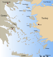
Other Categories:- Euboea
- Islands of Greece
- Aegean islands


Wikimedia Foundation. 2010.