Serra dos Órgãos

Serra dos Órgãos
Serra dos Órgãos National Park
IUCN Category II (National Park)
Dedo de Deus.jpg
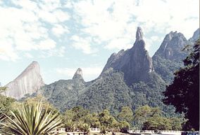
God's Finger Rock: The most famous of all the rock formations in the park.
Location Brazil
Nearest city Teresópolis
Coordinates 22°26′43.26″S 42°59′59.13″W / 22.44535°S 42.9997583°W / -22.44535; -42.9997583Coordinates: 22°26′43.26″S 42°59′59.13″W / 22.44535°S 42.9997583°W / -22.44535; -42.9997583
Area 110 km²
Established 1939

Serra dos Órgãos ("Organs Range", "Range of the Organs") is a mountain range in the state of Rio de Janeiro, Brazil, which was turned into a national park in 1939. It is located about a one-hour drive from the city of Rio de Janeiro.

The Serra dos Órgãos National Park was created in 1939 as the third national park in Brazil. The objective was to protect the native forest on the hillsides and the fresh water springs abundant in the region. When created the park occupied land previously controlled by four municipalities: Petrópolis, Teresópolis, Guapimirim and Magé.

The origin of the unusual name is credited to early Portuguese settlers who thought the ensemble of the hill tops resembled the pipes of organs in European cathedrals.

The Park's area is 110 square kilometres (42 sq mi) and it has 10 peaks higher than 2,000 metres (6,600 ft) and six other peaks over 1,500 metres (4,900 ft) high. The lowest point in the park is located in the relatively flat municipality of Magé, at 145 metres (476 ft). The highest peak is Pedra do Sino (Bell Rock), at 2,263 metres (7,425 ft). The most famous formation in the park is the Dedo de Deus (God's Finger) rock, which resembles a left hand with its index finger stretched, pointing towards the sky. It is 1,692 metres (5,551 ft) high and can be seen in the background of the flag of the Rio de Janeiro state.

The park is part of the larger Serra do Mar chain of mountains, and the most accepted theory about its origin is that it rose about 60 million years ago during earthquakes that caused the Andes to rise. That means it is located in a geologically unstable location, although no incident has ever been recorded in the area.[citation needed]

Temperatures in the mountains can fall as low as 4 °C (39 °F), and the average temperature at 1,000 metres (3,300 ft) is 17 °C (63 °F). Humidity is between 80 and 90% on average, but it can reach 99% at higher altitudes.

The park is one of the few natural habitats of species of Schlumbergera, which were developed into the colourful "Thanksgiving Cactus" and "Christmas Cactus", widely grown as house plants.[1]

References

  1. ^ McMillan, A.J.S.; Horobin, J.F. (1995), Christmas Cacti : The genus Schlumbergera and its hybrids (p/b ed.), Sherbourne, Dorset: David Hunt, ISBN 978-0-9517234-6-3 

Wikimedia Foundation. 2010.

Игры ⚽ Поможем сделать НИР

Look at other dictionaries:

  • Serra dos Órgãos — Die Serra dos Órgãos (Orgelpfeifengebirge, oder Organgebirge ) ist der dritte Nationalpark Brasiliens, und wurde am 30. November 1939 gegründet. Er liegt im Bundesstaat Rio de Janeiro bei Teresópolis, außerdem auf dem Gebiet der Städte Petrópolis …   Deutsch Wikipedia

  • Serra dos Órgãos — 22° 25′ 00″ S 42° 45′ 00″ W / 22.4167, 42.75 …   Wikipédia en Français

  • Serra dos Orgãos Hostel — (Teresópolis,Бразилия) Категория отеля: Адрес: Vale do Garrafão, Teresópoli …   Каталог отелей

  • Serra dos Orgãos — Sẹrra dos Orgãos   [ duz ɔr gãus], Gebirge in Brasilien, im Hinterland von Rio de Janeiro, Teil der Serra do Mar, bis über 2 300 m über dem Meeresspiegel; stark zerklüftete Felsnadeln, Gneis und Granitgipfel; Nationalpark …   Universal-Lexikon

  • Serra — is Latin for a saw [http://www.etymonline.com/index.php?search=sierra searchmode=none] (a view from a high place, and/or a saw, see serrated and sierra), Italian for greenhouse, and Portuguese for mountain range, may mean a number of different… …   Wikipedia

  • Serra do Mar — Dedo de Deus (Finger Gottes) in der Serra dos Órgãos, Rio de Janeiro Die Serra do Mar (portugiesisch: Gebirgszug des Meeres) ist ein 1500 km langer Gebirgszug im Südosten Brasiliens in den Bundesstaaten Espírito Santo, Rio de Janeiro, São Paulo,… …   Deutsch Wikipedia

  • Serra do Mar — Sẹrra do Mar   [ du ; portugiesische »Seegebirge«], Randgebirge des Brasilianischen Berglands in Südostbrasilien, von Santa Catarina bis zum Rio Paraíba, etwa 1 000 km lang, in der Serra dos Orgãos bis 2 263 m über dem Meeresspiegel; steil zur… …   Universal-Lexikon

  • Serra [4] — Serra (in Portugal, Sierra in Spanien), bedeutet eigentlich Säge, daher wegen der zackigen Gipfel Gebirgszug, Gebirge; zu bemerken sind: S. de Abelonira, Theil der S. Morena, s.d. S. de Açor, ein westlich bis gegen Coimbra sich erstreckender… …   Pierer's Universal-Lexikon

  • Chapada dos Veadeiros National Park — Cerrado Protected Areas: Chapada dos Veadeiros and Emas National Parks * UNESCO World Heritage Site …   Wikipedia

  • Chapada dos Guimarães National Park — The Chapada dos Guimarães National Park (Parque Nacional da Chapada dos Guimarães in Portuguese) is a national park in the Brazilian state of Mato Grosso. It is located between 15°10 15º30 S and 55°40 56°00 W. Chapada is a Brazilian word that… …   Wikipedia

Share the article and excerpts

Direct link
Do a right-click on the link above
and select “Copy Link”