- Drees
-
For other uses, see Drees (disambiguation).
Drees 

 DreesLocation of Drees within Vulkaneifel district
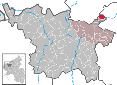
Coordinates 50°20′28″N 6°59′46″E / 50.34111°N 6.99611°ECoordinates: 50°20′28″N 6°59′46″E / 50.34111°N 6.99611°E Administration Country Germany State Rhineland-Palatinate District Vulkaneifel Municipal assoc. Kelberg Mayor Josef Heimer Basic statistics Area 4.11 km2 (1.59 sq mi) Elevation 500 m (1641 ft) Population 154 (31 December 2010)[1] - Density 37 /km2 (97 /sq mi) Other information Time zone CET/CEST (UTC+1/+2) Licence plate DAU Postal code 53520 Area code 02691 Website www.drees-eifel.de Drees is an Ortsgemeinde – a municipality belonging to a Verbandsgemeinde, a kind of collective municipality – in the Vulkaneifel district in Rhineland-Palatinate, Germany. It belongs to the Verbandsgemeinde of Kelberg, whose seat is in the like-named municipality.
Contents
Geography
Location
The municipality lies in the Vulkaneifel, a part of the Eifel known for its volcanic history, geographical and geological features, and even ongoing activity today, including gases that sometimes well up from the earth.
Neighbouring municipalities
Drees borders in the north on Döttingen, in the northeast on Herresbach, Baar and Mittelbaar, in the east on Niederbaar, in the southeast on Nitz, in the south on Kirsbach, in the southwest on Welcherath, in the west on Nürburg and in the northwest on Meuspath.
History
In 1222, Drees had its first documentary mention under the name Dreyse. The word comes from the Celtic term for “bubbling spring”. This is akin to the old Germanic word Thrais, for “bubbles”, “to bubble” or “to swirl”. The namesake mineral spring, the result of volcanic activity in the area, no longer exists.
The village belonged to the Electorate of Cologne until 1794.
Politics
Municipal council
The council is made up of 6 council members, who were elected by majority vote at the municipal election held on 7 June 2009, and the honorary mayor as chairman.
Mayor
Drees’s mayor is Josef Heimer. His deputy is Klaus Brachthäuser[2].
Coat of arms
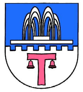
The German blazon reads: Durch Zinnenschnitt geteilt von Blau und Silber. Oben ein silberner Brunnen mit geteiltem Wasserstrahl. Unten ein rotes Antoniuskreuz mit 2 Pilgerglöckchen.
The municipality’s arms might in English heraldic language be described thus: Per fess embattled of seven, azure a fountain with four streams argent, and argent a cross tau, hanging from each arm a bell, gules.
The partition horizontally across the middle in the pattern of a crenellated wall (“Per fess embattled”) refers to the time when Drees belonged to the Electoral-Cologne Amt of Nürburg. The fountain is, in a way, a canting charge, referring to the municipality’s name, which comes from an old Celtic word for a spring (although it hardly resembles the modern German word for this, Brunnen). The “cross tau” – one without an upper arm – is Saint Anthony’s Cross and thus a reference to the municipality’s patron saint, whose attributes include this cross and a bell, two of which also appear in these arms[3].
Culture and sightseeing
Buildings
- Saint Anthony’s and Saint Bernard’s Catholic Church (branch church), Kapellenweg 2, quire from 17th century, biaxial aisleless church, late 18th century.
- At Hauptstraße 5 – timber-frame house, part of an estate complex, partly solid, latter half of 19th century.
- Wayside chapel, southwest of the village on the road to Welcherath, plaster building, possibly 18th century, basalt niche cross marked “16?5” (yeardate therefore uncertain).
- Wayside cross, southeast of the village on the road to Nitz, basalt niche cross from 1646[4].
Economy and infrastructure
Transport
Among the local roads, Kreisstraße (District Road) 93 leads northwards towards Döttingen and to Bundesstraße 258. It also leads westwards by way of Nitz, likewise to the B 258. Southwestwards runs Kreisstraße 92 to Welcherath and Landesstraße (State Road) 94.
Established businesses
North of the village, west of the road to Döttingen, is found an off-road track in a disused quarry run by the company Camp 4 Fun (even in German) where companies and private citizens can drive off-road vehicles over rough ground for training or leisure.
References
- ^ "Bevölkerung der Gemeinden am 31.12.2010" (in German). Statistisches Landesamt Rheinland-Pfalz. 31 December 2010. http://www.statistik.rlp.de/fileadmin/dokumente/berichte/A1033_201022_hj_G.pdf.
- ^ Drees’s council
- ^ Description and explanation of Drees’s arms
- ^ Directory of Cultural Monuments in Vulkaneifel district
External links
- Municipality’s official webpage (German)
- Drees in the collective municipality’s Web pages (German)
- Brief portrait of Drees with film at SWR Fernsehen (German)
- This article incorporates information from the German Wikipedia.
Categories:- Municipalities in Rhineland-Palatinate
- Vulkaneifel geography stubs


Wikimedia Foundation. 2010.