- Bulawayo
-
Bulawayo
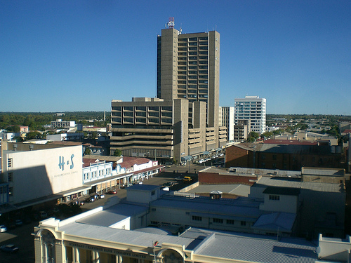
koBulawayo— City — View of Bulawayo's Central Business District from Pioneer House by Prince Phumulani Nyoni

Flag
Coat of armsNickname(s): 'City of Kings', 'Skies', 'Bluez' or 'Bulliesberg' Motto: Si Ye Phambili Location in the Bulawayo Province Location in the Bulawayo Province
 Bulawayo
Coordinates: 20°10′12″S 28°34′48″E / 20.17°S 28.58°ECoordinates: 20°10′12″S 28°34′48″E / 20.17°S 28.58°E Country Zimbabwe Province Bulawayo District City of Bulawayo Settled 1840 Incorporated (town) 1897 Incorporated (city) 1943 Divisions
4 Districts,29 Wards,156 Suburbs Government – Type Provincial Municipality – Mayor Thaba Moyo Area – Water 129.3 km2 (49.9 sq mi) – Urban 650.5 km2 (251.2 sq mi) – Metro 899.459 km2 (347.3 sq mi) Elevation[1] 1,370 m (4,495 ft) Population (2010) – City 2,000,000 – Density 2,222/km2 (5,755/sq mi) – Urban 1,500,000 – Urban density 2,305/km2 (5,969.9/sq mi) estimated Demonym Muntu Time zone SAST (UTC+2) – Summer (DST) not observed (UTC+2) Area code(s) 9 Twin Cities – Durban South Africa – Aberdeen Scotland – Katima Mulilo Namibia – Polokwane South Africa Website http://www.citybyo.co.zw http://www.bulawayopublicity.com Bulawayo is the second largest city in Zimbabwe after the capital Harare, with an estimated population in 2010 of 2,000,000.[citation needed] It is located in Matabeleland, 439 km southwest of Harare, and is now treated as a separate provincial area from Matabeleland. The capital of Matabeleland North is now Lupane, as Bulawayo is a stand-alone province.
Contents
General information
 Bulawayo City Hall
Bulawayo is also known as the 'City of Kings', 'Skies', 'Bluez', 'Bulliesberg' or 'KoNtuthu ziyathunqa' – a SiNdebele word for 'a place of smoky fires'.[citation needed] It is a multicultural city with most residents able to speak at least three languages (including English, Ndebele, Xhosa, Kalanga, Sotho, Nambya, Tonga and Venda). The majority of the Bulawayo's population belongs to the Ndebele ethnic and language group, who descend from a 19th century Zulu migration and are a minority in Zimbabwe.
Bulawayo has long been and is still regarded as the industrial and business capital of Zimbabwe and is home to the National Railways of Zimbabwe because of its strategic position near Botswana and South Africa. It is the nearest large city to Hwange National Park, Matopo National Park and Victoria Falls.
Etymology
The name Bulawayo comes from the SiNdebele word KoBulawayo meaning 'a place of killing.' It is thought that at the time of the formation of the city, there was a civil war and a group of Ndebeles not aligned to Prince Lobengula were fighting him as they felt he was not the heir to the throne, hence he gave his capital the name 'where he (the prince) is being killed'. It is said that when King Lobengula named the place "KoBulawayo" his generals asked "who is being killed mtanenkosi (prince)?" and he replied "Yimi umntwanenkosi engibulawayo", meaning "its me the prince who is being killed". At the time Lobengula was just a prince fighting to ascend his father's (Mzilikazi) throne. It was common at the time for people to refer to Bulawayo as "KoBulawayo UmntwaneNkosi" "a place where they are fighting or rising against the prince". The name Bulawayo is imported from Nguniland which is a place once occupied by the Khumalo people. The place still exists and it is next to Richards Bay.[citation needed]
History
 Bulawayo Scouts in 1893
The city was founded by the Ndebele king, uMzilikazi kaMatshobana around 1840 after the Ndebele people's great trek from Zululand.
Bulawayo was a centre of imperialist intrigue and many colonial powers cast covetous eyes on Bulawayo and the land surrounding it. Britain made skillful use of private initiative in the shape of Cecil Rhodes and the Chartered Company in order to disarm the suspicion of her rivals. Lobengula once described Britain as a chameleon and himself as the fly.[2]
During the 1893 Matabele War the invasion by British South Africa Company troops led the then king, Lobengula to flee from his burning capital and head north, BSAC troops and white settlers occupied the town. On 4 November 1893, Leander Starr Jameson declared Bulawayo a settlement under the rule of the British South Africa Company and Cecil John Rhodes ordered that the new settlement be built on the ruins of Lobengula's royal town, which is where the State House stands today. In 1897, the new town of Bulawayo acquired the status of municipality, Col. Harry White became the first mayor, and in 1943, Bulawayo became a city.
Siege
Right at the outbreak of the Second Matabele War, in March 1896, Bulawayo was besieged by Ndebele forces and a laager was established there for defensive purposes. The Ndebele had experienced the brutal effectiveness of the British Maxim guns in the First Matabele War, so they never mounted a significant attack against Bulawayo even though over 10,000 Ndebele warriors could be seen near the town. But rather than wait passively the settlers immediately mounted patrols, called the Bulawayo Field Force, under legendary figures such as Frederick Selous and Frederick Russell Burnham who rode out to rescue any surviving settlers in the countryside and went on attack against the Ndebele. Within the first week of fighting, 20 men of the Bulawayo Field Force were killed and another 50 wounded.
During the siege, conditions inside Bulawayo quickly deteriorated. By day, settlers could go to homes and buildings within the town, but at night they were forced to seek shelter in the much smaller laager. Nearly 1,000 women and children were crowded into the small area and false alarms of attacks were common. The Ndebele made a critical error during the siege in neglecting to cut the telegraph lines connecting Bulawayo to Mafikeng. This gave both the besieged Bulawayo Field Force and the British relief forces, coming from Salisbury and Fort Victoria, now Harare and Masvingo respectively 300 miles to the North, and from Kimberley and Mafeking 600 miles to the South, far more information than they would otherwise have had. Once the relief forces arrived in late May 1896, the siege was broken and an estimated 50,000 Ndebele retreated into their stronghold of the Matobo Hills near Bulawayo. Not until October 1896 would the Ndebele finally lay down their arms.
Modern city
In recent years, Bulawayo has experienced a sharp fall in living standards coinciding with the severe economic crisis affecting the country. Today it is home to the strongest opposition to the government of Robert Mugabe. The main problems include poor investment and widespread unemployment. Water shortages due to lack of expansion in facilities and supplies have become steadily more acute since 1992. Cholera broke out in 2008.
Geography and climate
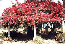 Bougainvillea outside a Bulawayo home
Geography
The city sits on a plain that marks the Highveld of Zimbabwe and is close to the watershed between the Zambezi and Limpopo drainage basins. The land slopes gently downwards to the north and northwest. The southern side is hillier, and the land becomes more broken in the direction of the Matobo Hills to the south.
 Petrea flower in a garden in Bulawayo
Climate
Due to its relatively high altitude, the city has a subtropical climate despite lying within the tropics. Under the Koppen climate classification, Bulawayo features a humid subtropical climate (Cwa), though it’s a drier version of the climate. The mean annual temperature is 19.16°C,[3] similar to Pretoria at a similar altitude but almost 600 km farther south. As with much of southern and eastern Zimbabwe, Bulawayo is cooled by a prevailing southeasterly airflow most of the year, and experiences three broad seasons: a dry, cool winter season from May to August; a hot dry period in early summer from late August to early November; and a warm wet period in the rest of the summer, early November to April. The hottest month is October, which is usually the height of the dry season. The average maximum temperature ranges from 21°C in July to 30°C in October. During the rainy season, daytime maxima are around 26°C. Nights are always cool, ranging from 8°C in July to 16°C in January.
The city's average annual rainfall is 590mm, which supports a natural vegetation of open woodland, dominated by Combretum and Terminalia trees. Most rain falls in the December to February period, while June to August is usually rainless. Being close to the Kalahari Desert, Bulawayo is vulnerable to droughts and rainfall tends to vary sharply from one year to another. In 1915, 748mm of rain fell in the three months up to February (December 1914 is the wettest month on record) while in the three months ending February 1983, only 84mm fell.
Climate data for Bulawayo Month Jan Feb Mar Apr May Jun Jul Aug Sep Oct Nov Dec Year Record high °C (°F) 36
(97)34
(93)34
(93)33
(91)31
(88)28
(82)28
(82)32
(90)36
(97)36
(97)37
(99)35
(95)37
(99)Average high °C (°F) 27
(81)27
(81)26
(79)26
(79)23
(73)21
(70)21
(70)23
(73)27
(81)29
(84)29
(84)28
(82)25.58 Average low °C (°F) 16
(61)16
(61)15
(59)13
(55)9
(48)7
(45)7
(45)9
(48)12
(54)15
(59)16
(61)16
(61)12.58 Record low °C (°F) 9
(48)8
(46)9
(48)3
(37)1
(34)−2
(28)0
(32)0
(32)3
(37)7
(45)9
(48)11
(52)−2
(28)Rainfall mm (inches) 142
(5.59)109
(4.29)84
(3.31)18
(0.71)10
(0.39)3
(0.12)0
(0)0
(0)5
(0.2)20
(0.79)81
(3.19)122
(4.8)594
(23.39)Avg. rainy days (≥ .25 mm) 14 11 9 4 2 1 1 0 1 4 10 12 69 Sunshine hours 217 224 248 270 279 300 279 310 300 279 240 248 3,194 Source: BBC Weather,[4] Economy
 Fife Street
Bulawayo has long been known as the industrial hub of Zimbabwe. It has a large manufacturing presence, and large industries such as Merlin Textiles, Zimbabwe Engineering Company (Zeco), Hubert Davies, Radar Metal Industries, National Blankets, G & D Shoes, Merlin, Tregers Group, Stewarts & Lloyds, Hunyani Holdings, Cold Storage Commission. However some of these companies have either moved operations to Harare or no longer exist altogether which has crippled Bulawayo's economy. The industries are deserted and the infrastructure has since been left to deteriorate, further deterring investors from operating in the city. The reason for the cities de-industrialization has been heralded to be the lack of infrastructure to support the size of the city and it's operations and an unreliable source of water and the collapse of the rail infrastructure which was a core reason of placing industry in Bulawayo to begin with. Many locals argue that it is because of marginalisation they experience against the government due to cultural differences between the Shona in Harare and the Ndebele Proper in Bulawayo because the National railways of Zimbabwe (Headquarters Bulawayo) is a government parastatal and as such should have been thriving had it not been for embezzlement of allocated funds by company executives who are believed to be Shona. The water issue is not new and had brought about the "help a thirsty Matabele" initiative of the 1970s and the Matabeleland Zambezi Water Project which would put an end to the water issue in Matabeleland was drafted, however this project was put on hold soon after independence. these allegations have all been labeled hogwash by the relevant authorities, however they have only fueled the secessionist initiative into a general opinion. Before the collapse of Zimbabwe's rail infrastructure, Bulawayo was an important transport hub, providing rail links between Botswana, South Africa and Zambia and promoting the city's development as a major industrial centre. The city still contains most of what remains of Zimbabwe's heavy industry and food processing capability including a Thermal Power Station which resumed operations in February 2011 after a capitalisation deal with the Government of Botswana where Bulawayo would supply 45 Megawatts in three years. Like many parts of the country, Bulawayo has for the past ten years seen a huge drop in service delivery and an increase in unemployment due to the number of resignations of people seeking better prospects across the border. Many people resorted to farming, mining and the black market for sustainance, while others depended on the little foreign currency that would be sent by family in other countries. However, with the introduction of the multi-currency system in 2009, a new approach is seen by investors in the city who admire the already available infrastructure and the huge workforce and Bulawayo as great prospects for the future and is set to once again contribute greatly to the economy of Zimbabwe. The city is served by Joshua Mqabuko Nkomo International Airport which has been expanded a number of times to cope with the influx of visitors into he region. The Edgars clothing stores are headquartered in Bulawayo. The Rovos rail run luxury train, Pride of Africa makes a stop in Bulawayo for pick up and dropping off passengers. Bulawayo is situated along the Trans-African Highway network important trade route of Cairo – Cape Town Highway. Most of the city's industries are privately owned, especially in the transport sector.
Past Mayors (after independence)
Naison Khutshwekhaya Ndlovu 1981–1983
Ald.Enos Mdlongwa 1983–1985
Ald.Nicholas Joel Mabodoko 1985–1988
Ald. Israel Gadhlula
Clr. Joshua Teke Malinga
Ald. Siwela
Japhet Ndabeni Ncube
Thaba Moyo
Sports
Bulawayo is home to the Queens Sports Club and Bulawayo Athletic Club, two of the three grounds in Zimbabwe where test match cricket has been played. It is also home to Hartsfield Rugby grounds where many international Test matches have been played. Hartsfield was developed by Reg Hart, after whom the grounds were named, and on which field many of southern Africa's greatest rugby players have competed. It is home to two large football teams, Highlanders[5] and Zimbabwe Saints. Other football teams include Railstars and Bantu Rovers.
- Barbourfields Stadium
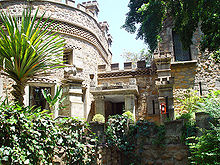 The Nesbitt Castle, Bulawayo
 - Zimbabwe International Trade Fair Grounds
- Kumalo Hockey Stadium
- Ascot Racecourse
- Khami Ruins
- Ascot Centre
- NRZ building
- Bulawayo Centre
- Nesbitt Castle
- Fidelity Life Centre
- National University of Science and Technology
- Mhlahlandlela Government Complex
Newspapers
- The Chronicle (Zimbabwe)
- The Sunday News (Zimbabwe)
- Umthunywa
- B-Metro
Sister cities
 Aberdeen, Scotland, United Kingdom
 Durban, South Africa
- Polokwane, South Africa
 Katima Mulilo, Namibia
Museums
- Natural History Museum of Zimbabwe
- National Gallery, Bulawayo
- Bulawayo Railway Museum
Suburbs and neighbourhoods
Main page: Category:Suburbs of Bulawayo- Ascot
- Adjoining the Bulawayo Ascot race-course
- Barbour Fields
- The suburb was named after a former Mayor, H. R. Barbour. A mayor who during the colonial era, was :greatly interested in the welfare of the indigenous people. There is a place called Barbour in Argyll & :Bute. Barbour is a Scottish family name, though it was apparently first recorded on the English side of :the border, in Cumbria and Northumberland. The father of Scottish vernacular poetry, John Barbour (1320-:1395), is best remembered for his epic poem "The Brus" telling the story of King Robert I. The origin of :the name is occupational (a cutter of hair as well as an extractor of teeth during the Middle Ages).
- Barham Green
- The suburb was named after two people. The first was a former Bulawayo City Councillor [ who later :became an Alderman] Mrs. M. E. Barham, M.B.E. and the other was Rev. Rufus Green. The two people were :critical in the establishment of this suburb. During the colonial Rhodesia era, the suburb was :designated for the Coloured Community
- Beacon Hill
- Also known as Beryl Drive, reference is made to fact that it is the High Point of the suburbs and :possess the areas with the highest marking beacon at its summit.
- Belmont Industrial Area
- The area was named after a former Bulawayo City Engineer, Mr. Kinmont
- Bellevue
- The suburb was named after estate name. Sometimes spelt Belle Vue. The origin of this universally :popular place name is ultimately French - 'beautiful view'.
- Belmont
- Bradfield
- The suburb was named after Mr. Edwin Eugene Bradfield, a pioneer.
- Burnside
- This area used used to be a portion of former town Council area, used be part of Matsheumhlope Farms. :Name is derived from the reference to the river Matsheumhlophe. Burn is a Scottish and northern English :word for a stream.
- Cement
- This was named after the surrounding industrial area, responsible for the making of Cement.
- Cowdray Park
- Donnington
- Donnington West
- Douglasdale
- The Douglas family, descendants of William de Duglas (late 12th Century) :was one of the most powerful in :Scotland.
- Eloana
- Emakhandeni
- Emakhandeni is the isiNdebele name for Fort Rixon, which was the area where the regiment, aMakhanda :were located. eMakhandeni is the locative term
- Emganwini
- Reference is made to the plentiful Amarula trees in the vicinity.
- Enqameni
- Enqotsheni
- Entumbane
- This is place where King Mzilikazi was buried.One of the dozens of high density suburbs of Bulawayo :commonly referred to as the "Western Suburbs". The first disturbances that led to the :Gukurahundi were sparked in Entumbane, hence the term "Impi ye Ntumbane" that refers to the :disturbances.
- Fagadola
- Famona
- The suburb was named after, Famona, one of the daughters of King Lobengula. It means jealousy or :envy must end *literally- die*
- Fortunes Gate (Including Mtaba Moya)
- The suburb name comes from the original property name, and gates are those of the original Market :Building.
- Four Winds
- The suburb name comes from the original property name, the first house was on top of a hill.
- Glencoe
- This name is etched into the Scottish psyche as the bleak glen in the Highlands where, in 1692, a party :of MacDonald men, women and children was treacherously massacred by the Campbells, who were acting under :government orders.
- Glengary
- The suburb was named after its estate name. The "Glengarry" bonnet is an oblong woollen cap, popular :amongst pipe bands.
- Glenville (Including Richmond South)
- The suburb was named after its estate name.
- Granite Park
- Greenhill
- The suburb name comes from the reference to scenery and topography.
- Gwabalanda
- Named after one of Ndebele chiefs, Gwabalanda Mathe
- Harrisvale
- Helenvale
- Highmount
- Hillcrest
- The suburb name comes from the reference to topography. It is Greenhill's Crest
- Hillside
- The suburb name comes from the reference to topography. (Greenhill's slope))
- Hillside South
- The suburb name comes from it's position as the south facing slope of Greenhill
- Hume Park
- Hume/Home is a Lowland Scottish family name.
- Hyde Park
- The name originates from the large amount of residents which trace their ancestry toEngland
- Ilanda
- Ndebele name for the Egret
- Iminyela
- The name of the type of tree common in that area.
- Intini
- The name was given as a commemoration to the Mhlanga family which originally set :out with the Khumalo family under Mzilikazi as gratitude to their contribution to the Ndebele Kingdom, Mthwakazi. the Ntini is the totem of the Mhlanga-Mabuya clan, not to be confused with the Gasela which are originally Tsonga/ Shangaan incorporated into the state
- Jacaranda
- Reference is made to the Jacaranda trees
- Kelvin (Industrial area, includes North East and West)
- The area was named in reference to a suburb of Glasgow. It takes its name from the river Kelvin, a tributary of the river Clyde.
- Kenilworth
- The suburb was named after its estate name.
- Kilallo
- Kingsdale
- The suburb was named after the Royal Clan of the Matabele
- Khumalo North
- Reference to the position of Kumalo Suburb
- Lakeside
- Lakeside is the stretch of water at the junction of the Old Essexvale Road and the road to the suburb of Waterford, and then onto Hope Fountain Mission
- Lobengula
- Named after the second and last Matabele King, Lobengula
- Lobenvale
- The suburb name is derived from a combination of King Lobengula's name and Umguza Valley
- Lochview
- The suburb name is in reference to Lakeside Dam and is famous in the city for its large Scottish residents and the Scottish style houses. According to the Bulawayo City Suburb Names website, the suburb was named in reference to Lakeside Dam
- Luveve
- Named after Ndebele chief Luveve. Established in 1935
- Mabuthweni
- The suburb name means “where the soldiers are”, the name was given in reference to a bachelor quarters.
- Magwegwe
- The suburb name is named after Magwegwe, who was one of the significant people in King Lobengula's royal Bulawayo town.
- Magwegwe North
- Reference to the position relative to that of Magwegwe.
- Magwegwe West
- Reference to the position relative to that of Magwegwe.
- The suburb got its name from the actions of Mr. Fallon, who used walk around with a stick. The name comes from the word "umakhokhoba" which was the locals referred to Fallon as, meaning “the little old man who walks with a stick” . The word actually describes the noise of the stick hitting the ground ko-ko-ko or the doors. It is the oldest African dwelling in the city. Political activism was rife pre-Zapu era.
- Mahatshula
- Mahatshula is named after one of the Ndebele Indunas. This induna's name was Mahatshula Ndiweni
- Malindela
- The suburb was named after the mother of Faluta, who was the mother of Lobengula i.e. named after Lobengula's maternal grandmother.
- Manningdale
- Named after of the developer suburb
- Marlands
- Matsheumhlope
- The name comes from the association with river (“White Stones”). White stones in Ndebele Proper and Zulu language are amatshe amhlope.
- Matshobana
- The suburb was named after Matshobana, who was a chief of the Khumalo clan and more significantly he was the father of Mzilikazi, the founder of the Ndebele Kingdom.
- Montrose
- The suburb was named by the Estate Developers and Street names are of many Cotswold Villages and towns.
- Montgomery
- named after Bernard Montgomery, 1st Viscount Montgomery of Alamein a decorated British Army commander
- Morningside
- Mpopoma
- The name comes from a descriptive Ndebele name for the area, which was derived from the sound the Mpopoma river makes when flowing.
- Munda
- The Tonga name for a plot of land on which people would farm
- Mzilikazi
- Suburb was named after the founder of uMthwakazi, King Mzilikazi.A stone's throw away from Barbourfields suburb separated by a road called Ambulance Drive that leads to one of Zimbabwe's large hospitals called Mpilo.
- New Luveve
- Reference is made to the suburb Luveve, see Luveve suburb.
- Newsmansford
- Newton
- Estate name
- Newton West
- Reference to position (Newton).
- Nguboyenja
- Named after Lobengula’s son and heir.
- Njube
- Named after one of Lobengula’s sons
- Nketa
- Named after the Traditional Heritage Site of Nketa Hill on which King Lobengula assembled his entire kingdom and divided it's citizens according to cultural ethnicity and different stages of incorporation into three groups the Zansi which is Xhosa for "south", referring to the people who left the Zulu Kingdom originally, the Enhla or Nxele which referred to the second mass incorporated group which was the Swati[disambiguation needed
 ], Pedi, Sotho with whom they settled in Mhlahlandela 1 and the final group was the Hole (English pronunciation: /ˈxɒli/), which constituted of the Shona, Kalanga and Bakwena. Most historians argued that this was clear evidence of Lobengula's lack of foresight and political tact as he was literally undoing what his father had spent his lifetime trying to achieve, a unified kingdom with a single identity.
- Nkulumane
- One of the sons of King Mzilikazi and heir, founder of the Matebele kingdom.
- North End
- Reference to direction of Suburb.
- Northvale
- Former Town Council area, reference to position and (Umguza) Valley
- Northlea
- North Lynne
- North Trenance
- Reference to position relative to that of Trenance.
- Ntaba Moyo
- Orange Grove
- Paddonhurst
- Named after Major Cecil Paddon, O.B.E., (Pioneer).
- Parklands
- Estate Name. Park Lands Estate A (Portion of original grant to Dominican Sisters).
- Parkview
- Situated on the location adjacent to the Centenary Park and proposed location of Bulawayo Zoo
- Pelandaba
- Phelandaba translates “The matter is concluded”, a reference to the successful conclusion to the struggle for security.
- Pumula
- Phumula means “A Resting Place” reference to the fact that many have built homes there to retire to.
- Pumula South
- Named in reference to relative position of Pumula
- Queensdale
- Queens Park
- A reference to the Queen and the three main roads – Victoria, Alexandra and Elizabeth
- Queens Park East
- A reference to the position relative to that of Queen Park.
- Queens Park West
- A reference to the position relative to that of Queen Park.
- Rangemore
- Suburb adopted the original estate name.
- Raylton
- Suburb adopted the original estate name.
- Richmond
- Riverside
- Derived from the original Estate name, which was in reference to the Umguza River
- Romney Park
- The suburb was named after George Romney, a British Painter
- Sauerstown
- Named after Dr. Han Sauer, original owner of the land
- Selbourne Park
- Named after the main road of Selbourne Avenue, now called L.Takawira Avenue, facing Ascot Mansions
- Sizinda
- Battle regiment of Mzilikazi of the Matabele
- Steeldale
- Composite name referring to industry.
- Suburbs
- This was the first suburb and retained that name.
- Southdale
- Souththwold
- The suburb was named by the Estate Developers and Street names are of many Cotswold Villages and towns.
- Sunninghill
- After British Royal residence (given to present Queen at time of marriage).
- Sunnyside
- Chosen from list of suggested names
- Tegela
- The name is derived from a Ndebele word ukwethekela meaning “to visit”.
- The Jungle
- Thorngrove
- Suburb name came from the large number of Mimosa (Thorn) trees in the area.
- Trenance
- Estate name
- Tshabalala
- The “isibongo” or praise name for Lobengula’s mother, Faluta, who was of Swazi extraction.
- Tshabalala Extension
- Extension in reference to the suburb of Tshabalala
- Umguza Estate
- Named after the Umguza River which runs through it
- Upper Rangemore
- Name in reference to Rangemore suburb.
- Waterford
- Estate name
- Waterlea
- Westgate
- Westondale
- West Somerton
- Willsgrove
- Windsor Park
- Named after English town or Guildford Castle grounds
- Woodlands
- Chosen from a list of suggested names
- Woodville
- Retained the old Estate Name.
Parks
- Centenary Park
- Barham Green
- Hillside Dams Conservancy
- Mabukuwene
Schools
In Bulawayo, there are 128 primary and 48 secondary schools.[8]
- Petra High School
- Petra Primary School
- Whitestone School
- Bulawayo Polytechnic College
- Christian Brothers College, Bulawayo
- Falcon College – outskirts of Bulawayo, Esigodini
- Gifford High School
- Hamilton High School
- Milton High School- ex-Zimababwean National cricketer and cricket commentator Mpumelelo Mbangwa was a student in the early 90s
- Mzilikazi Primary School- Named after the founder of the Ndebele Nation Mzilikazi
- Mzilikazi High School- situated in the popular suburb of Mzilikazi.
- National University Of Science And Technology
- Solusi University
Notable natives and residents
- Eric Bloch, Economist and columnist
- Mandla Balanda, Footballer, former Highlanders Soccer star.
- John H Abeles, physician, medical investor, philanthropist
- Marshall P. Baron, painter
- Robin Brown, cricketer
- Warren Carne, cyclist
- Brian Chikwava, writer and musician
- Charlene, Princess of Monaco, wife of Albert II, Prince of Monaco
- Charles Coghlan, lawyer, first Premier of Southern Rhodesia. (Coghlan was honored by his burial, near Cecil Rhodes's grave, at "World's View" in the Matopo Hills near Bulawayo.)
- Charles Coventry, cricketer
- Kirsty Coventry, world-record swimmer
- Chelsy Davy,girlfriend of Prince Harry
- Lucia Evans, winner of the 2006 Irish TV talent show You're A Star, born in Bulawayo
- Stanley Fischer, governor of the Bank of Israel
- Duncan Fletcher, cricketer, former coach of England national cricket team
- Humphrey Gibbs, GCVO, KCMG, farmer, Governor of the colony of Southern Rhodesia (1959–1970)
- Norman Geras, professor of political philosophy, University of Manchester; writes normblog, a widely read UK blog
- Graeme Hick, Zimbabwean-born English cricketer
- Kubi Indi, development activist and businesswoman
- Tendayi Jembere, actor
- Doris Lessing, novelist, Nobel Prize in Literature
- Cont Mhlanga, playwright and founder of Amakhosi Theater
- August Musarurwa, composer of the tune "Skokiaan"
- Benjani Mwaruwari, footballer and current Zimbabwe team captain and also turns out for Blackburn Rovers
- Peter Ndlovu, footballer, former Zimbabwe team captain and considered to be the best Zimbabwean player of all time
- Lewin Nyatanga, Zimbabwean-born Welsh footballer
- Alexander Pines, professor of chemistry, University of California, Berkeley
- Nick Price, former world number one golfer, World Golf Hall of Fame member
- Ramadu, musician
- Surendran Reddy, musician, composer and performer
- Rozalla, dance music performer
- Ron Sandler, CEO Lloyds of London; Chairman of Northern Rock bank
- Shingai Shoniwa, rock musician
- Alexander McCall Smith, CBE, FRSE, writer and Emeritus Professor of Medical Law at the University of Edinburgh, Scotland; author of The No. 1 Ladies' Detective Agency series
- Joseph Sonnabend, physician, researcher, part of team to discover interferon
- Heath Streak, cricketer and former captain of the Zimbabwe team
- Yvonne Vera, award-winning author
- David Coltart Minister of Education, Sports, Arts and Culture. (2008–present)
- Charles Mhlauri, football coach, former Zimbabwe National Team Coach (Warriors)
- David Dewar, Professor of Town Planning, University of Cape Town
- Neil Dewar, Professr of Geography, University of Cape Town
- Bruce Millar, Actor, singer, radio personality, S African Broadcasting Corporation
- Freda Keet, Actress, radio announcer at Voice of Israel, public speaker
- Yolanda Sonnabend, artist, famous London stage and costume designer
- Deborah Sharon Abeles, well known Swiss artist, with "Dessa" as artist-name
References
- ^ Google Earth
- ^ A.R.C.B. Review: A Russian Look at Rhodesia. The Journal of African history, Vol. 2. No 1 (1961), pp. 161–162 available on JSTOR
- ^ GISS Climate data, Average annual temperature 1971 to 2001
- ^ "Climate data: Average Conditions". bbc.co.uk. 28 October 2003. http://news.bbc.co.uk/weather/forecast/622?. Retrieved 01 Nov 2011.
- ^ [http://www.highlandersfc.co.za/ Highlanders FC
- ^ http://www.bulawayo1872.com
- ^ http://www.rampantscotland.com/placenames/placename_bulawayo.htm
- ^ Makoni, Albert (2007-09-06). "Health disaster looms in Bulawayo". The Zimbabwe Guardian. http://talkzimbabwe.com/default.asp?sourceid=&smenu=84&twindow=&mad=&sdetail=5507&wpage=1&skeyword=&sidate=&ccat=&ccatm=&restate=&restatus=&reoption=&retype=&repmin=&repmax=&rebed=&rebath=&subname=&pform=&sc=1705&hn=talkzimbabwe&he=.com. Retrieved 2007-11-22.[dead link]
th
External links
Subdivisions of Zimbabwe Provinces Bulawayo · Harare · Manicaland · Mashonaland Central · Mashonaland East · Mashonaland West · Masvingo · Matabeleland North · Matabeleland South · MidlandsDistricts Beitbridge · Bikita · Bindura · Binga · Bubi · Buhera · Bulawayo · Bulilimamangwe · Chegutu · Chikomba · Chimanimani · Chipinge · Chiredzi · Chirumhanzu · Chivi · Gokwe North · Gokwe South · Goromonzi · Guruve · Gutu · Gwanda · Gweru · Harare · Hurungwe · Hwange · Hwedza · Insiza · Kadoma · Kariba · Kwekwe · Lupane · Makonde · Makoni · Marondera · Masvingo · Matobo · Mazowe · Mberengwa · Mount Darwin · Mudzi · Mukumbura · Murehwa · Mutare · Mutasa · Mutoko · Muzarabani · Mwenezi · Nkayi · Nyanga · Rushinga · Seke · Shamva · Shurugwi · Tsholotsho · Umguza · Umzingwane · Uzumba-Maramba-Pfungwe · Wedza · Zaka · Zvimba · ZvishavaneWards Largest cities Categories:- Populated places established in 1871
- Populated places in Zimbabwe
- Provinces of Zimbabwe
- Bulawayo
- Barbourfields Stadium


Wikimedia Foundation. 2010.