- Noordhoek, Cape Town
-
Noordhoek, Cape Town — Neighborhood — Country  South Africa
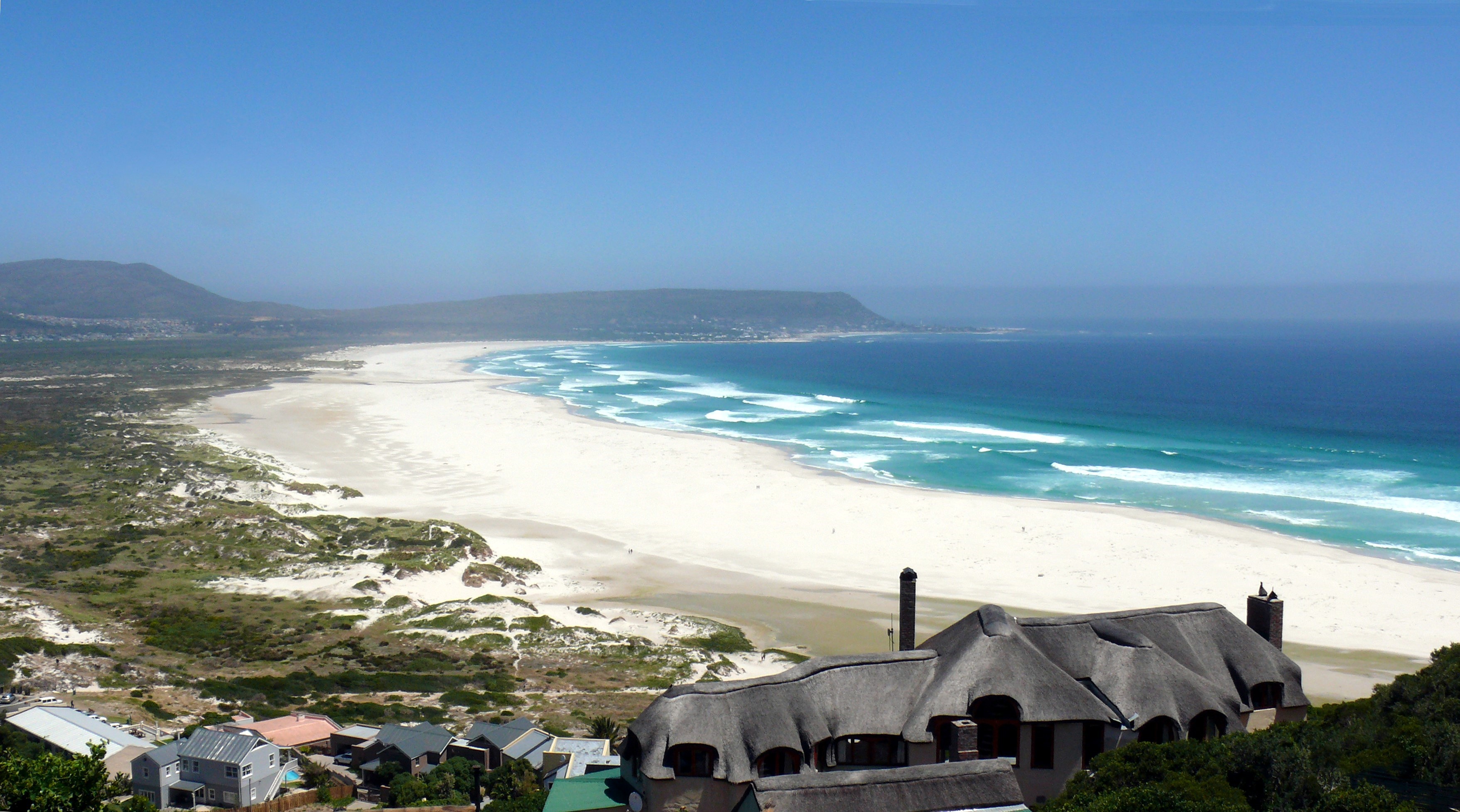
Province Western Cape Municipality City of Cape Town Wards Time zone SAST (UTC+2) Postal code  Looking north along the beach. The slopes of Chapman's Peak rise to the right at the end of the sand. The peak in the distance is Karbonkelberg, west of Hout Bay
Noordhoek is a suburb of Cape Town, South Africa, located below Chapman's Peak on the west coast of the Cape Peninsula, approximately thirty-five kilometres to the south of the city itself. The name "Noordhoek" was taken from Dutch and literally means "north corner". It is best-known for its picturesque shoreline and its long, wide, sandy beach, which stretches south to the neighbouring village of Kommetjie. Near the southern end of this beach is the wreck of the steamship "Kakapo", which ran aground about a century ago when the captain mistook Chapmans' Peak for the Cape of Good Hope and put the helm over to port. Noordhoek can be accessed either from the spectacular scenic coastal road, Chapman's Peak Drive, which leads out of Hout Bay or via the mountain road Ou Kaapse Weg which cuts through the beautiful Silvermine Nature reserve - now part of the Table Mountain National Park. Noordhoek is a small scattered community of nice houses, often with sea views and has a large horse population as riding on the long sandy beach is a great attraction. Many artists live in Noordhoek.

Coordinates: 34°06′15″S 18°21′37″E / 34.10413°S 18.36039°E
Suburbs of Cape Town City Bowl Bo-Kaap · De Waterkant · Gardens · Higgovale · Oranjezicht · Schotsche Kloof · Tamboerskloof · University Estate · Vredehoek · Walmer Estate · Woodstock · ZonnebloemNorthern Suburbs Bellville · Bothasig · Brackenfell · Brooklyn · Durbanville · Edgemead · Elsie's River · Facreton · Goodwood · Kensington · Kuils River · Maitland · Monte Vista · Panorama · Parow · ThorntonAtlantic Seaboard Bantry Bay · Camps Bay · Clifton · Fresnaye · Green Point · Hout Bay · Llandudno · Mouille Point · Sea Point · Three Anchor BaySouthern Suburbs Bergvliet · Bishopscourt · Claremont · Constantia · Diep River · Heathfield · Kenilworth · Mowbray · Newlands · Observatory · Pinelands · Plumstead · Retreat · Rondebosch · Rondebosch East · Rosebank · Salt River · Steenberg · Tokai · WynbergSouth Peninsula Capri Village · Clovelly · Fish Hoek · Glencairn · Kalk Bay · Kommetjie · Masiphumelele · Muizenberg · Noordhoek · Ocean View · Scarborough · Simon's Town · St James · Sunnydale · Sun ValleyCape Flats Athlone · Belhar · Blue Downs · Bonteheuwel · Crawford · Crossroads · Delft · Elsie's River · Epping · Grassy Park · Gugulethu · Khayelitsha · Langa · Lansdowne · Lotus River · Manenberg · Mfuleni · Mitchell's Plain · Nyanga · Ottery · Philippi · WettonFalse Bay West Coast Categories:- Suburbs of Cape Town
- Western Cape geography stubs

Wikimedia Foundation. 2010.