- Claremont, Cape Town
-
Claremont — Suburb — Aerial view of the Claremont Central business district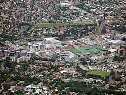 Street map of Claremont
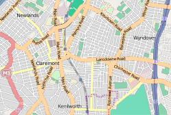 Location in the Cape Town metropolitan area
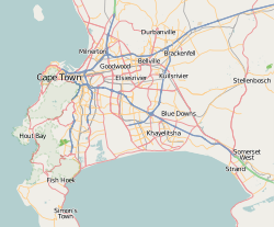
 Claremont
Coordinates: 33°58′50″S 18°27′55″E / 33.98056°S 18.46528°ECoordinates: 33°58′50″S 18°27′55″E / 33.98056°S 18.46528°E Country  South Africa
Province Western Cape Municipality City of Cape Town Wards 58, 59 Government[1] – Councillor Owen Kinahan (Ward 58) (DA) – Councillor Ian Iversen (Ward 59) (DA) Population (2001)[2] – Total 14,531 Ethnic groups – Black African 6.62% – Coloured 9.27% – Indian or Asian 3.76% – White 80.35% Languages – English 87.83% – Afrikaans 5.97% – Xhosa 2.68% Time zone SAST (UTC+2) Postal code 7708 Website www.claremontcentral.co.za Claremont is a suburb of Cape Town, South Africa. It is situated six miles south of the city, and is one of the so-called "Southern Suburbs". It is an important commercial and residential area, which is currently experiencing significant growth and development.
Contents
History
Until the arrival of Dutch colonists in 1652, the uncultivated veld of the Cape Peninsula was used by the nomadic Khoisan to grazed their cattle. The Dutch established an outpost on the shore of Table Bay, and in 1657 they established a number of farms south of the outpost. The most southerly of those original farms, named Louwvliet and Questenburg, are today covered by Claremont and the adjoining suburb of Newlands.
The area was agricultural for about 150 years. Other estates that were established included Veldhuyzen in 1676, Stellenberg in 1697, Weltevreden (originally part of Stellenberg) in 1730, Sans Souci (originally part of Questenburg) in 1786, and The Vineyard in 1798. They produced grain and grapes, and some farmers made wine.
After the colony had been taken over by the British in 1814, the area gradually changed its character. British settlers and officials bought the farms, re-named some of them, and turned them into country residences. Weltevreden was subdivided in 1822, and a portion of it was renamed Claremont, a name later applied to the whole area.
The distinguished British astronomer Sir John Herschel put Claremont on the map by living at Feldhausen (formerly Veldhuyzen) from 1834 to 1838. A village began to develop, and by 1840 it had been named Claremont.
Village (1840–1886)
The village grew during the 1840s and 1850s. Public transport consisted of horse-drawn omnibuses which plied along the Main Road from 1837 until the railway was opened in 1864 [3].
Politician Sir JC Molteno owned Claremont House from 1863 to 1886. He was later the Cape Colony's first prime minister.
The opening of the railway from Cape Town to Wynberg in 1864 spurred subdivision and development. The Feldhausen estate (also known as "The Grove") was subdivided in 1869–1870).
A new Congregational Church was built on the Main Road in 1877. The Claremont Hall was opened in 1879.
The land along Lansdowne Road east of the railway line was subdivided and developed from 1882, creating a large residential area which is now known as "Harfield Village".
Municipality (1886–1913)
In 1882, a village management board was formed, and in 1886 it was replaced by the Municipality of Claremont, which managed neighbouring Newlands too. The privately owned Claremont Hall was taken over as a town hall. The first telephone system was installed in the early 1880s.
There was further residential development, with the subdivision of the Claremont House, Lansdowne, Milburn House, and Paradise estates in the 1890s. An electricity power station was built, and an electric tramway service was introduced in 1897.
The housing boom which followed the Anglo-Boer War saw the subdivision of further estates in the 1900s. Most streets were named in 1903–1904, many of them thematically (e.g. after saints, explorers, British counties and towns, American presidents, and British politicians)[4].
Suburb (1913– )
In 1913, Claremont and several other municipalities were incorporated into the city of Cape Town.
Considerable residential growth took place in the 1920s and 1930s, when estates such as Palmyra, Keurboom, Ravensworth, Sanatorium Estate, The Vineyard, Wyndover, and Edinburgh Estate were subdivided and developed. An additional railway station, named "Harfield Road", was built in 1931.
The government enforced its apartheid system on Claremont in the 1960s, forcing the Coloured residents to leave. As a result, large areas of the suburb stood derelict for several years.
Claremont remained predominantly residential until the early 1970s, when commercial development began. A major shopping mall, named Cavendish Square, was opened in 1973, and other shopping centres followed.
There was a further building boom in the 1990s, and the suburb is currently experiencing another, which includes the construction of three large apartment blocks, a hotel, two office blocks, the re-modeling of three other commercial buildings, and the construction of a transport interchange and a bypass road.
Places of worship
 Claremont Congregational Church (founded in 1840) in 2010
Claremont places of worship, past and present:
- Claremont Congregational Church (1840- )
- Claremont Mosque [5] (1851- )
- St Saviour's Church (Anglican) [6] (1854- )
- St Matthew's Church (Anglican) [7] (1888- )
- Claremont Methodist Church [8] (1890s- )
- Salvation Army Claremont Temple (1898–1972)
- Claremont Baptist Church [9] (1902- )
- Claremont Hebrew Congregation [10] (1904- )
- New Apostolic Church (1905- )
- Old Apostolic Church[11]
- Al-Jamiah Mosque (1911- )
- Seventh Day Adventist Church
- St Ignatius Church (Roman Catholic) (1934- )
- Claremont East Congregational Church (1932- )
- Harvey Road Mosque
- Christ the King (Anglican) (1941- )
- St Stephen's Church (Anglican) (1941- )
- Dutch Reformed Church (1941–1991)
- St Bernard's Church (Roman Catholic) (1955- )
- Christian Science Church (1959- )
- Assembly of God
- Church of the Nazarene (1975- )
Schools
Some Claremont schools, past and present:
- Mrs Harris's (later Mrs Midgley's) seminary (1840–1849)
- St Saviour's Grammar School (1878–1885) – incorporated into Grove Primary School
- Grove Primary School (1885- )
- Claremont Primary school[12] (1892- )
- Union College (1893- ) – moved to Somerset West in 1919 and was renamed Helderberg College
- Western Province Primary School [13] (1913- )
- Talfalah Institute (1917- ) – moved to Athlone in the 1971
- Herschel Girls School (1922- )
- Lady Buxton Children's Home (1923- )
- Livingstone High School (1926- )
- Rosmead Central Primary School (1940- )
- Barkly House (1945- )
- Batavia School
- Oasis Association (1952- )
- Greenfields School (1957- )
- Bel Porto School for Severely Mentally Handicapped [14]
- Abbott's College[15]
Commerce and industry
Some Claremont businesses, past and present:
- Orchard's Hotel (later Crown Hotel) (1836-c1969)
- Lansdowne (later Claremont) Hotel (1880s-2001)
- F.J. Pearce & Co (1882–1966)
- Hall's Pharmacy (1892-1970s)
- Vineyard Hotel (1893- )
- Henshilwoods (1894–1998)
- Brenner's Stores (1904- )
- Pavilion Cinema (closed 1930s)
- Star (later Orpheum) Cinema (closed 1960s)
- Scala (later Protea) Cinema (1938–19..)
- Cavendish Square shopping mall (1973- )
- Werdmuller Centre shopping mall (1975- )
- Kenilworth Centre shopping mall (1974- )
- The Atrium (now Stadium-on-Main) shopping centre (1990- )
- Heritage College
- Cape Town School of English [16]
- Cape Town International School of Languages
- Adèle Beauty Therapy School
- Cape Town School of Eurythmy [17]
- School of Practical Philosophy [18]
Many national banks and chains of shops have branches in Claremont.
Sport
Some Claremont sports clubs and facilities, past and present:
- Claremont Cricket Club (1876- ) – no longer in Claremont
- Kenilworth Racecourse (1882- ) – Kenilworth later became a suburb in its own right
- Violets Rugby Club (c1886- ) – moved to Crawford in the 1970s[19]
- Villagers' Rugby Football Club (1875 -) – moved to Claremont from Mowbray in 1898.
- Claremont Swimming Baths (1895-1960s)
- Claremont Tennis Club (1908- )
- Rosmead Sports Ground (1921- )
- Cape Technical College Grounds (1927- )
- Ackerman's Sports Grounds (now Impala Park) (1920s- )
- Celtic Harriers Athletics Club (1970- )
Medical
Claremont's first medical facility may have been the temporary isolation hospital set up during the 1882 smallpox epidemic. Other medical facilities, past and present:
- Claremont Medical & Surgical Sanatorium (1896–1901
- Kingsbury Maternity Home (1945- )
- Claremont Medical Centre (1970- ) – on the old Crown Hotel site
- Kingsbury Hospital (1990s- )
Public amenities
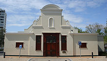 The Cape Dutch style Claremont Civic Centre in 2010
- Claremont Post Office (1846- )
- Claremont Town Hall (1879–1946)
- Claremont Library (1897- )
- Arderne Gardens (1927- )
- Clareinch Nurses' War Memorial Home (1934- ) – moved to Pinelands in the 1960s
- Janet Bourhill Institute (1944- ) – moved to Bonteheuwel in the 1970s
- Clareinch Post Office (1936- )
- Claremont Civic Centre (1960- )
See also
- ^ "Cape Town city Councillors by ward". City of Cape Town. http://web1.capetown.gov.za/web1/newcitycouncil/councilsearch.asp. Retrieved 16 September 2010.
- ^ "Claremont". Census 2001. City of Cape Town. http://www.capetown.gov.za/en/stats/2001census/Documents/Claremont.htm. Retrieved 6 February 2010.
- ^ Coates, P.R. (1976). Track and Trackless
- ^ Hart, P.H. (1999) Claremont, Newlands and Bishopscourt Street Names
- ^ Gamildien, F. (2004) Claremont Main Road Mosque
- ^ Langham-Carter, R.R. (1973) Under the Mountain
- ^ Thomas, L.R. (1993) St Matthew's Church
- ^ Anon (1979). Claremont Cavalcade
- ^ Tudor, D. (1980) Claremont Baptist Church 1905–80
- ^ Claremont Wynberg Hebrew Congregation (Kehillat Agudat Achim)
- ^ Old Apostolic Church Congregation, Claremont
- ^ Claremont Primary School
- ^ Western Province Primary School
- ^ Bel Porto School
- ^ Abbotts College
- ^ Cape Town School of English
- ^ Cape Town School of Eurythmy
- ^ School of Practical Philosophy
- ^ Booley, A. (1998) Forgotten Heroes
Suburbs of Cape Town City Bowl Bo-Kaap · De Waterkant · Gardens · Higgovale · Oranjezicht · Schotsche Kloof · Tamboerskloof · University Estate · Vredehoek · Walmer Estate · Woodstock · ZonnebloemNorthern Suburbs Bellville · Bothasig · Brackenfell · Brooklyn · Durbanville · Edgemead · Elsie's River · Facreton · Goodwood · Kensington · Kuils River · Maitland · Monte Vista · Panorama · Parow · ThorntonAtlantic Seaboard Bantry Bay · Camps Bay · Clifton · Fresnaye · Green Point · Hout Bay · Llandudno · Mouille Point · Sea Point · Three Anchor BaySouthern Suburbs Bergvliet · Bishopscourt · Claremont · Constantia · Diep River · Heathfield · Kenilworth · Mowbray · Newlands · Observatory · Pinelands · Plumstead · Retreat · Rondebosch · Rondebosch East · Rosebank · Salt River · Steenberg · Tokai · WynbergSouth Peninsula Capri Village · Clovelly · Fish Hoek · Glencairn · Kalk Bay · Kommetjie · Masiphumelele · Muizenberg · Noordhoek · Ocean View · Scarborough · Simon's Town · St James · Sunnydale · Sun ValleyCape Flats Athlone · Belhar · Blue Downs · Bonteheuwel · Crawford · Crossroads · Delft · Elsie's River · Epping · Grassy Park · Gugulethu · Khayelitsha · Langa · Lansdowne · Lotus River · Manenberg · Mfuleni · Mitchell's Plain · Nyanga · Ottery · Philippi · WettonFalse Bay West Coast References
In addition to the sources cited in the footnotes:
- Field, S. (Ed) (2001). Lost Communities, Living Memories.
- Henshilwood, N. (1972). A Cape Childhood.
- Louw, J. & Malan L. (1984). The Louws of Louwvliet.
- Murray, J. (1958). Claremont Album.
- Playne, S. (1911). Cape Colony – Its Commerce, Industry and Resources.
- Tredgold, A. (1990). The Ardernes and their Garden.
Categories:- Suburbs of Cape Town


Wikimedia Foundation. 2010.