- McAdam, New Brunswick
-
McAdam — Village — Saunders Road in McAdam with the McAdam railway station in the background.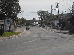
Motto: "Discover History and National Pride" Location of McAdam within New Brunswick.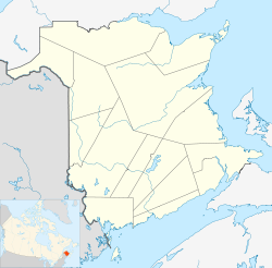
 McAdam
Coordinates: 45°35′53″N 67°19′35″W / 45.59815°N 67.32628°W Country  Canada
Province  New Brunswick
County York County Incorporated 1966 Named for John McAdam Government – Type Municipal council – Mayor Frank Carroll Area – Land 14.47 km2 (5.6 sq mi) Elevation 146 m (479 ft) Population (2006) – Total 1,404 – Density 97.1/km2 (251.5/sq mi) Time zone Atlantic (AST) (UTC−4) – Summer (DST) Atlantic Daylight Time (ADT) (UTC−3) Canadian Postal code E6J Area code(s) 506 NTS Map 021G11 GNBC Code DBAQZ Website http://www.mcadamnb.com 
McAdam is a village located in the southwestern corner of York County, New Brunswick, Canada. The village covers 14.47 square kilometres (5.59 sq mi) and has a population of 1,404 as of 2006.[1]
The area was first settled in the mid-to-late 19th century as a group of small lumber camps. The area further developed due to its advantageous location as an important railway junction between the main line of the Canadian Pacific Railway from the Maritime provinces to New England and central Canada and branch lines to St. Stephen, St. Andrews and Woodstock. The town was an important servicing stop for many passenger and freight trains, as well as military trains during the World Wars. A large railway station was built to accommodate travelers and a roundhouse and yard were located in the village. The conversion of locomotives from steam power to diesel during the 1950s, as well as highway improvements and increased trucking during the 1960s and 1970s, saw McAdam decline in importance for rail transport. Decreased employment with the railway caused significant economic challenges for the community during the latter half of the 20th century and early 21st century.
Contents
History
For more details on this topic, see McAdam railway station.Original settlement of present-day McAdam area began sometime between 1857 and 1869, after the establishment of the St. Andrews and Quebec Railway (SA&Q).[2] McAdam began under the name of City Camp which was originally a collective of several lumbering encampments which sprung up alongside the line. By the late 1860s the European and North American Railway's "Western Extension" was completed. This line joined the SA&Q line (by now part of the New Brunswick Railway) in City Camp; as a result City Camp was renamed to McAdam Junction after John McAdam a prominent lumberman and politician, who had numerous land grants in the Canterbury and Dumfries parishes at that time.[3]
By 1871 McAdam was a junction of limited importance and this contributed to a rise in population to about four hundred people, mostly railroad workers and their families. In 1894 the parishes of Prince William and Dumfries were merged into a new parish known as the Parish of McAdam. In 1889 the Canadian Pacific Railway (CPR) built the International Railway of Maine the final link making it the first transcontinental railway, the following year the CPR leased the New Brunswick Railway for nine-hundred-ninety-nine years. The CPR began an ambitious construction project on a massive station/hotel at the junction in 1900, construction was completed in 1901, and expanded in 1911. The station became the dominant feature of the settlement and would go on to be a major employer for the junction heralding in a period of growth.[3]
World War I and II both had a staunch impact on the community. Trains carrying soldiers east to ports such as Halifax passed through McAdam. Trains often stopped for inspection and servicing at the station and demand for workers caused the population in the town to continue to rise. In 1915 a German agent, Werner Horn, attempted to destroy the international railroad bridge between Vanceboro, Maine and St. Croix, New Brunswick - immediately west of McAdam - in order to limit the movements of war supplies to the port of Saint John. His attempt proved futile as the bridge was not severely damaged and was returned to service several days later.[3]
The change from steam locomotives to diesel locomotives during the 1950s proved to be devastating for McAdam's economy. Trains no longer needed to stop as frequently for service and the railway station in McAdam lost the importance it once had. New highways constructed after the war saw trucks and automobiles reduce the need for the branch lines to St. Stephen, St. Andrews and Woodstock. Local passenger trains from McAdam to these destinations were canceled in the early 1960s leaving The Atlantic Limited as McAdam's only remaining passenger train. These changes in turn caused the station's hotel to close later in the decade.
Already suffering from new technological developments and its isolation from any other reliable source of employment, McAdam was devastated after the CPR transferred operation of passenger service to Via Rail Canada in 1978.[a] In 1981 Via cancelled the Atlantic although it was revived in 1985 before being permanently cancelled in December 1994 whereby CPR closed the station. In January 1995 CPR transferred ownership of the building to the village at the same time as it sold its rail lines through the village to the New Brunswick Southern Railway.
Recent fundraising efforts by the village has resulted in renovations and restoration efforts for the station which is now a museum and tourist attraction for the community. The village hosted the 2009 New Brunswick Day in an effort to generate awareness of the community's rich history.[4]
Geography and climate
McAdam is located in the New Brunswick Highlands.
Climate data for McAdam Month Jan Feb Mar Apr May Jun Jul Aug Sep Oct Nov Dec Year Average high °C (°F) −3.9
(25.0)−2.2
(28.0)2.4
(36.3)9.4
(48.9)16.7
(62.1)22.3
(72.1)24.9
(76.8)23.7
(74.7)19.2
(66.6)13.2
(55.8)−5.7
(21.7)−1.5
(29.3)10.8 Average low °C (°F) −15.6
(3.9)−15.6
(3.9)−9.2
(15.4)−2.2
(28.0)3.5
(38.3)8.9
(48.0)12.2
(54.0)11.0
(51.8)6.4
(43.5)−1.4
(29.5)−3.6
(25.5)−12
(10)−1.2 Precipitation mm (inches) 38.8
(1.528)36.3
(1.429)33.3
(1.311)64.9
(2.555)88.4
(3.48)86.1
(3.39)93.3
(3.673)96.0
(3.78)99.0
(3.898)92.4
(3.638)107.1
(4.217)62.1
(2.445)1,176.8
(46.331)Source: Industry and Labour Adjustment Committee, McAdam, New Brunswick[5] Demographics
Year Population 1901 714 1911 1,111 1921 1,614 1931 1,946 1941 2,265 1951 2,611 1956 2,803 1961 2,669 1966 2,448 1971 2,224 1981 1,857 1991 1,600 1996 1,570 2001 1,513 2006 1,404 The first recorded population of McAdam came from the 1901 census, recording a population of 714 people. Over the next half century as the rail operations in McAdam expanded, the population increased substantially; a result of the promise of employment. The population peaked in 1956 at 2,803 people, nearly four times that of the 1901 census.[6] However, with the collapse of the rail industry in the village, the employment prospects dried up. Isolated, with no new source of jobs the population began a steady decline, a process which has continued up to the present. Fifty years since its peak population, the amount of persons living in McAdam has been nearly halved.
Economy
Economy (2006)[1] Rate Village Province Unemployment rate 14.5% 10.0% Participation rate 57.7% 63.7% Infrastructure
Education
Culture and recreation
- Amethyst Theatre
Politics
Notes
- ^[a] The CPR retained ownership of the station.
References
- ^ a b "McAdam Community Profile". Statistics Canada. http://www12.statcan.ca/census-recensement/2006/dp-pd/prof/92-591/details/page.cfm?B1=All&Code1=1310006&Code2=13&Custom=&Data=Count&Geo1=CSD&Geo2=PR&Lang=E&SearchPR=01&SearchText=McAdam&SearchType=Begins. Retrieved 2009-09-13.
- ^ York, Robert M. (1974). An International Community on the St. Croix (1604-1930). University of Maine.
- ^ a b c Bruce, J. G. (1979). The History of McAdam 1871-1977. McAdam Senior Citizens Historical and Recreational Club.
- ^ "History relived in McAdam on New Brunswick Day". Times & Transcript. 2009-08-04. http://timestranscript.canadaeast.com/search/article/749840. Retrieved 2009-09-14.
- ^ "Business Development Data: McAdam & Area". Industry and Labour Adjustment Committee. McAdam, New Brunswick. 1982-11-15.
- ^ "A Study of Accommodation Requirements in McAdam". The McAdam Research Project. McAdam, New Brunswick. 1972-05-16.
External links
Buildings McAdam Railway Station, Amethyst Theatre, McAdam High School, McAdam Elementary SchoolPeople Subdivisions of New Brunswick Subdivisions Cities Villages Alma · Aroostook · Atholville · Baker Brook · Balmoral · Bas-Caraquet · Bath · Belledune · Bertrand · Blacks Harbour · Blackville · Cambridge-Narrows · Canterbury · Cap-Pelé · Centreville · Charlo · Chipman · Clair · Doaktown · Dorchester · Drummond · Eel River Crossing · Fredericton Junction · Gagetown · Grand Manan · Grande-Anse · Grande-Digue · Harvey Station · Hillsborough · Kedgwick · Maisonnette · McAdam · Meductic · Memramcook · Millville · Minto · Neguac · New Maryland · Norton · Paquetville · Perth-Andover · Petit-Rocher · Petitcodiac · Plaster Rock · Pointe-Verte · Port Elgin · Rexton · Riverside-Albert · Rivière-Verte · Rogersville · Saint-Antoine · Sainte-Anne-de-Madawaska · Saint-François-de-Madawaska · Saint-Hilaire · Saint-Isidore · Saint-Léolin · Saint-Louis-de-Kent · Sainte-Marie-Saint-Raphaël · St. Martin's · Salisbury · Stanley · Sussex Corner · Tracy · Tide HeadCategories:- Villages in New Brunswick
- Communities in York County, New Brunswick


Wikimedia Foundation. 2010.