- Narrandera Shire
-
Narrandera Shire
New South Wales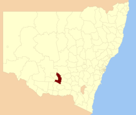
Location in New South WalesPopulation: 6,262(2009)[1] Established: 1960 Area: 4116.02 km² (1,589.2 sq mi) [2] Mayor: Wesley Hall Council Seat: Narrandera (141 East Street)[3] Region: Riverina State District: Murrumbidgee Federal Division: Riverina LGAs around Narrandera Shire: Carrathool Bland Coolamon Leeton Narrandera Shire Wagga Wagga Murrumbidgee Urana Lockhart Narrandera Shire is a local government area in New South Wales, Australia in the Riverina region. It is on the Sturt and Newell Highways.
The Shire includes the town of Narrandera and the villages of Grong Grong, Binya and Barellan.
The present Narrandera Shire was formed on 1 January 1960. This was by an amalgamation of the previous Narrandera Municipality and part of the Yanko Shire. The first Narrandera Municipality was incorporated on 18 March 1885. Narrandera Shire is a large shire in the geographical centre of the Riverina, with over 1000 kilometres of roads within its boundaries.
Mayors of Narrandera:
- R H Ferrier (1885)
- Henry Daniel Adams (1886)
- J Armstrong (1887)
Council
Narrandera Shire Council is composed of nine councillors elected proportionally. The mayor is not directly elected.[4] The current makeup of the council is as follows:[4]
Party Councillors Independents and Unaffiliated 9 Total 9 The current council, elected in 2008, is:[4]
Councillor Party Notes Wesley Hall Unaffiliated Mayor Troy Lee Unaffiliated Kevin Morris Independent Graham Eipper Independent Jenny Clarke Independent Michelle Kilgower Unaffiliated Peter Gunn Independent Jason Lee Independent Elected on Troy Lee's ticket Bob Manning Unaffiliated References
- ^ Australian Bureau of Statistics (30 March 2010). "Regional Population Growth, Australia, 2008–09". http://www.abs.gov.au/ausstats/abs@.nsf/Latestproducts/3218.0Main%20Features42008-09?opendocument&tabname=Summary&prodno=3218.0&issue=2008-09&num=&view=. Retrieved 3 June 2010.
- ^ "Narrandera Regional Profile". Riverina Regional Development Board. http://www.rrdb.com.au/rivprofile/narrandera.htm. Retrieved 2008-08-28.
- ^ "Narrandera Shire Council". Department of Local Government. http://www.dlg.nsw.gov.au/dlg/dlghome/dlg_CouncilContactDetails.asp?slacode=5800. Retrieved 2006-12-01.
- ^ a b c "Narrandera Shire Council". 2008 Election results. Electoral Commission NSW. http://www.lg.elections.nsw.gov.au/LGE2008/result.Narrandera.html. Retrieved 2009-08-03.[dead link]
Coordinates: 34°45′S 146°33′E / 34.75°S 146.55°E
Barellan · Binya · Colinroobie · Corobimilla · Grong Grong · Kamarah · Kywong · Moombooldool · Narrandera
Main Article: Local Government Areas of New South WalesLocal Government Areas of the Riverina Cities: Albury · Griffith · Wagga Wagga
Towns: Deniliquin
Shires: Balranald · Berrigan · Carrathool · Conargo · Coolamon · Cootamundra · Corowa · Greater Hume · Gundagai · Hay · Jerilderie · Junee · Leeton · Lockhart · Murray · Murrumbidgee · Narrandera · Temora · Tumbarumba · Tumut · Urana · Wakool
Local Government Areas of New South Wales Metropolitan Sydney Inner SydneyAshfield · Botany Bay · Burwood · Canada Bay · Canterbury · Hurstville · Kogarah · Lane Cove · Leichhardt · Manly · Marrickville · Mosman · North Sydney · Randwick · Rockdale · Strathfield · Sydney · Waverley · Willoughby · WoollahraOuter SydneyAuburn · Bankstown · Blacktown · Camden · Campbelltown · Fairfield · The Hills · Holroyd · Hornsby · Hunter's Hill · Ku-ring-gai · Liverpool · Parramatta · Penrith · Pittwater · Ryde · Sutherland · WarringahSydney SurroundsMid North Coast Bellingen · Clarence Valley · Coffs Harbour · Greater Taree · Kempsey · Nambucca · Port Macquarie-Hastings · Lord Howe IslandMurray Murrumbidgee Carrathool · Coolamon · Cootamundra · Griffith · Gundagai · Hay · Junee · Leeton · Lockhart · Murrumbidgee · Narrandera · Temora · Wagga WaggaHunter Cessnock · Dungog · Gloucester · Great Lakes · Lake Macquarie · Maitland · Muswellbrook · Newcastle · Port Stephens · Singleton · Upper HunterIllawarra Richmond Tweed Southeastern Bega · Bombala · Boorowa · Cooma-Monaro · Eurobodalla · Goulburn Mulwaree · Harden · Palerang · Queanbeyan · Snowy River · Tumut · Upper Lachlan · Yass Valley · YoungNorthern Armadale Dumaresq · Glen Innes-Severn · Gunnedah · Guyra · Gwydir · Inverell · Liverpool Plains · Moree Plains · Narrabri · Tamworth · Tenterfield · Uralla · WalchaCentral West North Western Far West Categories:- Populated places established in 1960
- 1960 establishments in Australia
- Local Government Areas of New South Wales
- Local Government Areas of the Riverina, New South Wales
- Riverina geography stubs

Wikimedia Foundation. 2010.