- City of Fairfield
-
City of Fairfield
New South Wales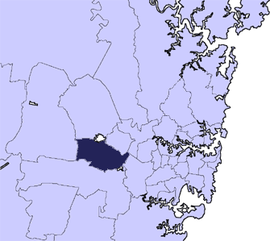
Population: 194,543(2009)[1] • Density: 1850/km² (4,791.5/sq mi) Area: 102 km² (39.4 sq mi) Mayor: Nick Lalich Council Seat: Wakeley Region: Metropolitan Sydney State District: Cabramatta, Fairfield, Smithfield, Liverpool Federal Division: McMahon, Fowler, Blaxland LGAs around City of Fairfield: City of Penrith City of Blacktown City of Holroyd City of Penrith City of Fairfield City of Parramatta City of Liverpool City of Liverpool City of Bankstown The City of Fairfield is a Local Government Area in the south-west of Sydney, in the state of New South Wales, Australia.
Contents
Suburbs in the local government area
Suburbs in the City of Fairfield are:
- Abbotsbury
- Bonnyrigg
- Bonnyrigg Heights
- Bossley Park
- Cabramatta
- Cabramatta West
- Canley Heights
- Canley Vale
- Carramar
- Cecil Park
- Edensor Park
- Fairfield
- Fairfield East
- Fairfield Heights
- Fairfield West
- Greenfield Park
- Horsley Park
- Lansvale
- Mount Pritchard
- Old Guildford
- Prairiewood
- Smithfield
- St Johns Park
- Villawood
- Wakeley
- Wetherill Park
- Yennora
History
For more than 30,000 years, Aboriginal people from the Cabrogal-Gandangara tribe tribe have lived in the area.
European settlement began early in the 19th century and was supported by railway construction in 1856. At the turn of the century the area had a population of 2,500 people and with fertile soils, produced crops for distribution in Sydney.
Rapid population increase after World War II saw the settlement of many ex-service men and European migrants. Large scale Housing Commission development in the 1950s swelled the population to 38,000. By 1979, the population had reached 120,000 and the City was becoming one of the larger Local Government Areas in New South Wales.
On 4 September 2006, Fairfield Council announced that it had banned spitting in public, which is now punishable with a fine of up to $1100. This is the only ruling of its kind in New South Wales. This also applies to people who spit their chewing gum onto the floor.
Council
Fairfield City Council is composed of twelve councillors elected proportionally, in addition to the mayor, who is elected directly. The city is divided into three wards, each electing four councillors.[2] The current makeup of the council, including the mayor, is as follows:[2]
Party Councillors Australian Labor Party 8 Liberal Party of Australia 4 Independent 1 Total 13 The current council, elected in 2008, is:[2]
Ward Councillor Party Mayor Nick Lalich Labor Cabravale Han Huynh Labor Joe Molluso Liberal Sarah Trapla Labor Nhan Tran Independent Fairfield Lawrence White Labor Zaya Toma Liberal Albert Mooshi Labor Frank Carbone Labor Parks Anwar Khoshaba Labor Frank Oliveri Liberal Sam Yousif Labor Andrew Rohan Liberal Population
The City of Fairfield is home to approximately 190,000 people, making it New South Wales' fifth largest Local Government Area and the third largest in the Sydney metropolitan area (after the City of Blacktown and Sutherland Shire).
A large portion of Fairfield's residents are migrants and their descendants. Originally, most of the migrants were Italian or from the former Yugoslavia, such as Serbian, Bosnian and Croatian. Later arrivals were from Vietnam which sparked the crime gang 5T, then came migrants from Cambodia and Laos, followed by South Americans (Argentina, Chile and Uruguay), and Assyrian/Lebanese. In recent years, an influx of African people has begun in the area. Fairfield is considered one of the most ethnically diverse suburbs in the entire world.
Large Assyrian, Bosnian, Croatian, Serbian, Filipino, Italian and Spanish (Argentinean, Chilean and Uruguayan) speaking populations reside in Fairfield and surrounding suburbs such as Bossley Park, Wetherill Park and Smithfield.
While Fairfield City has a comparatively young population with many young families, the greatest growth is occurring in the number of older residents, those aged 65 years or more.
Land Use
Fairfield City is mainly residential in nature with large-scale industrial estates at Wetherill Park and Smithfield. There are four major business and retail centres at Fairfield, Cabramatta, Bonnyrigg and Prairiewood, as well as a large number of suburban shopping malls. Fairfield has three major shopping malls; Fairfield Forum, Neeta City and Fairfield Chase. There has been significant development in Neeta city with greater commercial opportunities. Due to Fairfield's culturally diverse population there are over twenty different multicultural cafés and restaurants including Bosnian, Italian, Assyrian, Spanish and Thai.
Large expanses of rural land characterise the suburbs of Horsley Park and Cecil Park. There are 580 parks (60 of which are major parks) and the new Western Sydney Regional Parklands.
Environment
Much of the original bushland cover within the City has been cleared through past land management practices. A few small areas of this original bushland remain, including examples of Cumberland Plain vegetation, which is listed under the Threatened Species Conservation Act.
Eight creeks, 80 kilometres in length, have their headwaters in Fairfield City and flow into the Georges River and Hawkesbury Nepean catchments. The impact of development over the past 50 years has resulted in severe degradation of the natural habitat in the creek banks and water quality has been assessed as very poor in recent years. Strategies are being implemented so that this trend is being reversed.
Air quality in the City is heavily impacted upon by an insufficiently integrated public transport system, creating an over reliance upon private vehicles for moving people and freight.
Schools
Schools in the City of Fairfield include: Fairfield Public School, Fairfield High School, St Johns Park High School, Westfields Sports High School, Fairvale High School, Yennora Public School, Canley Vale High School and many more. There are also many Catholic Schools such as: Patrician Brothers' College, Our Lady of the Rosary Primary School, Mary Mackillop College, Freeman Catholic College, Sacred Heart School, St Hurmizd's Assyrian primary school and Mar Narsai Assyrian college.
Culture
Fairfield has two major local newspapers, The Fairfield Advance and the Fairfield Champion which are published every Wednesday.
Sister cities
 Hsinchu City, Taiwan (1994)
References
- ^ Australian Bureau of Statistics (30 March 2010). "Regional Population Growth, Australia, 2008–09". http://www.abs.gov.au/ausstats/abs@.nsf/Latestproducts/3218.0Main%20Features42008-09?opendocument&tabname=Summary&prodno=3218.0&issue=2008-09&num=&view=. Retrieved 3 June 2010.
- ^ a b c "Fairfield City Council". 2008 Election results. Electoral Commission NSW. http://www.lg.elections.nsw.gov.au/LGE2008/result.Fairfield.html. Retrieved 2009-06-16.[dead link]
External links
Regions of Sydney Local Government Areas of Sydney Ashfield · Auburn · Bankstown · Blacktown · Botany Bay · Burwood · Camden · Campbelltown · Canada Bay · Canterbury · Fairfield · The Hills · Holroyd · Hornsby · Hunter's Hill · Hurstville · Kogarah · Ku-ring-gai · Lane Cove · Leichhardt · Liverpool · Manly · Marrickville · Mosman · North Sydney · Parramatta · Penrith · Pittwater · Randwick · Rockdale · Ryde · Strathfield · Sutherland · City of Sydney · Warringah · Waverley · Willoughby · WoollahraList of Sydney suburbs Local Government Areas of New South Wales Metropolitan Sydney Inner SydneyAshfield · Botany Bay · Burwood · Canada Bay · Canterbury · Hurstville · Kogarah · Lane Cove · Leichhardt · Manly · Marrickville · Mosman · North Sydney · Randwick · Rockdale · Strathfield · Sydney · Waverley · Willoughby · WoollahraOuter SydneyAuburn · Bankstown · Blacktown · Camden · Campbelltown · Fairfield · The Hills · Holroyd · Hornsby · Hunter's Hill · Ku-ring-gai · Liverpool · Parramatta · Penrith · Pittwater · Ryde · Sutherland · WarringahSydney SurroundsMid North Coast Bellingen · Clarence Valley · Coffs Harbour · Greater Taree · Kempsey · Nambucca · Port Macquarie-Hastings · Lord Howe IslandMurray Murrumbidgee Carrathool · Coolamon · Cootamundra · Griffith · Gundagai · Hay · Junee · Leeton · Lockhart · Murrumbidgee · Narrandera · Temora · Wagga WaggaHunter Cessnock · Dungog · Gloucester · Great Lakes · Lake Macquarie · Maitland · Muswellbrook · Newcastle · Port Stephens · Singleton · Upper HunterIllawarra Richmond Tweed Southeastern Bega · Bombala · Boorowa · Cooma-Monaro · Eurobodalla · Goulburn Mulwaree · Harden · Palerang · Queanbeyan · Snowy River · Tumut · Upper Lachlan · Yass Valley · YoungNorthern Armadale Dumaresq · Glen Innes-Severn · Gunnedah · Guyra · Gwydir · Inverell · Liverpool Plains · Moree Plains · Narrabri · Tamworth · Tenterfield · Uralla · WalchaCentral West North Western Far West Categories:- Local Government Areas in Sydney

Wikimedia Foundation. 2010.