- River delta
-
 Nile River delta, as seen from Earth orbit. The Nile is an example of a wave-dominated delta that has the classic Greek delta (Δ) shape after which river deltas were named.
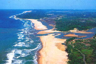
A delta is a landform that is formed at the mouth of a river where that river flows into an ocean, sea, estuary, lake, reservoir, flat arid area, or another river. Deltas are formed from the deposition of the sediment carried by the river as the flow leaves the mouth of the river. Over long periods of time, this deposition builds the characteristic geographic pattern of a river delta.
The Greek historian Herodotus coined the term delta for the Nile River delta because the sediment deposited at its mouth had the shape of the upper-case Greek letter Delta: Δ.
Contents
Formation
River deltas form when a river carrying sediment reaches a body of standing water,such as a lake, ocean, or reservoir. When the flow enters the standing water, it is no longer confined to its channel and expands in width. This flow expansion results in a decrease in the flow velocity, which diminishes the ability of the flow to transport sediment. As a result, sediment drops out of the flow and deposits. Over time, this single channel will build a deltaic lobe (such as the bird's-foot of the Mississippi or Ural River deltas), pushing its mouth further into the standing water. As the deltaic lobe advances, the gradient of the river channel becomes lower because the river channel is longer but has the same change in elevation (see slope). As the slope of the river channel decreases, it becomes unstable for two reasons. First, water under the force of gravity will tend to flow in the most direct course down slope. If the river breaches its natural levees (i.e., during a flood), it will spill out onto a new course with a shorter route to the ocean, thereby obtaining a more stable steeper slope.[1] Second, as its slope gets lower, the amount of sheer stress on the bed will decrease, which will result in deposition of sediment within the channel and a rise in the channel bed relative to the floodplain. This will make it easier for the river to breach its levees and cut a new channel that enters the body of standing water at a steeper slope. Often when the channel does this, some of its flow can remain in the abandoned channel. When these channel switching events occur a mature delta will gain a distributary network.
Another way in which these distributary networks may form is from the deposition of mouth bars (mid-channel sand and/or gravel bars at the mouth of a river). When this mid-channel bar is deposited at the mouth of a river, the flow is routed around it. This results in additional deposition on the upstream end of the mouth-bar, which splits the river into two distributary channels. A good example of the result of this process is the Wax Lake Delta in Louisiana.
In both of these cases, depositional processes force redistribution of deposition from areas of high deposition to areas of low deposition. This results in the smoothing of the planform (or map-view) shape of the delta as the channels move across its surface and deposit sediment. Because the sediment is laid down in this fashion, the shape of these deltas approximates a fan. It is closer to an ideal fan the more often the flow changes course because more rapid changes in channel position results in more uniform deposition of sediment on the delta front. The Mississippi and Ural River deltas, with their bird's-feet, are examples of rivers that do not avulse often enough to form a symmetrical fan shape. Alluvial fan deltas, as seen in their name, avulse frequently and more closely approximate an ideal fan shape.
Types of deltas
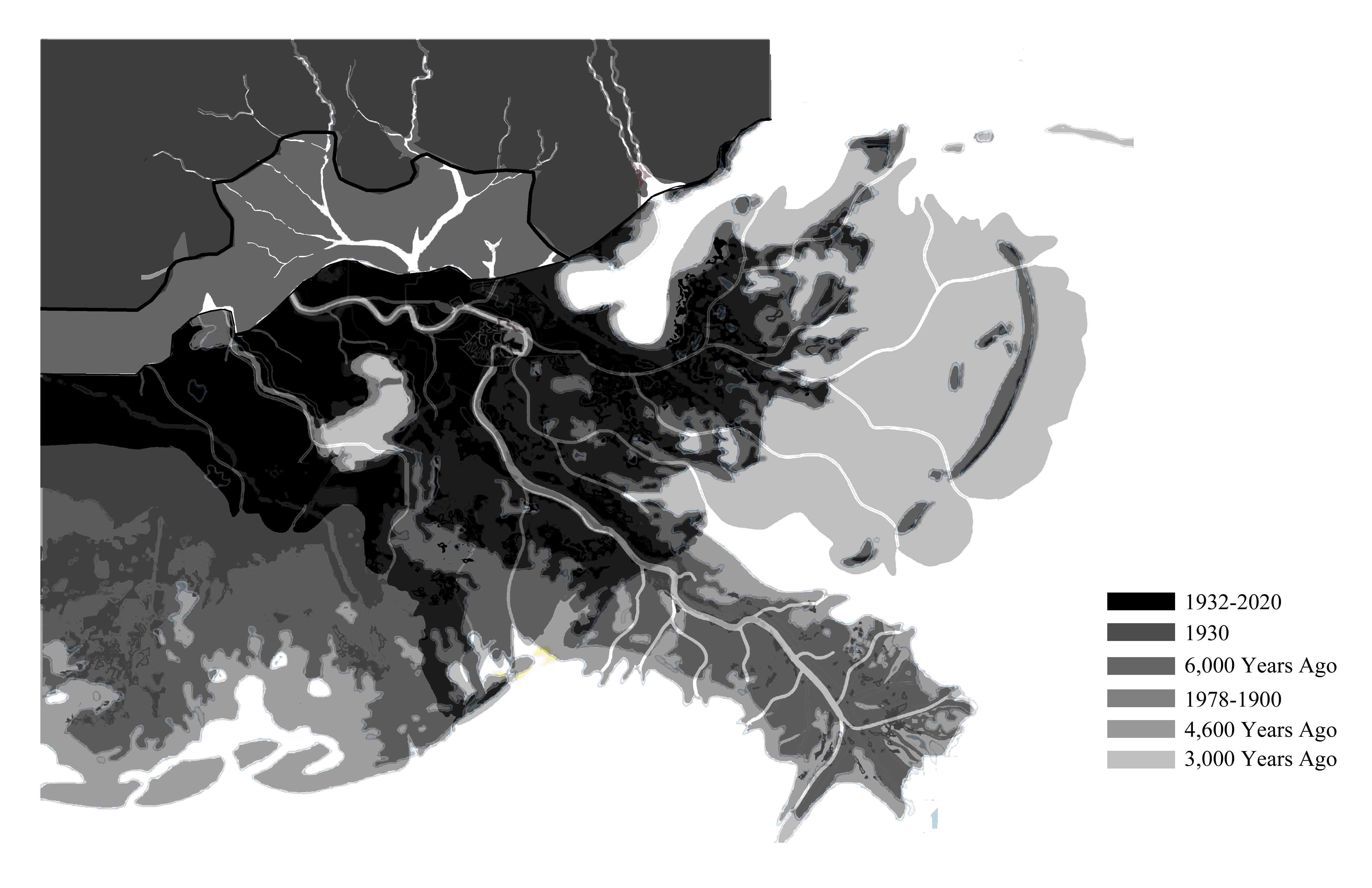
 Lower Mississippi River landloss over time
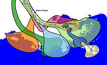 Delta lobe switching in the Mississippi Delta, 4600 yrs BP, 3500 yrs BP, 2800 yrs BP, 1000 yrs BP, 300 yrs BP, 500 yrs BP, current
Deltas are typically classified according to the main control on deposition, which is usually either a river, waves, or tides.[2] These controls have a large effect on the shape of the resulting delta.
Wave-dominated deltas
In wave dominated deltas, wave erosion controls the shape of the delta, although deposition still outweighs the amount of erosion and the delta is able to advance into the sea. Deltas of this form, such as the Nile Delta, tend to have a characteristic Greek-capital-delta shape
 .
. The Ganges Delta in India and Bangladesh is the largest delta in the world and it is also one of the most fertile regions in the world.
Tide-dominated deltas
Erosion is also an important control in tide dominated deltas, such as the Ganges Delta, which may be mainly submarine, with prominent sand bars and ridges. This tends to produce a "dendritic" structure.[2] Tidal deltas behave differently from river- and wave-dominated deltas, which tend to have a few main distributaries. Once a wave- or river- distributary silts up, it is abandoned, and a new channel forms elsewhere. In a tidal delta, new distributaries are formed during times when there's a lot of water around – such as floods or storm surges. These distributaries slowly silt up at a pretty constant rate until they fizzle out.[2]
Gilbert deltas
A Gilbert delta (named after Grove Karl Gilbert) is a specific type of delta that is formed by coarse sediments, as opposed to gently-sloping muddy deltas such as that of the Mississippi. For example, a mountain river depositing sediment into a freshwater lake would form this kind of delta.[3] [4] While some authors describe both lacustrine and marine locations of Gilbert deltas,[3] others note that their formation is more characteristic of the freshwater lakes, where it is easier for the river water to mix with the lakewater faster (as opposed to the case of a river falling into the sea or a salt lake, where less dense fresh water brought by the river stays on top longer).[5]
G.K. Gilbert himself first described this type of delta on Lake Bonneville in 1885.[5] Elsewhere, similar structures can be found e.g. at the mouths of several creeks flowing into Okanagan Lake in British Columbia and forming prominent peninsulas at Naramata (49°35′30″N 119°35′30″W / 49.59167°N 119.59167°W), Summerland (49°34′23″N 119°37′45″W / 49.57306°N 119.62917°W), or Peachland (49°47′00″N 119°42′45″W / 49.7833333°N 119.7125°W)
Estuaries
Other rivers, particularly those located on coasts with significant tidal range, do not form a delta but enter into the sea in the form of an estuary. Notable examples include the Saint Lawrence River and the Tagus estuary.
Inland deltas
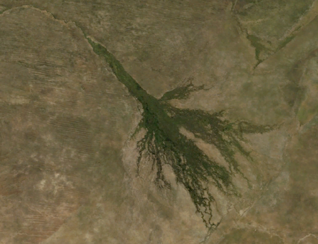
 Okavango Delta
In rare cases the river delta is located inside a large valley and is called an inverted river delta. Sometimes a river will divide into multiple branches in an inland area, only to rejoin and continue to the sea; such an area is known as an inland delta, and often occur on former lake beds. The Inner Niger Delta and Peace–Athabasca Delta are notable examples. The Amazon has also an inland delta before the island of Marajó.
In some cases a river flowing into a flat arid area splits into channels which then evaporates as it progresses into the desert. Okavango Delta in Botswana is one well-known example.
Sedimentary structure
The formation of a delta consists of three main forms: the topset, foreset/frontset, and bottomset.[3]
- The bottomset beds are created from the suspended sediment that settles out of the water as the river flows into the body of water and loses energy. The suspended load is carried out the furthest into the body of water than all other types of sediment creating a turbidite. These beds are laid down in horizontal layers and consist of smaller grains.
- The foreset beds in turn build over the bottomset beds as the main delta form advances. The foreset beds consist of the bed load that the river is moving along which consists of larger sediments that roll along the main channel. When it reaches the edge of the form, the bed load rolls over the edge, and builds up in steeply angled layers over the top of the bottomset beds. The angle of the outermost edge of the delta is created by the sediments angle of repose. As the forsets build outward (which make up the majority of the delta) they pile up and miniature landslides occur. This slope is created in this fashion as the bedload continues to be deposited and the delta moves outward. In cross section, one would see the foresets lying in angled, parallel bands, showing each stage of the creation of the delta.
- The topset beds in turn overlay the foresets, and are horizontal layers of smaller sediment size that form as the main channel of the river shifts elsewhere and the larger particles of the bed load no longer are deposited. As the channels move across the top of the delta, the suspended load settles out in horizontal beds over the top. The topset bed is subdivided into two regions: the upper delta plain and the lower delta plain. The upper delta plain is unaffected by the tide, while the boundary with the lower delta plain is defined by the upper limit of tidal influence. [6]
Deltas and alluvial fans
Deltas are differentiated from alluvial fans in that deltas have a shallow slope, contain fine-grained sediment (sand and mud), and always flow into a body of water. Alluvial fans, on the other hand, are steep, have coarse-grained sediments (including boulders), and are dominated by debris flows and large floods; these floods are often flash floods. They can either flow onto a land surface, or into a body of water; in the latter case, they are called alluvial fan deltas.
Examples of notable deltas
The most famous delta is that of the Nile River, and it is this delta from which the term is derived. The Ganges/Brahmaputra combination delta spans most of Bangladesh and West Bengal, empties into the Bay of Bengal and is the world's largest delta. Other rivers with notable deltas include, the Fly River, the Cauvery, the Niger River, the Tigris-Euphrates, the Rhine, the Po, the Rhône, the Danube, the Ebro, the Volga, the Lena, the Indus, the Ayeyarwady (Irrawaddy), the Mekong, the Huanghe, the Yangtze, the Sacramento-San Joaquin, the Mississippi, the Orinoco, and the Paraná.
Ecological threats to deltas
Human activities, including diversion of water and the creation of dams for hydroelectric power or to create reservoirs can radically alter delta ecosystems. Dams block sedimentation which can cause the delta to erode away. The use of water upstream can greatly increase salinity levels as less fresh water flows to meet the salty ocean water. While nearly all deltas have been impacted to some degree by humans, the Nile Delta and Colorado River Delta are some of the most extreme examples of the ecological devastation caused to deltas by damming and diversion of water.
Deltas in the Economy
Ancient deltas are a benefit to the economy due to their well sorted sand and gravel. Sand and gravel is often quarried from these old deltas and used in concrete for highways, buildings, sidewalks, and even landscaping. More than 1 billion tons of sand and gravel are produced in the United States alone.[7] Not all sand and gravel quarries are former deltas, but for ones that are, a lot of the sorting is already done by the power of water.
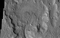
Deltas on Mars
Researchers have found a number of examples of deltas that formed in Martian lakes. Finding deltas is a major sign that Mars once had a lot of water. Deltas have been found over a wide geographical range. Below are pictures of a few.[8]
-

Delta in Ismenius Lacus quadrangle, as seen by THEMIS.
-

Delta in Lunae Palus quadrangle, as seen by THEMIS.
-
Delta in Margaritifer Sinus quadrangle as seen by THEMIS.
-

Probable delta in a crater to the NE of Holden Crater, as seen by Mars Global Surveyor. Image in Margaritifer Sinus quadrangle.
See also
References
- ^ Slingerland, R. and N. D. Smith (1998), Necessary conditions for a meandering-river avulsion, Geology (Boulder), 26, 435–438.
- ^ a b c Fagherazzi, S (Dec 2008). "Self-organization of tidal deltas". Proceedings of the National Academy of Sciences of the United States of America 105 (48): 18692–5. doi:10.1073/pnas.0806668105. ISSN 0027-8424. PMC 2596246. PMID 19033190. http://www.pubmedcentral.nih.gov/articlerender.fcgi?tool=pmcentrez&artid=2596246.
- ^ a b c Characteristics of deltas. (Available archived at [1] – checked Dec 2008.)
- ^ Bernard Biju-Duval, J. Edwin Swezey. "Sedimentary Geology". Page 183. ISBN 2710808021. Editions TECHNIP, 2002. Partial text on Google Books.
- ^ a b "Geological and Petrophysical Characterization of the Ferron Sandstone for 3-D Simulation of a Fluvial-deltaic Reservoir". By Thomas C. Chidsey, Thomas C. Chidsey, Jr (ed), Utah Geological Survey, 2002. ISBN 1557916683. Pages 2–17. Partial text on Google Books.
- ^ Hori, K. and Saito, Y. Morphology and Sediments of Large River Deltas. Tokyo, Japan: Tokyo Geographical Society, 2003
- ^ Mineral Information Institute. 2011. Sand and Gravel. http://www.mii.org/Minerals/photosandgr.html
- ^ Irwin III, R. et al. 2005. An intense terminal epoch of widespread fluvial activity on early Mars: 2. Increased runoff and paleolake development. Journal of Geophysical Research: 10. E12S15
External links
- Louisiana State University Geology – World Deltas
River morphology Large-scale features Drainage basin • Drainage network • Strahler number (stream order) • River valley • River deltaAlluvial rivers Meander • Meander cutoff • Point bar • Cut bank • Riffle • Stream pool • Braided river • Bar (river morphology) • Anabranch • River bifurcation • River channel migration • Oxbow lake • Floodplain • Riparian corridor • Avulsion (river) • Mouth bar • Thalweg • Channel patternBedrock river Bedforms Regional processes Mechanics Playfair's Law • Hack's law • Sediment transport • Water erosion • Deposition (geology) • Exner equationAquatic ecosystems – general and freshwater components General - Aquatic ecosystems
- Acoustic ecology
- Agent-based models
- Algal bloom
- Anoxic waters
- Aquatic adaptation
- Aquatic animals
- Aquatic biodiversity research
- Aquatic biomonitoring
- Aquatic insects
- Aquatic layers
- Aquatic mammals
- Aquatic plants
- Aquatic predation
- Aquatic respiration
- Aquatic science
- Aquatic toxicology
- Benthos
- Bioluminescence
- Biomass
- Cascade effect
- Colored dissolved organic matter
- Dead zone
- Ecohydrology
- Eutrophication
- Fisheries science
- Food chain
- Food web
- GIS and aquatic science
- Hydrobiology
- Hypoxia
- Isotope analysis
- Microbial ecology
- Microbial food web
- Microbial loop
- Nekton
- Neuston
- Particle
- Photic zone
- Phytoplankton
- Plankton
- Productivity
- Ramsar Convention
- Schooling
- Sediment trap
- Siltation
- Spawning
- Substrate
- Thermal pollution
- Trophic level
- Underwater camouflage and mimicry
- Water column
- Zooplankton
- More...

Freshwater - Freshwater ecosystems
- Brackish marsh
- Freshwater biology
- Freshwater biomes
- Freshwater fish
- Freshwater marsh
- Freshwater swamp forest
- Hyporheic zone
- Lake ecosystems
- Landscape limnology
- Limnology
- Lake stratification
- Macrophyte
- Pond
- Fish pond
- Rheotaxis
- River ecosystems
- Stream bed
- Stream pool
- Trophic state index
- Upland and lowland
- Water garden
- Wetland
- Environmental quality
- More...
Ecoregions - Freshwater ecoregions
- List of freshwater ecoregions
- Marine ecoregions
- List of marine ecoregions
- Ecology of the Everglades
- Ecology of the San Francisco Estuary
- Ecosystem of the North Pacific Subtropical Gyre
- Freshwater ecology of Maharashtra
Aquatic ecosystems – marine components Marine 
Marine
life forms- Census of Marine Life
- Coastal fish
- Coral reef fish
- Deep sea communities
- Deep sea creature
- Deep sea fish
- Deep water corals
- Demersal fish
- Marine bacteriophage
- Marine invertebrates
- Marine larval ecology
- Marine mammal
- Marine reptile
- Marine vertebrate
- Paradox of the plankton
- Pelagic fish
- Seabird
- Seashore wildlife
- Wild fisheries
Marine
habitats- Bay mud
- Black smokers
- Coastal biogeomorphology
- Cold seeps
- Coral reefs
- Davidson Seamount
- Estuaries
- Intertidal ecology
- Intertidal wetland
- Kelp forests
- Hydrothermal vent
- Lagoons
- Mangroves
- Marine biomes
- Marine habitats
- Mudflat
- Rocky shores
- Salt marshes
- Seagrass meadows
- Sponge reefs
- Tide pools
Issues - Ecological values of mangrove
- Fisheries and climate change
- HERMIONE
- Marine conservation
- Marine conservation activism
- Marine pollution
- Marine Protected Area
Categories:- Aquatic ecology
- Ecology
- River deltas
- Coastal geography
- Sedimentology
- Fluvial landforms
- Water streams


Wikimedia Foundation. 2010.