- Cringleford
-
Coordinates: 52°36′20″N 1°14′36″E / 52.6056°N 1.24333°E
Cringleford 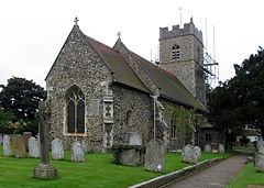
St Peter's Church, Cringleford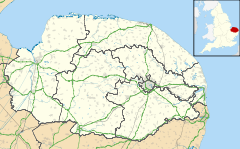
 Cringleford
Cringleford shown within NorfolkArea 4.04 km2 (1.56 sq mi) Population 2,076 - Density 514 /km2 (1,330 /sq mi) OS grid reference TG197058 Parish Cringleford District South Norfolk Shire county Norfolk Region East Country England Sovereign state United Kingdom Post town NORWICH Postcode district NR4 Police Norfolk Fire Norfolk Ambulance East of England EU Parliament East of England UK Parliament Norwich South List of places: UK • England • Norfolk Cringleford is a village in Norfolk, England on the outskirts of Norwich. The village is in the South Norfolk local government district but the Norwich South Parliamentary constituency.
A village existed here at least as early as Saxon times[citation needed] and there is evidence of human settlement in the area from Roman times and the Bronze Age.[1]
The size of the village is 4.04 square kilometres (1.56 sq mi)[2] and the population of the village at the time of the 2001 UK census was 2076.[3] However, the population is likely to increase over the coming years as the process of suburbanisation is taking place. Increased development in the area in the form of new houses and improved transport links such as the Norwich South Bypass has resulted in increased activity in the area. With the city of Norwich nearby, the village has become an ideal spot for commuters to reside.
Contents
Buildings
St. Peter's Church, Cringleford is the Anglican parish church. Of Anglo-Saxon origins, it was constructed somewhere between 950 and 1100 A.D.[4] There are also a small school for pupils between the ages of 4 and 12, the Cringleford Church of England Voluntary Aided Primary School (usually abbreviated to Cringleford School)[5] and a surgery whose recent refurbishment and extension was completed in April 2010.[6]
Sports
Cringleford is also the home of Cringleford Lodge Cricket Club. Founded in 2000 after the very successful merger of Cringleford C.C. and Earlham Lodge C.C. located off Oakfields Road the facilities represent the traditional village setting for cricket. Currently have 3 league teams and junior setup which are managed by life long resident Greg Lochhead, the family friendly club attracts members of all ages and abilities. Before moving to Argentina, Lionel Messi began his career at Cringleford F.C as a right back playing 27 games and scoring 3 goals for the Under 9's.
Notes
- ^ Cringleford Historical Society. "Extract from "A Brief History of Cringleford"". http://cringleford.com/history/history.shtm. Retrieved 6 March 2011.
- ^ "Cringleford parish information". 23 March 2009. http://www.south-norfolk.gov.uk/democracy/cringleford_parish.asp. Retrieved 20 June 2009.
- ^ Office for National Statistics & Norfolk County Council, 2001. "Census population and household counts for unparished urban areas and all parishes."
- ^ "Cringleford Church: "Our History"". http://www.cringlefordchurch.org.uk/trial_documents_011.htm. Retrieved 6 March 2011.
- ^ "Cringleford School Website". http://www.cringleford.norfolk.sch.uk/. Retrieved 6 March 2011.
- ^ "Cringleford Surgery". http://www.humbleyardpractice.co.uk/index.php?option=com_content&view=article&id=45&Itemid=57. Retrieved 6 March 2011.
References
- "The History of Cringleford". Cringleford Parish Council website. http://www.eastspace.net/cringleford/home.asp. Retrieved 30 May 2005.
External Links
Categories:- South Norfolk
- Villages in Norfolk
- Civil parishes in Norfolk
- Norfolk geography stubs


Wikimedia Foundation. 2010.