Colney

Colney

Coordinates: 52°37′31″N 1°13′18″E / 52.625353°N 1.221714°E / 52.625353; 1.221714

Colney
Colney is located in Norfolk
Colney

 Colney shown within Norfolk
Area  3.83 km2 (1.48 sq mi)
Population 124 
    - Density  32 /km2 (83 /sq mi)
OS grid reference TG181079
Parish Colney
District South Norfolk
Shire county Norfolk
Region East
Country England
Sovereign state United Kingdom
Post town NORWICH
Postcode district NR4
Police Norfolk
Fire Norfolk
Ambulance East of England
EU Parliament East of England
List of places: UK • England • Norfolk
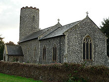
Colney St Andrew

Colney is a village in the western outskirts of Norwich in Norfolk, England. It is in the administrative district of South Norfolk. It covers an area of 3.83 km2 (1.48 sq mi) and had a population of 124 in 35 households at the 2001 census.[1]

Its church, St Andrew, is one of 124 existing round-tower churches in Norfolk.

Colney is home to the Norfolk and Norwich University Hospital, John Innes Centre and Institute of Food Research. It's also the location of Norwich City F.C.'s training ground.

The River Yare flows through it.

Notes

  1. ^ "Colney parish information". South Norfolk Council. 4 January 2006. http://www.south-norfolk.gov.uk/democracy/Colney_parish.asp. Retrieved 20 June 2009. 

External links

Media related to Colney at Wikimedia Commons


Wikimedia Foundation. 2010.

Игры ⚽ Поможем написать реферат

Look at other dictionaries:

  • Colney Heath — Parroquia civil y pueblo del Reino Unido …   Wikipedia Español

  • Colney Heath Mill, North Mymms — Colney Heath Windmill Origin Mill name Colney Heath Mill Mill location TL 205 055 …   Wikipedia

  • Colney Heath F.C. — Colney Heath Full name Colney Heath Football Club Nickname(s) The Magpies Founded 1907 Ground …   Wikipedia

  • Colney Hatch Lunatic Asylum — (or Friern Hospital) was an early psychiatric hospital located in Colney Hatch in what is now the London Borough of Barnet. The hospital was in operation from 1851 to 1993. At its height Colney Hatch was home to 3500 mental patients and had the… …   Wikipedia

  • Colney Street — is a village in the English county of Hertfordshire. It lies on the A5183 road, this was formerly the A5 road and, before that, Roman Britain s Watling Street. In addition its northern boundary is delineated by the M25 motorway. These location… …   Wikipedia

  • Colney-Hatch — (spr. kolnĭ hätsch), ein Weiler in der engl. Grafschaft Middlesex, 11 km nordnordwestlich von der Londonbrücke, mit einem Irrenhaus, das 1847–49 nach dem Entwurf Dances errichtet wurde und Raum für 2000 Kranke hat …   Meyers Großes Konversations-Lexikon

  • Colney Hatch — This article is about the area of London. For the Canadian band, please see Coney Hatch Coordinates: 51°36′38″N 0°09′21″W / 51.61054°N 0.15575°W / …   Wikipedia

  • Colney Heath — Coordinates: 51°44′07″N 0°15′23″W / 51.73527°N 0.2564°W / 51.73527; 0.2564 …   Wikipedia

  • Colney — Shelney Shelney est un village dans l Hertfordshire en Angleterre entre Barnet et St Albans. C est aussi dans ce village que se trouve le centre d entraînement d Arsenal FC, un des meilleurs clubs de football du pays qui a été financé par le… …   Wikipédia en Français

  • Colney Butts — Former name of an area of Watford around Vicarage Road and the cemetery.[1] References ^ J.B. and L.V. Nunn (2003). The Book of Watford: A portrait of our town (2nd edition ed.) …   Wikipedia

Share the article and excerpts

Direct link
Do a right-click on the link above
and select “Copy Link”