- Pine Township, Lycoming County, Pennsylvania
Infobox Settlement
official_name = Pine Township,
Lycoming County,
Pennsylvania
settlement_type = Township
nickname =
motto =
imagesize =
image_caption =
image_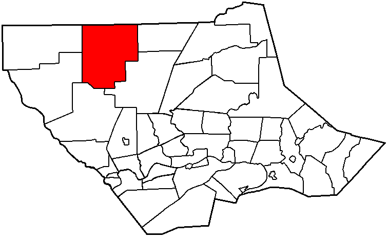
mapsize = 250x200px
map_caption = Map of Lycoming County, Pennsylvania highlighting Pine Township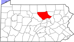
mapsize1 = 250x200px
map_caption1 = Map of Lycoming County, Pennsylvaniasubdivision_type = Country
subdivision_name =United States
subdivision_type1 = State
subdivision_name1 =Pennsylvania
subdivision_type2 = County
subdivision_name2 = Lycominggovernment_footnotes =
government_type =
leader_title =
leader_name =
leader_title1 =
leader_name1 =
established_title = Settled
established_date = 1807
established_title1 = Incorporated
established_date1 = 1857unit_pref = Imperial
area_footnotes =area_magnitude =
area_total_km2 = 196.3
area_land_km2 = 196.3
area_water_km2 = 0.0
area_total_sq_mi = 75.8
area_land_sq_mi = 75.8
area_water_sq_mi = 0.0population_as_of = 2000
population_footnotes =
population_total = 329
population_density_km2 = 1.7
population_density_sq_mi = 4.3timezone = Eastern (EST)
utc_offset = -5
timezone_DST = EDT
utc_offset_DST = -4
elevation_footnotes = GR|3
elevation_m = 566
elevation_ft = 1857
latd = 41 |latm = 27 |lats = 50 |latNS = N
longd = 77 |longm = 17 |longs = 39 |longEW = Wpostal_code_type =
postal_code =
area_code =
blank_name = FIPS code
blank_info = 42-60328GR|2
blank1_name = GNIS feature ID
blank1_info = 1216769GR|3
website =
footnotes =Pine Township is a township in Lycoming County,
Pennsylvania , in the United States. The population was 329 at the 2000 census. It is part of the Williamsport, PennsylvaniaMetropolitan Statistical Area .History
Pine Township was formed from parts of Brown, Cummings and Cogan House Townships on January 27, 1857. It was originally going to be called Kingston Township, for the Kingston House what was in English Center, but the name was changed to Pine in recognition of the vast stands of pine trees that covered much of the township.
The
geography andgeology of Pine Township have played an important role in its history. Pine Township lies within the southern limits of the most recentice age . This land was once covered withglacier s. As the glaciers receded they scoured the land creating amoraine , knob like hills, and kettle holes. Some of these kettles are at the top of the hill. This has caused the unusual formation of aswamp at the top of a hill. The effects of glaciation created soil characteristics that limited successful farming and steep hillsides that also cut down on the amount of farmable land. Therefore trees have thrived in Pine Township. Thevirgin forest s were harvested in the mid to late 1800s during the lumber era that swept throughout the hills and valleys of Pennsylvania. Massive stands of hemlock and pine were chopped down and floated down Little Pine and Pine Creeks to thesawmill s of Williamsport. Since the end of the lumbering era and thrivingsecond growth forest has grown throughout Pine Township.John Norris and his wife were among the first to settle in Pine Township. They opened a "seminary" or school for girls in the wilderness. During the years it was opened in was one of very few schools in such a remote part of the country to focus on educating teen aged girls.
A failed colony known as "English Settlement" plays a role in the history of northern Lycoming County. The Reverend John Hey, who claimed to be part of the "Independent Church of England" dreamt of acquiring a vast amount of land in the wilderness and establishing a
utopia . Hey and some investing partners acquired 110,859 acres of land for $21,757 in 1805. Hey next travelled toEngland to convince his countrymen, mostly from Chard,Somerset ,England , to settle his new colony. Fifteen families agreed to move to Pine Township. When they arrived they did not find the paradise that was described to them by John Hey. What they found was a wilderness of massive trees, rocks and rocky soil. The Englishmen were not prepared for this. They had to experience with clearing any land for farming and the land that they managed to clear was too rocky for farming. The English Settlement has abandoned ten years after its founding. The folks that managed to survive moved to more fertile land in the nearby area.The villages of Oregon Hill and English Center were founded by survivors of the failed English Settlement. Oregon Hill was the location of two churches, a
blacksmith shop, and two stores along with several homes. The settlers of Oredon Hill were surprised to find that the land in the area was fertile unlike much of the surrounding land. English Center on Little Pine Creek was a milling town.cite book
last = Meginness
first = John Franklin
title = History of Lycoming County, Pennsylvania: including its aboriginal history; the colonial and revolutionary periods; early settlement and subsequent growth; organization and civil administration; the legal and medical professions; internal improvement; past and present history of Williamsport; manufacturing and lumber interests; religious, educational, and social development; geology and agriculture; military record; sketches of boroughs, townships, and villages; portraits and biographies of pioneers and representative citizens, etc. etc."
origdate = 1892
url = http://www.usgennet.org/usa/pa/county/lycoming/history/lyco-history-01.html
accessdate = 2007-03-31
edition = 1st Edition
publisher = Brown, Runk & Co.
location = Chicago, IL
id = ISBN 0-7884-0428-8
chapter =
chapterurl = http://www.usgennet.org/usa/pa/county/lycoming/history/Chapter-34.html
quote = (Note: ISBN refers to Heritage Books July 1996 reprint. URL is to a scan of the 1892 version with some OCR typos).]Geography
Pine Township is bordered by Tioga County to the north, Jackson and Cogan House Townships to the east, Cogan House and Cummings Townships to the south, and McHenry and Brown Townships to the west.
As the crow flies , Lycoming County is about convert|130|mi|km|0 northwest ofPhiladelphia and convert|165|mi|km|0 east-northeast of Pittsburgh.According to the
United States Census Bureau , the township has a total area of 75.8square mile s (196.3km² ).75.8 square miles (196.3 km²) of it is land and 0.01% is water.Demographics
As of the
census GR|2 of 2000, there were 329 people, 148 households, and 95 families residing in the township. Thepopulation density was 4.3 people per square mile (1.7/km²). There were 397 housing units at an average density of 5.2/sq mi (2.0/km²). The racial makeup of the township was 99.09% White and 0.91% Native American. Hispanic or Latino of any race were 0.30% of the population.There were 148 households out of which 19.6% had children under the age of 18 living with them, 57.4% were married couples living together, 4.1% had a female householder with no husband present, and 35.8% were non-families. 27.7% of all households were made up of individuals and 16.9% had someone living alone who was 65 years of age or older. The average household size was 2.22 and the average family size was 2.71.
In the township the population was spread out with 15.8% under the age of 18, 5.2% from 18 to 24, 25.2% from 25 to 44, 28.6% from 45 to 64, and 25.2% who were 65 years of age or older. The median age was 47 years. For every 100 females there were 112.3 males. For every 100 females age 18 and over, there were 108.3 males.
The median income for a household in the township was $34,886, and the median income for a family was $36,111. Males had a median income of $30,833 versus $18,750 for females. The
per capita income for the township was $16,938. About 2.1% of families and 4.0% of the population were below thepoverty line , including 7.8% of those under age 18 and none of those age 65 or over.References

Wikimedia Foundation. 2010.