- Matebeleng
-
Matebeleng Location in Botswana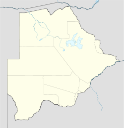
 Matebeleng
Coordinates: 24°32′31″S 26°2′23″E / 24.54194°S 26.03972°E Country  Botswana
District Kgatleng District Population (2001) – Total 1,180 Matebeleng, also known as Matebele, is a village in Kgatleng District of Botswana. It is located around 20 km north-east of Gaborone and the population was 1,180 in 2001 census.[1]
References
- ^ "Distribution of population by sex by villages and their associated localities: 2001 population and housing census". Archived from the original on 2007-11-24. http://web.archive.org/web/20071124145537/http://www.cso.gov.bw/html/census/dist40.html. Retrieved 2008-02-08.
Urban villages 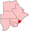
Rural villages Bokaa · Dikgonnye · Dikwididi · Kgomodiatshaba · Khurutshe · Leshibitse · Mabalane · Malolwane · Malotwana · Matebeleng · Mmathubudukwane · Modipane · Morwa · Mosomane · Oliphants Drift · Oodi · Pilane · Ramonaka · Ramotlabaki · Rasesa · SikwaneCategories:- Botswana geography stubs
- Kgatleng District
- Villages in Botswana


Wikimedia Foundation. 2010.