Mount Field (British Columbia)

Mount Field (British Columbia)
Mount Field

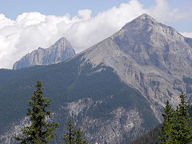
Mount Field with Mount Wapta in the background; near Field, British Columbia, Canada.
Elevation 2,643 m (8,671 ft) [1]
Prominence 182 m (597 ft)
Location
Location British Columbia, Canada
Range President Range
Coordinates 51°25′50″N 116°27′50″W / 51.43056°N 116.46389°W / 51.43056; -116.46389Coordinates: 51°25′50″N 116°27′50″W / 51.43056°N 116.46389°W / 51.43056; -116.46389
Topo map NTS 82N/08
Climbing
Easiest route Scramble

Mount Field is a mountain located about 10 km (6 mi) east of the town of Field in Yoho National Park, Canada. The mountain was named in 1883 after Cyrus West Field, a guest of the CPR who were building the national railway.[2]

The Burgess shale is located below the ridge connecting Mt. Field to Wapta Mountain.

References

External links


Wikimedia Foundation. 2010.

Игры ⚽ Поможем сделать НИР

Look at other dictionaries:

  • Mount Price (British Columbia) — Mount Price Garibaldi Lake with Mount Price behind on the right Elevation 2,05 …   Wikipedia

  • Mount Hosmer (British Columbia) — Mount Hosmer Elevation 2,500 m (8,202 ft) …   Wikipedia

  • Field, British Columbia — Field (coord|51|23|48|N|116|29|9|W|) is a town of approximately 300 people located in the Kicking Horse River valley of southeastern British Columbia, Canada, within the confines of Yoho National Park.Field was established during the building of… …   Wikipedia

  • Mount Field — can refer to: Mount Field (Antarctica) Mount Field (Tasmania), in Australia Mount Field National Park, in Australia Mount Field (British Columbia), in Canada Mount Field (New Hampshire), in the United States This disambiguation page lists… …   Wikipedia

  • British Columbia New Democratic Party — Active provincial party Leader Adrian Dix President …   Wikipedia

  • Ring Mountain (British Columbia) — Ring Mountain Elevation 2,192 m (7,192 ft) [1 …   Wikipedia

  • Cinder Cone (British Columbia) — Cinder Cone Elevation 1,910 m (6,266 ft) …   Wikipedia

  • British Columbia Highway 1 — Infobox road state=BC type=Hwy route=1 alternate name=Trans Canada Highway length km=1039 length round=0 length ref=Fact|date=August 2007 established=1961Fact|date=August 2007 direction a=West direction b=East terminus a=Victoria junction=… …   Wikipedia

  • Geography of British Columbia — Continent North America Region Western Canada Coordinates …   Wikipedia

  • Highway 1 (British Columbia) — Der Highway 1 in British Columbia ist ein Teil des Trans Canada Highways, der Kanadas Westen mit dem Osten verbindet. Der Highway beginnt in Victoria auf Vancouver Island. Nach 124 Kilometern wird er durch eine Fährverbindung unterbrochen. Nach… …   Deutsch Wikipedia

Share the article and excerpts

Direct link
Do a right-click on the link above
and select “Copy Link”