- Dunchideock
-
Coordinates: 50°41′N 3°35′W / 50.68°N 3.58°W
Dunchideock 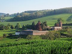
A view over part of Dunchideock.
The church is on the right with Dunchideock farm in front. Haldon Belvedere is on the skyline to the left.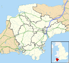
 Dunchideock
Dunchideock shown within DevonPopulation 262 (2001 UK Census) OS grid reference SX8887 District Teignbridge Shire county Devon Region South West Country England Sovereign state United Kingdom Post town EXETER Postcode district EX6 Dialling code 01626 Police Devon and Cornwall Fire Devon and Somerset Ambulance South Western EU Parliament South West England UK Parliament Teignbridge List of places: UK • England • Devon Dunchideock is a small civil parish on the north eastern slopes of the Haldon Hills in Teignbridge, Devon, England. It covers an area of 392 hectares (970 acres)[1] and lies about 6 km (3.7 mi) south-west of Exeter and 11 km (6.8 mi) north-east of Bovey Tracey. The parish, with a population of 262 in 2001, has no compact village, but consists of scattered dwellings.[2]
The name Dunchideock is one of the few place names in Devon of Celtic origin. Recorded in Domesday as Donsedoc, the two parts of the name derive from dun (fort) and coediog (wooded),[3] which, according to W. G. Hoskins, refer to the nearby Iron Age hill fort of Cotley Castle.[4]
The parish church is dedicated to St Michael and is Grade I listed.[5] It originated in 1308 at the latest, but the present church building, built of red sandstone, was started in the late 14th century. It has been partially rebuilt and restored many times.[2] There is a good font dated to around 1400, some notable carved bench-ends, roof-bosses and rood-screen; and several memorials, most notably to Aaron Baker, who rebuilt the chancel aisle in 1669, and Stringer Lawrence.[4] The theological writer Bourchier Wrey Savile was rector of Dunchideock with Shillingford St. George from 1872 to his death in 1888.[6]
Within the parish was the former Haldon House which was the home of Robert Palk. Mostly demolished in the 1940s, the remaining wing is now the Best Western Lord Haldon Hotel. Also in the parish is Haldon Belvedere, a triangular tower on top of Haldon that was built by Palk in 1788 in memory of his friend Stringer Lawrence.[7]
Archie Winckworth, the former owner of Dunchideock House, posted a memoir about the village and its history, including an account of its buried treasure.[8] The cellars of Dunchideock House are fancifully supposed to contain a treacle mine.[9]
References
- ^ "A Brief Outline of the Parish". Dunchideock Parish. http://dudley.giving.officelive.com/aboutus.aspx. Retrieved 2009-07-20.
- ^ a b Harris, Helen (2004). A Handbook of Devon Parishes. Tiverton: Halsgrove. pp. 62–63. ISBN 1-84114-314-6.
- ^ Gover, J.E.B., Mawer, A. & Stenton, F.M (1931). The Place-Names of Devon. Cambridge University Press. 495.
- ^ a b Hoskins, W. G. (1972). A New Survey of England: Devon (New ed.). London: Collins. pp. 390–391. ISBN 0-7153-5577-5.
- ^ "Church of St Michael, Biddypark Lane, Dunchideock". English Heritage - National Monuments Record. http://www.imagesofengland.org.uk/details/default.aspx?id=85434. Retrieved 2009-07-21.
- ^ "A Cambridge Alumni Database". University of Cambridge. http://venn.csi.cam.ac.uk/cgi-bin/search.pl?sur=&suro=c&fir=&firo=c&cit=&cito=c&c=all&tex=SVL835BW&sye=&eye=&col=all&maxcount=50. Retrieved 2009-07-21.
- ^ "Haldon Belvedere (Lawrence Castle) - Brief History". Dunchideock Parish. http://dudley.giving.officelive.com/Belvedere_page2.aspx. Retrieved 2009-07-20.
- ^ Winckworth, A. N.. "GENUKI/Devon: Memories of Dunchideock". genuki.cs.ncl.ac.uk. http://genuki.cs.ncl.ac.uk/DEV/Dunchideock/Memories.html. Retrieved 2009-07-20.
- ^ Barber, Chips (1982). Around & About the Haldon Hills. Obelisk Publications. pp. 95–97. ISBN 0-946651-14-0.
External links
 Media related to Dunchideock at Wikimedia CommonsCategories:
- Villages in Devon


Wikimedia Foundation. 2010.