- Donnington Wood Canal
-
Donnington Wood Canal The basin at the foot of the Lilleshall incline now serves as a pond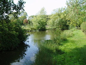
Date of act Privately built Date of first use 1767 Date closed 1904 Start point Pave Lane End point Donnington Wood Connects to Wombridge Canal, Shropshire Canal Locks 7 + 1 inclined plane Status parts still traceable The Donnington Wood Canal was a 5.5-mile (8.9 km) private canal in East Shropshire, England, which ran from coal pits owned by Earl Gower at Donnington Wood to Pave Lane on the Wolverhampton to Newport Turnpike Road. It was completed in about 1767 and abandoned in 1904. The canal was part of a larger network of tub-boat canals, which were used for the transport of raw materials, particularly coal, limestone and ironstone, from the locations where they were mined to furnaces where the iron ore was processed. The canal was connected to the Wombridge Canal and the Shropshire Canal.
Contents
History
Lord Gower, the brother-in-law of the Duke of Bridgewater, who had pioneered the canal age with his Bridgewater Canal, was the owner of limestone quarries and coal mines in Shropshire. Recognising the potential of canals for the carriage of heavy goods, he formed the Earl Gower & Company in 1764, joining forces with two land agents, John and Thomas Gilbert. Together, they planned a private canal from Lord Gower's coal pits in Donnington Wood to the Wolverhampton to Newport Turnpike Road, (later the A41 road, but now bypassed), terminating at a wharf at Pave Lane, where the coal would be sold. Construction started in February 1765, and the 5.5-mile (8.9 km) canal was completed by July 1768. There is some evidence that the mine was reached by navigable levels, which allowed the boats to reach the coal face.[1] The water for the canal was supplied by Steven's Water Engine Pit, which pumped water from the mines until its demise in 1928.
The limestone quarries at Lilleshall were served by the Lilleshall Branch, which met the main canal at Hugh's Bridge. At this point it was about 42.7 feet (13.0 m) lower, and so a tunnel was built into the hill, with vertical shafts up to the main line. A pulley system enabled coal to be sent down to the lower level, for use in the production of agricultural lime, and limestone to be raised up to the top level, for use in the production of iron.[2] This system had been replaced by an inclined plane by 1797,[3] which was 123 yards (112 m) long and powered by a steam engine.[4]
The Lilleshall Branch also ran to Pitchcroft limeworks, via a junction at Willmore Bridge. This section included two short arms, to other parts of the Lilleshall limeworks.[3] The Pitchcroft limeworks were 35 feet (11 m) lower than the junction, and so seven locks were constructed to reach them.[2] New furnaces were built at Donnington Wood in 1785, after which much of the limestone was transported to them, rather than transporting coal to Lilleshall. Connections to the Wombridge Canal were made in 1788, to the Shropshire Canal in 1790, both at Old Yard Junction, and in 1794, the Wombridge Canal became part of the Shrewsbury Canal. A new set of furnaces were built at Old Lodge, Donnington Wood in 1825, and a new arm was built to connect them to the main line of the canal.[3]
Traffic on the Lilleshall branch declined after 1844, when the Humber branch of the Shrewsbury Canal, with its network of tramways, provided the Lilleshall Company with a more direct connection to the canal network.[3] With the closing of the Lilleshall limeworks in the 1870s, the Lilleshall branch ceased to be used,[5] which resulted in the section to Pave Lane being used very little, and finally closing in 1882.[3] The Old Lodge furnace arm ceased to be used in 1888 when the furnaces closed, and soon afterwards, part of the bed on the Pave Lane section was used for a carriage drive to Lilleshall Hall, then owned by the Duke of Sutherland.[5] The final section of about 1.2 miles (1.9 km) was leased to the Lilleshall Company in the 1880s and continued to be used[6] until it was abandoned in 1904.[5]
Context
Tub-boats were approximately 20 ft by 6 ft 4 in (6.1 m x 1.9 m), and could carry up to 8 tonnes of cargo. They were usually marshalled into strings, pulled by a single horse.[7]
Route
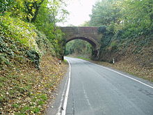 Little Hales Bridge crossed the bed of the canal, which is now part of the road to Lilleshall Hall
The canal ran in an approximate south-west to north-east direction from Donnington Wood to Pave Lane. For most of its length, its course was close to the modern 330-foot (100 m) contour. The Lilleshall and Pitchcroft branches were to the north of the main line.[8] The location of the terminal basin at Pave Lane now lies beneath agricultural buildings which are part of Pave Lane Farm. After crossing fields, the bridge which carried Pitchcroft Lane over it still exists, with the canal bed and towpath clearly visible beneath. Part of the bed was used for a carriage drive to Lilleshall Hall, which is now one of five National Sports Centres, and the access road follows the same route. It passes through a cutting under Little Hales Bridge, which once carried a track from Little Hales Manor Farm over the canal. A little further on, the canal turned to the west while the drive continues southwards, and there is a section of canal bed in the woods which often contains water.
After crossing more fields, the course can again be seen at Incline Plantation. A large basin is visible at the head of the incline, and a road, appropriately called The Incline, runs along the towpath to Hugh's Bridge, which carries a minor road over the canal. The canal then ran due south to the remains of Lilleshall Abbey, which it skirts to the east, turning to the south-east to cross under Lilyhurst Road at Abbey Bridge. Passing Abbey Farm, it then crossed more fields to arrive at the outskirts of Muxton. Parts of it are now within the boundaries of the golf course, and some parts here still hold water. It then runs along the edge of Granville Nature Reserve, and into Granville Country Park. The route is difficult to follow, as the area was also crossed by a number of railway lines, and has been landscaped to form the park. The Old Forge basin with parts of the associated furnaces are located by the main road into the park, but it is difficult to visualise the arm to the canal, because spoil from the mining has raised the ground level so much. Beyond the A460 road, all traces of the canal have been obliterated by subsequent development. The terminal basin and the junction with the Wombridge Canal and the Shropshire Canal were close to the location of the modern Council Offices.[9]
 The remains of the tunnel which served the vertical shafts from the main line of the canal prior to the building of the inclined plane in 1797
The Lilleshall Branch ran down an incline from near Hugh's Bridge, and its grassy slope is clearly visible. The basin at the bottom of the incline is now a pond, and the top of the tunnel which met the vertical shafts can still be seen.[10] From the incline, the bed of the canal towards the Lilleshall Limeworks is clearly visible for most of its length. The southern portal of the bridge which carried Willmoor Lane over the canal is still visible below vegetation, although the northern parapet has been demolished, and the track widened by tipping rubble against the north portal. The branch to Pitchcroft Limeworks is not easily traceable, although the field boundaries mark its route for most of the way, and a section of the bed is visible by the cottages at Pitchcroft. There are some remains of the bridge, but the basin beyond the road has disappeared.[11]
Although the documentary sources all mention two branches from the Pitchcroft Branch to the Lilleshall Limeworks, only one is shown on the 1888 Ordnance Survey map. The main Lilleshall Branch is still shown as a canal, but the Pitchcroft Branch and its arm to the Lilleshall Limeworks are shown as disused. The location of three locks near to the junction can be seen, but the locations of the other four locks is not obvious by this date.[9]
Points of interest
Point Coordinates
(Links to map resources)OS Grid Ref Notes Pave Lane wharf 52°44′47″N 2°21′27″W / 52.7463°N 2.3574°W SJ759165 Pitchcroft Lane bridge 52°44′39″N 2°21′48″W / 52.7441°N 2.3634°W SJ755163 Little Hales bridge 52°44′29″N 2°22′08″W / 52.7415°N 2.3688°W SJ751160 Lilleshall Branch junction 52°43′59″N 2°23′11″W / 52.7330°N 2.3863°W SJ740151 Top of incline Abbey Bridge 52°43′24″N 2°23′32″W / 52.7233°N 2.3921°W SJ736140 By Lilleshall Abbey Section in Muxton Golf Course 52°42′55″N 2°24′31″W / 52.7152°N 2.4086°W SJ724131 Old Forge basin 52°42′29″N 2°25′10″W / 52.7080°N 2.4194°W SJ717123 Terminal wharf 52°42′36″N 2°26′06″W / 52.7101°N 2.4349°W SJ707125 Jn with Wombridge Canal Willmore Bridge 52°44′21″N 2°23′33″W / 52.7393°N 2.3924°W SJ736158 Jn with Pitchcroft Arm Lilleshall Basin 52°44′37″N 2°23′42″W / 52.7436°N 2.3949°W SJ734162 End of Lilleshall Branch Arm to Lilleshall Limeworks 52°44′32″N 2°23′23″W / 52.7422°N 2.3896°W SJ737161 from Pitchcroft Arm Pitchcroft Basin 52°45′03″N 2°23′15″W / 52.7508°N 2.3876°W SJ739170 End of Pitchcroft Arm Bibliography
- Baugh, G.C.; Elrington, C.R., eds (1985). A History of the County of Shropshire, Volume 11, Telford. British History Online. http://www.british-history.ac.uk/report.aspx?compid=18107.
- Hadfield, Charles (1985). The Canals of the West Midlands. David and Charles. ISBN 0-7153-8644-1.
- Russell, Ronald (1971). Lost Canals of England and Wales. David and Charles. ISBN 0-7153-5417-5.
References
- ^ Hadfield 1985, pp. 40-41
- ^ a b Hadfield 1985, p. 41
- ^ a b c d e Baugh & Elrington 1985, pp. 146-147
- ^ "Scheduled Monument SMRNO03403: Hugh's Bridge Inclined Plane". Discovering Shropshire's History. http://www.shropshirehistory.org.uk/html/search/verb/GetRecord/CCS:MSA2196.
- ^ a b c Russell 1971, p. 149
- ^ Hadfield 1985, p. 238
- ^ The East Shropshire Canals
- ^ Ordnance Survey, 1:25,000 map
- ^ a b Ordnance Survey, 1:2500 map, 1888
- ^ "Scheduled Monument SMRNO03409: Hughs Bridge Tunnel and Shaft System". Discovering Shropshire's History. http://www.shropshirehistory.org.uk/html/search/verb/GetRecord/CCS:MSA2202.
- ^ "Scheduled Monument SMRNO03407: Donnington Wood Canal". Discovering Shropshire's History. http://www.shropshirehistory.org.uk/html/search/verb/GetRecord/CCS:MSA2200.
See also
- Canals of Great Britain
- History of the British canal system
Categories:- Canals in Shropshire


Wikimedia Foundation. 2010.