- Dêmqog, Ngari Prefecture
-
Dêmqog — Town — Location within Tibet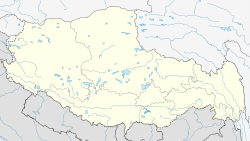
 Dêmqog
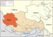
Coordinates: 32°41′40″N 79°27′45″E / 32.69444°N 79.4625°ECoordinates: 32°41′40″N 79°27′45″E / 32.69444°N 79.4625°E Country China Region Tibet Prefecture Ngari Prefecture County Elevation 4,240 m (13,920 ft) Population – Total 150 – Major Nationalities Tibetan – Regional dialect Tibetan language Dêmqog (Demchok in India, Chinese: 典角) is a very small village in the Tibet Autonomous Region of China. It lies at an altitude of 5009 metres (16,436 feet). The combined Chinese-Indian village has a population of about 150[1].
The village lies 22.7 miles east of Ukdungle (India) and 16.2 miles south of Lekong Yok. It is divided by the China-India Line of Actual Control. The Indian side is known as "Demchok" or "New Demchok." The original village was occupied by China during 1962 Sino-Indian War.
See also
- List of towns and villages in Tibet
References
External links
Towns and villages Categories:- Populated places in Tibet
- Tibet geography stubs


Wikimedia Foundation. 2010.