- Olsobip
-
Olsobip
Western Province
Papua New Guinea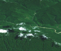
A Landsat montage of Olsobip township (centre) with the Hindemburg Wall (part of the Hindenburg Range) in the foreground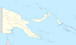
 Olsobip
District: North Fly LLG: Olsobip Rural Coordinates: 5°23′S 141°30′E / 5.383°S 141.5°ECoordinates: 5°23′S 141°30′E / 5.383°S 141.5°E Population: 1000 (2006 est) Main languages: Tok Pisin, English Mean Max Temp Mean Min Temp Annual Rainfall 29 °C
84 °F20 °C
68 °F10,000 mm
393.7 inOlsobip is a station town in the north of the Papua New Guinean Western province, located on the Upper Fly River.[1] It is the seat of the Olsobip Rural LLG. It has a rural airport (OLQ) but, set in a rich forest, it is unaccessable by road. As a result of its isolation, accurate census data is difficult to obtain from Olsobip.
Contents
History
Baptist missionaries were active in Olsobip, establishing the Olsobip Patrol Post.[2] The people of Olsobip belong to the Mountain-Ok culture area which is located in the Western range of Papua New Guinea.[3] This cultural group are noted for their crafts, particularly handdrums which they trade.[4]
Geography and climate
Olsobip is one of the northernmost stations in the province. It lies along the Upper Fly River in an isolated mountainous areas known as the Star Mountains.[5] Although no official scientific weather station has ever been established in the area it is known to be extremely wet and has been claimed to be one of the wettest places on earth with a rainfall in excess of 10m a year.[6] The villagers are known to have patches of land for growing vegetables.[5]
Transport
Olosbip is a highly inaccessible settlement. Although located along the Upper Fly River, it is not easily accessible by river and is not connected by road. The small airstrip, Olsobip Airport, was built in 1964/5 by local labourers.[4]
References
- ^ Mosquito systematics, Volumes 13-14. American Mosquito Control Association, North Carolina State University. Dept. of Entomology. 1981. p. 5. http://books.google.co.uk/books?id=2gtOAAAAYAAJ&q=Olsobip,+papua+new+guinea&dq=Olsobip,+papua+new+guinea&hl=en&ei=Z8c4TOOaLIOhnQel_KzSDw&sa=X&oi=book_result&ct=result&resnum=8&ved=0CFAQ6AEwBw.
- ^ McNeill, John Robert (2001). Environmental history in the Pacific world. Ashgate. p. 296. ISBN 0754601544. http://books.google.co.uk/books?id=WHZ-AAAAMAAJ&q=Olsobip&dq=Olsobip&hl=en&ei=asU4TKPPMMyUnQfgjbyKBA&sa=X&oi=book_result&ct=result&resnum=10&ved=0CFIQ6AEwCQ.
- ^ Journal of the Polynesian Society, Volume 84 (1975)
- ^ a b Schuurkamp, Gerrit J. T. (1995). The Min of the Papua New Guinea Star Mountains: a look at their traditional culture and heritage. p. 166. ISBN 998085099. http://books.google.co.uk/books?id=nuJyAAAAMAAJ&q=Olsobip,+papua+new+guinea&dq=Olsobip,+papua+new+guinea&hl=en&ei=TMw4TO22AtT-nAfnuMmxDA&sa=X&oi=book_result&ct=result&resnum=9&ved=0CEwQ6AEwCDgo.
- ^ a b Papua New Guinea handbook, business and travel guide. Pacific Publications. 1985. ISBN 0858070588.
- ^ McKinnon, Rowan, Carillet, Jean-Bernand, Starnes, Dean (2008). Papua New Guinea and the Solomon Islands. Lonely Planet. p. 204. ISBN 1741045800. http://books.google.co.uk/books?id=eUmcHEZLFYgC&pg=PA204&dq=Olsobip,+papua+new+guinea&hl=en&ei=zcg4TO31CtSLnQfsopHOAw&sa=X&oi=book_result&ct=result&resnum=1&ved=0CC0Q6AEwADgK#v=onepage&q&f=false.
Categories:


Wikimedia Foundation. 2010.