- Maryland Route 361
-
Maryland Route 361
Fairmount Road 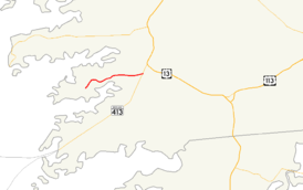
Maryland Route 361 highlighted in redRoute information Maintained by MDSHA Length: 5.62 mi[1] (9.04 km) Major junctions West end: End of state maintenance in Upper Fairmount East end:  MD 413 in Westover
Location Counties: Somerset Highway system Maryland highway system
Interstate • US • State • Minor • Former • Turnpikes←  MD 360
MD 362  →
→Maryland Route 361 (MD 361) is a state highway in the U.S. state of Maryland. Known as Fairmount Road, the state highway runs 5.62 miles (9.04 km) from the beginning of state maintenance in Upper Fairmount east to MD 413 in Westover. MD 361 provides access to the villages of Manokin and Upper Fairmount, while the county-maintained portion of Fairmount Road continues west toward the communities of Fairmount, Frenchtown, and Rumbly. The state highway was constructed from the Westover end beginning in 1926. MD 361 was completed west through Upper Fairmount in the early 1930s.
Contents
Route description
MD 361 begins on Fairmount Road between the Fairmount Volunteer Fire Department and Clinton Bozman Road on the west edge of Upper Fairmount.[1][2] Fairmount Road continues west as a county highway toward Fairmount, Frenchtown, and Rumbly. MD 361 heads east through the Upper Fairmount Historic District, passing Upper Hill Road and an old alignment of the highway, Jones Factory Road, before leaving Upper Fairmount and passing through the Chesapeake Forest Lands.[2] The state highway leaves the forest and passes through the hamlet of Manokin, where the highway intersects Millard Long Road, which heads north toward Revells Neck, and River Road, which heads south toward Kingston.[1][2] MD 361 passes the county landfill and Charles Layfield Road before reaching its eastern terminus at MD 413 (Crisfield Highway).[1] Ritzel Road, the old alignment of MD 361, continues east to its terminus at Old Westover–Marion Road, the old alignment of MD 413.[2]
History
The first section of MD 361 was constructed in 1926 from the old alignment of MD 413 west to Charles Layfield Road.[3][4] The highway was extended west through Manokin by 1930.[5] MD 361 was completed through Upper Fairmount in 1933.[6][7] The part of the state highway between MD 413 and the old alignment of MD 413 was removed from state maintenance by 1961.[8]
Junction list
The entire route is in Somerset County.
Location Mile
[1]Destinations Notes Upper Fairmount 0.00 Fairmount Road west – Fairmount Western terminus Westover 5.62 MD 413 (Crisfield Highway) – Crisfield, Princess AnneEastern terminus; Ritzel Road is old alignment of MD 361 Ritzel Road east 1.000 mi = 1.609 km; 1.000 km = 0.621 mi References
- ^ a b c d e Maryland State Highway Administration (2009). "Highway Location Reference: Somerset County" (PDF). http://www.marylandroads.com/Location/2009_somerset.pdf. Retrieved 2010-10-24.
- ^ a b c d Google, Inc. Google Maps – Maryland Route 361 (Map). Cartography by Google, Inc. http://maps.google.com/maps?f=d&source=s_d&saddr=Fairmount+Rd&daddr=Fairmount+Rd%2FMD-361+E&hl=en&geocode=FbZxRQIdQFN7-w%3BFVajRQId5MZ8-w&mra=ls&sll=38.118057,-75.707656&sspn=0.0039,0.009645&ie=UTF8&ll=38.110924,-75.756226&spn=0.06186,0.154324&t=h&z=13. Retrieved 2010-05-03.
- ^ Report of the State Roads Commission of Maryland. 1924-1926. Baltimore: Maryland State Roads Commission. January 1927. p. 27. http://www.archive.org/details/annualreportsofs1924mary. Retrieved 2010-04-01.
- ^ Maryland Geological Survey. Map of Maryland: Showing State Road System and State Aid Roads (Map) (1927 ed.).
- ^ Maryland Geological Survey. Map of Maryland Showing State Road System: State Aid Roads and Improved County Road Connections (Map) (1930 ed.).
- ^ Maryland Geological Survey. Map of Maryland Showing State Road System: State Aid Roads and Improved County Road Connections (Map) (1933 ed.).
- ^ Report of the State Roads Commission of Maryland. 1931-1934. Baltimore: Maryland State Roads Commission. 1934-12-28. p. 354. http://www.archive.org/details/reportofstateroa1931mary. Retrieved 2010-05-03.
- ^ Maryland State Roads Commission. Maryland: Official Highway Map (Map) (1961 ed.).
External links
Roads in Somerset County, Maryland State highways 
U.S. Highways Categories:- State highways in Maryland
- Roads in Somerset County, Maryland


Wikimedia Foundation. 2010.