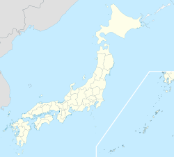
- Miyaki, Saga
-
Miyaki
みやき町— Town — 
FlagLocation of Miyaki in Saga Prefecture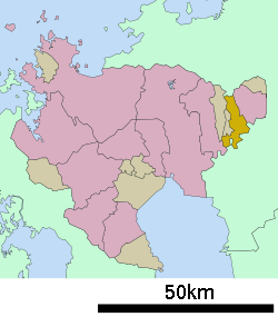
 Miyaki
Coordinates: 33°19′N 130°27′E / 33.317°N 130.45°ECoordinates: 33°19′N 130°27′E / 33.317°N 130.45°E Country Japan Region Kyūshū Prefecture Saga Prefecture District Miyaki Area - Total 51.89 km2 (20 sq mi) Population (February 1, 2009) - Total 26,734 - Density 515/km2 (1,333.8/sq mi) Time zone Japan Standard Time (UTC+9) Phone number 0942-89-1651 Address 737-5 Ōaza Higashio, Miyaki-chō, Miyaki-gun, Saga-ken
849-0113Website Town of Miyaki Miyaki (みやき町 Miyaki-chō) is a town in Miyaki District, Saga Prefecture, Japan. It is the first town in Saga to have its name spelled in hiragana rather than kanji. It is named after the district it is located in.
Contents
Geography
Miyaki is located in the eastern part of Saga Prefecture, about 20 kilometres (12 mi) east of Saga City and about 30 kilometres (19 mi) south of Fukuoka. The northern part of Miyaki contains the Chikushi Mountains, and the southern part contains the Chikugo River. It borders Fukuoka Prefecture on the north and south.
Adjoining municipalities
History
- April 1, 1889 - The present system of municipalities is established and the area occupied by Miyaki consists of the villages of Nakabaru, Kitashigeyasu, Minamishigeyasu, and Mikawa.
- April 1, 1955 - The villages Minamishigeyasu and Nakabaru merge to form Mine Village.
- May 5, 1962 - Mine Village becomes Mine Town.
- April 1 1965 - Kitashigeyasu Village becomes Kitashigeyasu Town.
- April 1, 1971 - Nakabaru Village becomes Nakabaru Town.
- March 1, 2005 - The towns of Mine, Kitashigeyasu and Nakabaru merge to form Miyaki Town.
Education
High Schools
- Saga Prefectural Miyaki High School
Junior High Schools
- Nakabaru Junior High School
- Kitashigeyasu Junior High School
- Mine Junior High School
Elementary Schools
- Nakabaru Elementary School
- Kitashigeyasu Elementary School
- Mine Higashi Elementary School
- Mine Nishi Elementary School
Transportation
Air
The nearest airports are Saga Airport and Fukuoka Airport.
Rail
- JR Kyushu
Road
- Expressways:
- There are no expressways in Miyaki. The closest interchange is the Higashisefuri Interchange.
- National highways:
- Route 34
- Route 264
- Prefectural roads:
- Saga Prefectural Routes 19, 22 and 31
Notable places
- Shirasaka Park
External links
 Media related to Miyaki, Saga at Wikimedia Commons Miyaki official website (Japanese)
 Saga Prefecture
Cities 
Districts
and TownsFujitsu Higashimatsuura Kanzaki Kishima Miyaki Nishimatsuura Categories:- Towns in Saga Prefecture


Wikimedia Foundation. 2010.